HO Guides
Takamatsu Castle: A Fortress with a Sea Door
An offshore transfer, an isolated inner enclosure and a changing shoreline explain how water could both separate a lord's residence and connect it to the world.
Quick · About 2 min
The story in five points
A short route through the argument. Follow a point into Classic for its context and sources.
Water could restrict or enable movement
Takamatsu’s seawater moats separated enclosures, concentrating access to protected ground. Its sea gate served a different purpose: authorized departure toward distant destinations. Both functions belonged to a castle connected with the Seto Inland Sea.
Read in contextThe shoreline and its structures changed
Matsudaira reclamation extended the northern enclosure. Older gate materials entered the new arrangement, while later rebuilding altered surviving fabric. Excavated landing evidence and an old photograph recover an embarkation relationship no longer visible in the same coastal setting.
Read in contextEmbarkation involved more than one vessel
A small boat carried the lord offshore to a larger fitted ship. Hiryū-maru drawings show accommodation and bodily provisions as well as display. Harbor facilities and alternate-attendance obligations place this transfer within a larger maritime and political system.
Read in contextThe inner crossing remained concentrated
Saya Bridge was the sole direct connection to the main enclosure. Its roof and approaches changed over time, so today’s route cannot supply a detailed medieval combat scenario. Swimming instruction likewise records preparation and display, rather than evidence of an actual siege maneuver.
Read in contextSurvival does not preserve one complete blueprint
The moat still connects with seawater, but historical water-control details remain unresolved. A relocated turret, reconstructed gate, and later Matsudaira villa also preserve different relationships with the past. Their shared setting does not make them an unchanged domain household.
Read in context
Opening
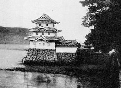
In an old photograph of Takamatsu Castle, water reaches the stonework below the Tsukimi turret. Its three tiers of roofs rise beside a low adjoining wall. Beyond the base lies open water rather than the reclaimed frontage that now separates the castle from the sea. The photograph, preserved by the Matsudaira family foundation and dated by the city to 1901 or earlier, records a relationship that the buildings alone can no longer fully show.[1]
Nearby is Mizute-gomon, the water gate. A lord departing from here could enter a small boat, then transfer offshore to his larger vessel. This was an opening in the defenses whose purpose included taking the castle's master away.[2]
Farther inside, water performed another task. It surrounded the main enclosure and left a bridge as its sole direct connection to the neighboring enclosure. Takamatsu placed restriction and departure within the same coastal complex. Understanding the castle requires following both: the water that interrupted a land approach and the sea route that began at a gate.
1. The castle's boundaries were made of water
Ikoma Chikamasa began building Takamatsu Castle in 1588, after receiving the province of Sanuki on Shikoku. The site placed his seat beside the Seto Inland Sea. The later castle comprised successive enclosures and three moat circuits supplied with seawater. Its extent was greater than the grounds retained within today's Tamamo Park.[3]
Enclosures divided the compound into manageable spaces. The innermost, the honmaru, contained the keep; the adjoining ninomaru formed another bounded area. Rather than surrounding one undivided block of buildings, the moats separated parts of the castle from one another as well as from the outside. A person already within the larger perimeter had not necessarily reached its most protected ground.
The sea added a different scale. A water obstacle might make crossing between two nearby banks difficult, while the connected maritime world made a distant shore reachable by boat. Takamatsu's arrangement exploited that difference. The castle needed places to stop a crossing and places to begin one.
These functions became especially legible under the Matsudaira family, who took possession in 1642. Their rebuilding changed the shore as well as the buildings upon it. The castle's coastal position was inherited; its later sea gate belonged to a landscape the new household enlarged.
2. Building a new edge
From 1671, land was reclaimed to form the northern enclosure, the kitanomaru. The Matsudaira were extending the castle over ground that had previously been sea. A joint in the masonry still identifies an addition beneath the Watari turret: different stretches of stonework meet where the enclosure grew.[4]
The extension changed which line counted as the edge. A sea gate serving an earlier boundary could become redundant when new ground appeared beyond it. At Takamatsu, part of that earlier arrangement was absorbed into the later building. Three southern bays of the Watari turret reused members from the old Umite gate, and investigations found former gate foundations beneath the older stretch of wall.[2][4]
This was an adjustment of a working perimeter. An older opening did not have to remain an opening for its material to remain useful. The enlarged enclosure supplied another sea-facing entrance, with a turret, connecting buildings and a landing relationship appropriate to its new position.
The Tsukimi turret was raised in 1676. Mizute-gomon stands beside this northern group, though investigation indicates that the gate now surviving was probably rebuilt late in the Edo period. The sea approach therefore continued through changes to its fabric. It cannot be dated as one untouched assembly constructed by the castle's sixteenth-century founder.[2]
On the seaward side, excavation recovered evidence of a stepped facility. The stone steps presented there now are reconstructed. Their significance is the transition they mark: from firm ground within the castle to a level where someone could embark. A gate could regulate passage through the wall; steps had to make the next stage of the journey physically possible.[4]
The old photograph restores the scale of that transition. Water spreads away from the masonry, and the turret stands directly beside it. Reclamation had created this castle edge in the seventeenth century. Further reclamation outside it would eventually alter the edge again.
3. From a small boat to a floating residence
The lord's larger vessel did not need to fit against the water gate. The documented arrangement used a small boat for the first stage, followed by transfer to the gozabune, the vessel fitted for the lord, offshore. That division connected a relatively confined embarkation point to a ship with space for a much more elaborate household setting.[2]
Takamatsu's best-documented example is Hiryū-maru. Matsudaira Yorishige ordered the first vessel of that name in 1669. It was subsequently replaced several times. A surviving set of eight drawings concerns two later rebuildings: three sheets from 1754 and five from 1792. They preserve different versions of the named ship rather than the unaltered appearance of the first hull.[5]
One 1754 sheet presents the whole vessel. A large sail rises above the hull; red and white hangings define the occupied space beneath it. Crests and the ship's name make its affiliation visible, while weapons appear alongside the decorative display. The composition brings the vessel's parts together for inspection. It need not be read as a record of one actual departure in a particular wind.[6]
Other sheets enter the accommodation. Painted partitions distinguish rooms within the raised structure, giving the vessel an interior vocabulary recognizable from a residence ashore. A plan associated with the 1792 rebuilding identifies a steam bath and a lavatory. Traveling involved bodily needs as well as a public appearance; the drawings assign those needs places within the ship.[6]
The comparison with the water gate is revealing. The gate and small boat managed the transfer from shore. The larger vessel supplied a setting in which the lord could remain while moving over a greater distance. Embarkation did not mean stepping straight from a palace room into another room of equivalent scale. It meant passing through different spaces and different craft, each answering a different part of the journey.
Such journeys included alternate attendance, the obligation to spend recurring periods at the shogun's court in Edo. For a lord based on Shikoku, leaving the domain involved crossing water. The castle's sea door connected his residence to a route required by his political position, as well as to excursions closer to home.[5]
That access also depended on arrangements beyond the gate. The domain maintained a harbor and places to keep its vessels on the castle's western side. The Kagawa Museum traces an enlargement of the dedicated harbor between 1656 and 1670.[5] The gate was an embarkation point within this larger maritime establishment, not the berth and storehouse for everything that sailed from Takamatsu.
4. The crossing that remained narrow
The route into the main enclosure posed the opposite problem. Here the moat enclosed a relatively small piece of ground, and Saya Bridge was its only direct link to the ninomaru. The keep rose within an area reached through a limited crossing rather than from a broad forecourt.[7]
A castle plan of 1627 already shows a bridge in this relationship. Early representations describe or depict a bridge with railings. By an 1823 repair drawing, the passage had a roof. The municipal bridge-repair report places these images in sequence without supplying an exact year when the first roof was added.[8]
The covered passage gives the surviving arrangement a particularly enclosed appearance, but the older relationship did not depend on a roof. Water confined entry to a particular crossing. A wall and gate at its end could then regulate movement onto the next piece of ground. The physical sequence made access divisible into stages.
It is important not to insert every bend of the modern visitor route into that earlier sequence. The city's comparison with an old plan shows that the Edo-period approach beyond the bridge differed from the present longer detour. The bridge itself also underwent movement and substantial repair in modern times.[7][8] The enclosing water and the restricted connection are clear; a detailed reconstruction of an attack cannot be read directly from today's path.
Seen together, bridge and sea gate explain two different kinds of control. At the honmaru, a bridge concentrated an approach from an adjacent enclosure. At Mizute-gomon, an authorized departure opened onto a much wider range of possible destinations. The walls did not turn all movement into the same problem. They separated an internal crossing from access to the sea.
The keep itself was dismantled in 1884 because of deterioration. Its stone base preserves the location of the tower without supplying its missing upper structure.[3] Even without that silhouette, the relationship between inner ground, surrounding water and the crossing remains available to understand.
5. Learning to enter the water
Some of Takamatsu's relationship with the sea was carried in trained bodies rather than boats. The city's account of the swimming tradition later called Suinin-ryū dates organized instruction for retainers to 1643. Yorishige directed Imaizumi Hachirōzaemon to teach swimming at the waterfront training ground west of the castle. Summer demonstrations were watched by the lord.[9]
The castle's own inner-moat history also records that Yorishige swam there in the year he arrived. The wider training ground and this episode within the moat were different locations, but both placed entry into water among the activities of the ruling household.[10]
These records add a useful qualification to the language of defensive barriers. A moat obstructed ordinary passage on foot; it was not a claim that water made every human crossing impossible. A coastal retainer could be expected to acquire skills for conditions in which a bridge or dry path was unavailable. The same environment could demand a barrier in one setting and competence in crossing it in another.
The surviving swimming tradition does not establish that a particular maneuver was used during a siege of this castle. Its more direct contribution is to the history of preparation and display. The lord's maritime setting involved ships and embarkation structures, but also repeated instruction in what a person could do once in the water. That is a different kind of adaptation from adding another wall.
6. The sea connection that survives is not a complete blueprint
The surviving moats retain a connection with the sea. In the arrangement described by the city, water passes through the sluice between the ninomaru and the sannomaru, or third enclosure. Marine life in the moat makes that connection conspicuous. Seawater belongs to the functioning site, not only to its historical name.[10]
Yet the modern sluice creates a trap for historical explanation. It would be easy to describe the visible mechanism and assume that the seventeenth-century castle operated it in exactly the same position. The city's investigation gives reasons not to do so. An old comprehensive castle drawing shows a defensive gateway arrangement rather than the present sluice, and the adjacent masonry has evidence of alteration. The historical method of managing the moat water remains unresolved in that account.[10]
Two parts of the interpretation can therefore proceed at different levels of precision. The castle's use of a coastal, seawater-filled moat system is well established. The location and operation of its earlier water-control connections require more evidence. Knowing the former does not supply the missing details of the latter.
For the sea gate, excavation and the surviving shore-facing buildings identify an embarkation relationship. For the sluice, a functioning modern connection does not by itself recover an Edo-period installation. The difference keeps the castle's practical history open to investigation without reducing the whole maritime setting to uncertainty.
It also helps explain the changed frontage. Land reclamation separated the old north wall from open sea, while a water connection was retained. The coastline could move outward without turning the remaining moat into an ordinary landlocked pond. The form of the connection changed more than the substance flowing through it.
7. A residence after the domain
The household ashore changed its position too. In 1700, the domain's palace moved into the sannomaru, an enclosure previously used in part for warehouses. Residence and government were consequently not confined to the island-like honmaru or to the keep. The larger castle provided other ground on which the household could expand its daily business.[11]
The Hiunkaku standing in that enclosure belongs to a later period. It was built between 1914 and 1917 as a villa for Count Matsudaira Yorinaga, a descendant of the former ruling house. The earlier domain palace had also been called Hiunkaku, but the shared name does not make the present building an intact residence from the age of Hiryū-maru's eighteenth-century drawings.[11]
Other retained buildings underwent different changes. The Ushitora turret was built in 1677 at the northeastern corner of the eastern enclosure and moved in 1967 to the former Taiko turret site. Its old structure survives in a new position. Sakura Gate, at the entrance to the sannomaru, burned in 1945; its replacement was completed in 2022.[2][11]
These alterations affect how the remaining ensemble can be read. A turret may retain old fabric without identifying the original edge of the castle. A new gate can restore the appearance of a lost entrance. A villa can preserve the family's later presence without continuing its former government. Takamatsu became a public city park in 1955, after the city acquired it the previous year.[3] The places through which visitors move are the result of these different decisions, not a single surviving household left ready for departure.
8. A shore no longer waiting for a boat
The old photograph holds the Tsukimi turret against water extending beyond its base. Its principal historical detail is the edge itself. It records where masonry ended and the sea began, before a larger reclaimed frontage intervened.
The ship drawings supply what the photograph lacks: the accommodation that waited beyond an embarkation point. The bridge plans supply another relationship, concentrating entry to the main enclosure. Together, these materials distinguish a sea-facing threshold from an internal crossing. Both belonged to the castle, but they did not serve interchangeable journeys.
Takamatsu's defenses took advantage of water without making separation their only purpose. A lord could be protected within successive enclosures, cross to the northern gate, and leave by boat for obligations elsewhere. His residence was connected to an offshore vessel and a maritime route through an ordered transfer, rather than through an uninterrupted extension of dry ground.
That route no longer operates from the gate. What survives is uneven but specific: the sea-facing entrance, the turret beside it, archaeological evidence for steps, the isolated keep ground, and moats still connected to seawater through an altered arrangement. The former shoreline can be recovered in a photograph; the former ship in drawings. The castle becomes intelligible when the different crossings are put back in relation—not when every remaining stretch of water is assigned the same job.
Next topic · HO Guides
Kōrakuen: What the Lawn Replaced
Rice planting, a water shortage and an economy measure help explain how a working garden acquired its open view.
Continue readingSources and NotesView sourcesHide sources
- [1]
Tsukimi turret historical photograph, Matsudaira Kōekikai (公益財団法人松平公益会), reproduced by Takamatsu City on “北ノ丸,” “水手御門.” https://www.city.takamatsu.kagawa.jp/smph/kurashi/kurashi/shisetsu/park/tamamo/kitanomaru.html . The city dates the photograph to Meiji 34 (1901) or earlier and identifies its view as preceding reclamation. The photograph: https://www.city.takamatsu.kagawa.jp/kurashi/kurashi/shisetsu/park/tamamo/kitanomaru.images/tukimikoshashin.jpg . Visible water, masonry, roofs and adjoining wall are described qualitatively. No precise tidal stage, photographic date or vanished feature outside the image is inferred.
Return to the reference ↑ - [2]
Takamatsu City, “高松城,” designated-built-heritage description, updated 1 September 2025, entries for 月見櫓、水手御門、渡櫓、艮櫓. https://www.city.takamatsu.kagawa.jp/smph/kurashi/kosodate/bunka/bunkazai/shiteibunkazai/kenzo/siro.html . Supports the small-boat/offshore-vessel transfer, the probable late-Edo rebuilding of the surviving water gate, reuse of three bays' worth of older gate members, and Ushitora's 1677 construction/1967 relocation. The dating of the surviving Mizute gate is an architectural interpretation, not a dated founding inscription. The essay omits the competing degrees of certainty in municipal explanations of the name Tsukimi, and makes no claim that a large lord's vessel sailed through the gate or berthed within the inner moat.
Return to the reference ↑ - [3]
Takamatsu City, “史跡高松城跡の歴史,” sections “高松城の歴史” and “高松城案内,” updated 4 September 2025. https://www.city.takamatsu.kagawa.jp/smph/kurashi/kurashi/shisetsu/park/tamamo/bunzai201806051.html . Used for 1588 construction under Ikoma, Matsudaira possession in 1642, the three seawater moat circuits and larger original extent, dismantling of the keep in 1884, municipal acquisition in 1954 and public park opening in 1955. No universal claim of invulnerability or reconstruction of a fought siege is made. The empty keep platform is not used to endorse or oppose a modern rebuilding proposal.
Return to the reference ↑ - [4]
Takamatsu City, “北ノ丸,” opening paragraph and subsections “渡櫓台に見られる石垣の継ぎ足し痕,” “水手御門,” “渡櫓,” updated 1 March 2018, URL in note 1. The page explains reclamation from 1671, the masonry addition, excavation of the former Umite gate foundations and the recovered stepped facility. The present landing steps are explicitly described as reconstructed. This is the city's archaeological/architectural interpretation, not an independent reexcavation or new masonry measurement. The sources in notes 2 and 4 overlap institutionally and are not counted as independent confirmation of every building date.
Return to the reference ↑ - [5]
The Kagawa Museum, “御座船『飛龍丸』と高松城,” NEWS, vol. 64, Spring 2025, printed pp. 2–3 (PDF sheet 2), sections “御座船『飛龍丸』を描いた絵図” and “『飛龍丸』と高松城.” https://www.kmuseum.pref.kagawa.lg.jp/wp-content/uploads/2025/10/newsvol64.pdf . Used for the first Hiryū-maru in 1669, the separate 1754/1792 drawing groups, the use of lord's vessels for alternate attendance, and the harbor enlargement dated between 1656 and 1670. The feature's larger interpretation of a shogunal surveillance mandate is not adopted, and the article supplies neither an exact voyage timetable nor crew size. The harbor is limited background explaining the castle's gate, not an expansion of the Place to all of the modern port.
Return to the reference ↑ - [6]
“高松藩飛龍丸船明細切絵図,” Matsudaira Kōekikai, historical drawings dated 1754 and 1792, reproduced as figures 1–3 in the Kagawa Museum feature cited in note 5. Figure 1: 1754 whole-vessel representation; figure 2: stern/interior decoration; figure 3: 1792 plan. Sail, hangings, crests, painted partitions and the relation of accommodation to hull are readings of the reproduced historical images; the steam bath and lavatory identification follows the museum's explanation. The proposed cooking space is omitted because the curator qualifies it. These construction/rebuilding records are not treated as eyewitness images of one departure, proof of a particular sea condition, or complete plans independently measured by this writer.
Return to the reference ↑ - [7]
Takamatsu City, “本丸,” opening account and “鞘橋” discussion. https://www.city.takamatsu.kagawa.jp/smph/kurashi/kurashi/shisetsu/park/tamamo/honmaru.html . Used for the honmaru's enclosing water, the sole bridge connection and the city's comparison of the former approach with the modern detour. No ancient combat choreography is inferred from a present visitor path; the city page's suggested motives for adding a roof are not presented as established private intentions.
Return to the reference ↑ - [8]
Takamatsu City Board of Education, 『史跡高松城跡鞘橋修理工事報告書』, Takamatsu City Cultural Property Survey Report 135, Castle Conservation Report 5, 31 January 2012, printed p. 6, “第5節 鞘橋の歴史的環境,” figures 1–3. Record: https://sitereports.nabunken.go.jp/ja/20111 . Scanned PDF: https://sitereports.nabunken.go.jp/files/attach_mobile/27/27291/20111_1_%E5%8F%B2%E8%B7%A1%E9%AB%98%E6%9D%BE%E5%9F%8E%E8%B7%A1%E9%9E%98%E6%A9%8B%E4%BF%AE%E7%90%86%E5%B7%A5%E4%BA%8B%E5%A0%B1%E5%91%8A%E6%9B%B8.pdf . See the contents pages and printed p. 6 (PDF page 12). That page discusses the 1627 drawing, early railing bridges, the roof depicted by the 1823 repair drawing, and uncertainties around modern movement of the bridge. Attempts to render the following plate page failed; the essay therefore does not claim an independent inspection of the 1823 original plate or all subsequent repair documentation. No unsupported exact roof-addition or relocation date is supplied.
Return to the reference ↑ - [9]
Takamatsu City, “水任流泳法,” 解説, updated 3 February 2026, quoting the historical explanation in 『高松の文化財』 (1992). https://www.city.takamatsu.kagawa.jp/smph/kurashi/kosodate/bunka/bunkazai/shiteibunkazai/mukei/eiho.html . Supports instruction ordered in 1643, Imaizumi's role, summer demonstrations and the later naming history. The article treats this as the city's documented account of the tradition, not an independently reconstructed seventeenth-century syllabus. It supplies no claim that present strokes are unchanged or that a recorded battlefield escape established their effectiveness.
Return to the reference ↑ - [10]
Takamatsu City, “内堀,” opening and sections “水門,” “堀の中の生き物,” “水任流,” updated 1 March 2018. https://www.city.takamatsu.kagawa.jp/smph/kurashi/kurashi/shisetsu/park/tamamo/uchibori.html . Read for the present sea connection, the absence of the modern sluice from 『旧高松御城全図』, adjacent masonry alteration and the explicit uncertainty about earlier moat-water management. This is the municipality's comparison: the original comprehensive map was not independently transcribed or measured. The recorded Yorishige swim is attributed to the city account. The article omits unverified operational schedules, water depths and claims that present sluice placement reproduces Edo-period hydraulics; no swimming or access recommendation is implied.
Return to the reference ↑ - [11]
Takamatsu City, “三ノ丸,” opening and sections “桜御門,” “披雲閣,” updated 1 September 2025. https://www.city.takamatsu.kagawa.jp/smph/kurashi/kurashi/shisetsu/park/tamamo/sannnomaru.html . Supports the domain palace's move in 1700, the 1914–1917 villa for Count Matsudaira Yorinaga, the shared name but different buildings, and Sakura Gate's 1945 loss/2022 reconstruction. The essay does not treat the present villa as the Edo-period palace or the gate reconstruction as original fabric, and makes no promise of interior entry or future construction.
Return to the reference ↑