HO Guides
Kōrakuen: What the Lawn Replaced
Rice planting, a water shortage and an economy measure help explain how a working garden acquired its open view.
Quick · About 2 min
The story in five points
A short route through the argument. Follow a point into Classic for its context and sources.
Cultivation belonged to the garden’s beauty
Kōrakuen originally combined rice fields, buildings, and carefully managed views. Actual farming contributed to a rural scene appreciated by its patrons. Creation overlapped with use, while regional drainage works helped make the garden’s position possible.
Read in contextIts water belonged to a wider system
Water supplied both fields and ornamental features. During a recorded shortage, the garden’s intake was suspended pending delivery to coastal paddies. The order reveals dependence on regional distribution, without proving how much water was saved or whether all needs were met.
Read in contextPlanting connected labor and performance
Records follow invited workers through planting, washing beneath Ryūten, and dancing near the lord’s residence. Later entries specify food and sake supplied according to precedent. These were organized occasions involving real agricultural tasks, rather than scenery populated by anonymous performers.
Read in contextLawn replaced particular tasks, not ugliness
An economy measure reduced cultivation and its workforce, converting fields to grass and changing the stream’s prominence. Some fields and planting occasions later returned. The landscape emerged through reduction and partial restoration, not a simple advance from agriculture to art.
Read in contextAn open view still required administration
Maps and accounts reveal resident staff, hospitality, and differentiated visitors. Permitted entry under the lords preceded prefectural public ownership. Floods, wartime destruction, and reconstruction added further changes, leaving surviving buildings and recovered forms with different histories.
Read in context
Opening
In 1739, a party of rice planters finished work in the garden behind Okayama Castle. Before proceeding to dance near the lord's residence, they washed their feet beneath Ryūten, a pavilion with a stream running through its ground floor. The garden's record preserves the sequence: planting, washing, then dancing before Enyō-tei.[1]
Ryūten still stands in Kōrakuen. Its water channel and colored stones belong to a carefully composed setting.[13] In that eighteenth-century entry, the same place performs a task for people who have been working in a field. Their washing does not explain the pavilion's entire design. It does restore an activity that a view of the building alone would scarcely suggest.
The broad lawns around Kōrakuen's ponds can make the rice fields seem like small additions to an otherwise finished garden. Historically, the relationship was almost the reverse: cultivation occupied much more of the grounds, and some of the openness now admired resulted from its removal. Following that change reveals a garden whose appearance depended on decisions about water, employment, hospitality and where the lord wished to look.
1. A retreat within a cultivated landscape
Ikeda Tsunamasa, the territorial lord of Okayama, ordered work on the garden in 1687. His senior official Tsuda Nagatada supervised the undertaking. The lord was already using the grounds in 1689; the expansion conventionally marking substantial completion came in 1700. Creation and occupation overlapped. This was a place adjusted through use, rather than an untouched composition unveiled on one opening day.[2]
Its convenient position behind the castle had been made more secure by works outside the garden. The development of the Hyakken River flood channel helped stabilize land beside the Asahi River. Tsuda's responsibilities joined garden-making to the domain's larger program of drainage and reclamation. The retreat occupied ground shaped by the management of water across the surrounding district.[3]
Within it, fields belonged to the intended appearance. Yamada Sadatsune, a secretary serving Tsunamasa, described rice plots and thatched buildings in language evoking a rural settlement. His account, discussed by environmental historian Ono Yoshirō, supports a conception in which cultivated ground contributed to the pleasure of the place.[2] Agriculture was not simply an older use awaiting removal before garden-making could begin.
That relationship is easy to flatten. Calling the fields ornamental might suggest they were only representations of farming. Calling them productive might imply that their appearance was irrelevant. The planting records show actual agricultural work; the secretary's description places a rural scene within the patron's cultivated surroundings. These uses could occupy the same patch of ground.
The combination also gave the garden different rhythms. A building could remain available for reception while a field required attention at particular stages of the agricultural year. The lord could arrive to view an operation that other people had been summoned to perform. His leisure and their work met here without becoming the same activity.
2. Water with another destination
The stream passing through Ryūten was part of a larger water arrangement. Ono's account of historical drawings describes a supply from the Gion irrigation channel, carried toward the garden through a long wooden conduit operating as a siphon. Water that entered the grounds could serve cultivated plots as well as ponds and the stream's ornamental course.[4]
For a rice field, the important relationship is between a supply and ground that needs irrigation. For a pavilion, the same flowing water can be appreciated for its movement among stones. Neither use creates a separate substance. They become different demands upon a connected resource.
A shortage in 1759 made the connection explicit. An order suspended the garden's intake until water had reached newly developed paddies toward the coast; only after that was confirmed was the garden to take water again.[3] The instruction establishes a priority in a particular shortage. It does not tell us the volume saved or prove that every downstream cultivator received enough.
What it does show is the garden's dependence on decisions extending beyond its boundary. Water could not be treated as perpetually available merely because it had entered an attractive design. An instruction issued elsewhere could interrupt the flow through that design. The managed landscape around the garden remained involved in the landscape within it.
This gives the winding stream a history that is difficult to see in its shape. Its curves belong to a composition; its supply belonged to a distribution problem. When fields were later converted to lawn, the visible setting of the water changed more readily than the fact that water had to come from somewhere.
3. Planting for an audience
The 1739 entry gives agricultural work an unusually clear place within a courtly occasion. Preparations called for fifteen planting women, five men, a worker to puddle the soil and a village headman. The record then follows the party through the planting and onward to washing beneath Ryūten and dancing near Enyō-tei.[1]
The numbers distinguish tasks instead of presenting an anonymous crowd of rural performers. Preparing the soil and planting the seedlings were necessary to the field; organizing attendance and proceeding to the dance made the day's work an arranged event. These were connected operations, not a choice between real farming and a theatrical imitation of it.
The change of place is equally revealing. The planters did not remain figures in a distant view. After working, they moved to the pavilion, then toward the residence. The stream made washing possible along that sequence. Enyō-tei supplied another destination, where the party's activity became a performance close to the lord's quarters.
A further entry from 1744 places Tsunamasa's son and successor, Tsugumasa, at Enyō-tei for a meal and the viewing of planting and dance. It also records red rice and sake for the male and female planters, supplied through the garden office according to precedent. Dancing extended to the offices of the officials responsible for the grounds.[1]
The references to precedent turn a picturesque occasion into an arrangement that could be repeated. Someone preparing the event had a previous practice to consult: who should come, where activities should occur, and what should be supplied. The meal for the workers belonged within that arrangement. It is not necessary to invent a feeling of shared contentment to understand what the provisions accomplished.
These entries survive in the Gokōen shoji todomechō, the garden's record of miscellaneous affairs. Officials recorded its business over generations. The records provide actions that a planting scene in a painting would not establish by itself: instructions to attend, a particular movement through the grounds, and the provision of food. At Ryūten, they return people with a specific reason to use the water to a building now chiefly encountered as scenery.[9]
4. Changing the view, changing the work
Kōrakuen's viewpoints changed before its fields were extensively reduced. Tsugumasa added Yuishinzan, an artificial hill about six meters high, and a pond linking existing water features. Work on these changes began around 1724. A garden experienced from buildings now offered an additional relationship: an elevated prospect reached by moving through it.[5]
The hill did not simply add another object to the view from Enyō-tei. It created somewhere else from which to see. From a fixed room, the disposition of nearby ground gives the prospect its frame; from higher ground, the same water and planting can be understood in a wider arrangement. The change concerned the position of the viewer as well as the shape of the garden.
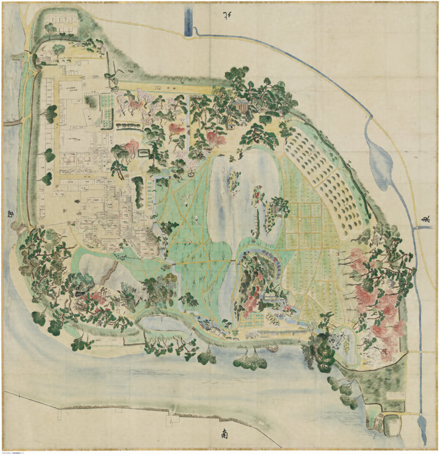
In 1771, under a later lord, Harumasa, a different kind of decision altered the ground. The garden's published history attributes the reduction of its cultivation workforce and the conversion of fields to grass to an economy measure. Land between Enyō-tei and Renchi-ken, another pavilion, became lawn. A watercourse previously serving fields acquired a new prominence as a curving stream through open turf.[5]
A map revised in the eleventh month of that year records the alteration. Its catalogue identifies fields south of the pond changed into lawn and a supplementary sheet listing modifications ordered by Harumasa. The drawing is also colorful and carefully composed, with autumn foliage distinguished. A record of practical alteration could itself present the grounds as a landscape worth looking at.[6]
The transition changed the relationship between the field and its workers. Where cultivation ceased, their particular agricultural tasks were no longer required. Grass still needed care; the evidence does not establish that all work disappeared or provide a calculation of the saving. What changed visibly was the land cover, and what changed administratively was the employment attached to cultivating it.
Nor did 1771 settle the garden's direction. Fields were reopened in its eastern part in 1773. In 1783, planting by women was resumed as an occasion, with Harumasa watching from Ryūten's upper floor.[7] The return was selective. The garden retained open ground while recovering some cultivation and its associated performance. Its later form emerged from reduction and partial restoration, rather than a steady progression from agriculture to art.
5. The inhabited ground around the scenery
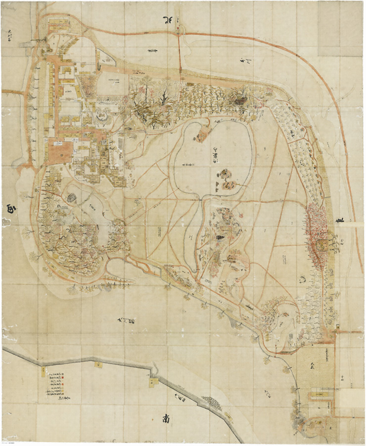
A map of 1863 gives the later arrangement a particularly full form. Central lawns, Sawa-no-ike pond and Yuishinzan appear alongside the Seiden fields and tea planting farther south. Areas of regular cultivation remain within a layout of irregular water edges, groves and paths. The surviving rice plots therefore belong to a long process of reshaping the garden's agricultural ground, not to a separate rural exhibit added to an otherwise unrelated place.[8]
The drawing also makes space for numerous buildings. Its catalogue explains that retainers and service workers concerned with upkeep lived within the grounds. Looking across the map, the densely drawn buildings and the open center occupy different kinds of space. The prospect depended on a place where people also stayed, worked and dealt with recurring business.
That occupation becomes more specific in the food records. Researcher Une Satsuki compared entries about sushi in the published transcription of the garden's accounts. One comparison concerns female attendants visiting for Inari worship in the 1860s. Their food was called sumeshi, vinegared rice. Half a year later, a preparation for women of higher household standing was called chirashizushi. The recorded ingredients were almost identical, apart from the size of the shrimp.[9]
Une treats the earlier dish as probably a form of scattered sushi despite its different name. The comparison is small but useful: hospitality involved distinctions in how food was described, even where its contents closely resembled one another. The garden's occasions were administered at this scale too, through the designation of recipients and the dishes supplied to them.
These were different connections to cultivation from the work of the rice planters. The records do not establish that these meals used grain grown inside the grounds. They reveal a garden participating in a household's provisioning and ceremonial calendar, rather than operating as an isolated agricultural estate. People could belong to its history as residents, workers, attendants or guests, each encountering the same landscape through a different undertaking.
The 1863 drawing and the accounts consequently fill different gaps. The map holds buildings and fields together in space. The entries put particular people and occasions into that arrangement. Read beside the lawn, they recover the inhabited garden without requiring an invented scene of everyone enjoying it at once.
6. Permission to enjoy the grounds
Kōrakuen was also opened to people who neither owned it nor worked there. Tsunamasa enjoyed Noh, the drama of chant, music and measured movement, and performed himself. A stage built in 1707 accommodated performances shown to retainers' families and townspeople. Later lords allowed visits on specified days while absent on their required stays in Edo, the shogun's capital.[10]
The distinction was between a permitted visit and unrestricted access. In 1746, garden-viewing days were posted at the north gate, following an earlier custom. The written announcement made admission something people could anticipate, while retaining the authority to decide when it would happen.[7]
Other visitors were received through arrangements for food and rest. The garden's historical account describes refreshments distributed among buildings, allowing guests to stop as they moved through the grounds. A garden visit could thus be organized as a succession of hosted pauses. The planting party's movement from field to pavilion to residence was one sequence among several, each with its own purpose.[10]
After the domain government ended, ownership and admission changed again. In 1884, the Ikeda family transferred the garden to Okayama Prefecture for preservation. Its initial public status was as grounds attached to the prefectural administration, with rules including closure at sunset and permission for only three tea businesses.[11]
Public use therefore had both precedents and a new institutional basis. Earlier visitors had entered a lord's garden by permission. The prefecture took responsibility for preserving grounds intended for a broader visiting public. In either arrangement, enjoyment required decisions about access, upkeep and services. What changed was who made those decisions and the relationship between the garden and those admitted.
7. The past preserved in an open view
The garden encountered further changes that were not choices between crops and grass. Flooding in 1934 and wartime destruction in 1945 caused extensive damage. Repair drew on historical plans, but also simplified parts of the path system. Even the land's relation to the river changed: flood-control works after the 1934 disaster brought a branch of the Asahi around the garden's eastern side, making it a complete river island.[12]
Enyō-tei was reconstructed in 1960. Ryūten and Renchi-ken had escaped the wartime destruction. The buildings now encountered together consequently preserve different relationships with the past: surviving fabric in some places, a recovered architectural arrangement in another. They cannot all be assigned to the garden's founding moment.[12][13]
For the fields and lawns, historical plans are particularly important. A room can be rebuilt to an earlier arrangement, but grass does not announce which year its patch ceased to be cultivated. The 1771 map records a deliberate change; the 1863 map records its later coexistence with retained fields and a populated service landscape. Together with the officials' accounts, they make the open ground historically specific.
The lawn did not replace an absence of beauty. Rice fields had already belonged to a setting made for appreciation, and planting had supplied an occasion for watching, feeding and performing. What the lawn replaced, in particular areas and at particular times, was cultivation and the work attached to it. That replacement changed how the same water and pavilions appeared. Kōrakuen's open view preserves the result; its fields, stream and records allow the earlier relationships to be seen again.
Next topic · HO Guides
Takamatsu Castle: A Fortress with a Sea Door
An offshore transfer, an isolated inner enclosure and a changing shoreline explain how water could both separate a lord's residence and connect it to the world.
Continue readingSources and NotesView sourcesHide sources
- [1]
『御後園諸事留帳』, entries for Genbun 4 (1739), fifth lunar month, twenty-third day, and Enkyō 1 (1744), as transcribed and quoted by Ono Yoshirō (小野芳朗) in “環境史から見た川利用と都市,” Mizukan Forum, 2006, PDF pp. 3–4, section “後楽園の事例に見る記憶の再生.” https://www.mizu.gr.jp/images/main/archives/forum/2006/forum2006_ono.pdf . The essay uses the quoted historical entries for attendance categories, planting, washing beneath Ryūten, dancing by Enyō-tei and the provision of red rice and sake. It does not adopt the lecturer's extrapolation to daily foot-washing, his account of officials becoming tipsy and dancing, or his explanation of fewer dance rounds as evidence of an economic decline. The 1739 lunar date is not silently converted to 23 May. The complete original diary was not read.
Return to the reference ↑ - [2]
Ono Yoshirō, “景観と歴史―記憶の表象としての空間,” Japan Society of Civil Engineers, landscape/design research proceedings, 2008, section 3(1), PDF pp. 2–3, especially the founding chronology and the quotation attributed to Yamada Sadatsune (山田定経). https://www.jsce.or.jp/library/open/proc/maglist2/00897/2008/pdf/B52C.pdf . The quoted early description is used through this researcher's transcription, not through a claimed independent reading of Yamada's complete manuscript. The article does not adopt the paper's theory of how a national garden ranking arose, its unrelated Meiji-year typo, or its broader political interpretation of borrowed scenery.
Return to the reference ↑ - [3]
Okayama Kōrakuen, “歴史・概要,” “藩主のやすらぎの場の創出” and chronology entry 宝暦9年(1759), updated 1 April 2024. https://okayama-korakuen.jp/rekishi/index.html . The regional engineering account identifies the Hyakken River works, stabilization of the garden site and Tsuda's combined responsibilities; the chronology describes the instruction suspending intake pending water reaching coastal new fields. This is the garden authority's historical synthesis, drawing on its published history, not this writer's independent reading of the full construction accounts or original 1759 order. No quantified saving, distribution outcome or judgment of the lord's character is inferred.
Return to the reference ↑ - [4]
Ono, “環境史から見た川利用と都市,” PDF p. 2, paragraphs on 祇園用水 and the wooden siphon, URL in note 1. Used for the historical water-supply relationship, not a reconstruction of an exact pipe diameter, discharge or every stage of installation. The lecture's statements about pumps and water quality describe conditions discussed in 2006 and are not presented as verified present-day conditions. The contrast between irrigation demand and the viewing of flowing water is the essay's functional interpretation.
Return to the reference ↑ - [5]
Okayama Kōrakuen, “4.後楽園の変化,” all three historical paragraphs, updated 2 May 2023. https://okayama-korakuen.jp/rekishi/about/rekishi/484.html . Supports Tsugumasa's hill and pond changes, the reduction of cultivation labor under Harumasa, conversion of fields between Enyō-tei and Renchi-ken, the changed appearance of the channel, and subsequent restoration of eastern fields. The start around 1724 is in the chronology cited in note 3. The source's fiscal explanation is attributed; no payroll, wage total or demonstrated net saving is reconstructed. Harumasa is not mislabeled as Tsunamasa's grandson.
Return to the reference ↑ - [6]
“御後園絵図(明和8年),” revised in the eleventh lunar month of 1771, Okayama University Library, reproduced and catalogued in Cultural Heritage Online. https://online.bunka.go.jp/heritages/detail/193332 . The catalogue's 解説 identifies the changed fields south of the pond, the supplementary list and autumn coloring. The full supplied map image: https://online.bunka.go.jp/heritage/14182/_129012/14182_129012100325195708062_900.jpg . The essay distinguishes broad visual observation from the catalogue's identification of alterations; the small handwritten list was not independently transcribed, and no area measurements are claimed.
Return to the reference ↑ - [7]
Okayama Kōrakuen, “岡山後楽園関係年表,” entries for 1746, 1771, 1773 and 1783, within “歴史・概要,” URL in note 3. These distinguish the workforce/land-cover change, reopening of eastern fields, and later resumption of the planting occasion. The 1783 entry specifically places Harumasa on Ryūten's second floor. The chronology and the explanatory page in note 5 belong to the same institutional source chain, not two independent confirmations of the economy measure.
Return to the reference ↑ - [8]
“御後園絵図(文久3年),” 1863, Okayama University Library, catalogue and image in Cultural Heritage Online. https://online.bunka.go.jp/heritages/detail/165291 . The 解説 identifies the lawns, Sawa-no-ike, Yuishinzan, Seiden and tea fields, and explains the numerous buildings in relation to resident retainers and service workers. The supplied map image: https://online.bunka.go.jp/heritage/14182/_129011/14182_129011100325194923145_900.jpg . Observations of regular plots, paths, water edges and clustered buildings are qualitative readings of that historical representation. The map is not treated as a measured census or as proof of a particular unnamed worker's daily itinerary.
Return to the reference ↑ - [9]
Une Satsuki (畦さつき), “岡山後楽園に関する江戸時代の記録『御後園諸事留帳』に掲載のすしについての一考察,” Journal of Cookery Science of Japan 53, no. 6 (2020): 401–414, specifically pp. 401–403, introduction, methods and section 3(1), paragraph beginning “元治年代に稲荷参詣に出向いた女中…”. DOI 10.11402/cookeryscience.53.401. https://www.jstage.jst.go.jp/article/cookeryscience/53/6/53_401/_pdf/-char/ja . See these pages, including p. 403. The study uses a published selection transcribed from the much larger surviving records; neither its edition nor the original diary was read in full here. The food identification remains Une's interpretation of recorded names, ingredients and containers. The essay makes no claim that all classes received identical food, that naming had a single proven motive, or that the rice came from the garden's fields.
Return to the reference ↑ - [10]
Okayama Kōrakuen, “3.ともに楽しむ庭,” historical paragraphs on permitted entry, Noh and hospitality, updated 2 May 2023. https://okayama-korakuen.jp/rekishi/about/rekishi/482.html . The 1707 stage/performance entry is in the chronology cited in note 3. Used for organized admission and refreshments at different buildings, not unrestricted public access or equal treatment. Large reported festival attendance totals and private emotions are omitted. The modern institution's celebratory language is not adopted as an independent judgment of social relations.
Return to the reference ↑ - [11]
Okayama Kōrakuen, “歴史・概要,” “5.岡山県に譲渡,” URL in note 3. Used for the 1884 preservation transfer, the initial designation as prefectural-administration grounds, sunset closure and three authorized tea businesses. Those are historical rules, not present-day visitor instructions. The essay does not infer free admission or uninterrupted identical access from the word “public.”
Return to the reference ↑ - [12]
Okayama Kōrakuen, “6.災害と復旧,” historical paragraphs, updated 2 May 2023. https://okayama-korakuen.jp/rekishi/about/rekishi/489.html . Supports the 1934 flood, 1945 destruction, use of old plans with some path simplification, the post-flood eastern river branch and 1960 Enyō-tei reconstruction. The present island is not projected back unchanged to 1687; documented reconstruction is not described as original material survival.
Return to the reference ↑ - [13]
Okayama Kōrakuen, “後楽園の歩き方,” named building entries for 延養亭、流店、廉池軒. https://okayama-korakuen.jp/arukikata.html . Used only for the documented fabric distinctions and Ryūten's stream-and-stones arrangement, not its proposed itineraries or live opening schedules. “Escaped wartime destruction” does not mean that every component has remained unrepaired since construction. The essay promises no interior access.
Return to the reference ↑