HO Guides
Kōyasan to Kumano: A Journey with Several Centres
A branching path, a river journey, and a folded painting reveal the different connections within one mountain religious landscape.
Quick · About 2 min
The story in five points
A short route through the argument. Follow a point into Classic for its context and sources.
A sacred centre could contain several destinations
Kōyasan joins ritual precincts, institutional leadership and devotion at Kūkai’s mausoleum. Its pagoda arranges a Buddhist world through figures and space, while Okunoin gives continuing offerings a destination; reaching the settlement does not collapse these different religious purposes.
Read in contextThe roads crossed inhabited ground
The Kohechi alternates mountain passes with settlements and valleys. Tea-house remains and remembered local uses place residents and livelihoods along the connection, showing that a traveller’s stopping place could also be someone else’s fixed workplace.
Read in contextThe approach already contained worship
Along the Nakahechi, subsidiary ōji offered places for preparation, rest and devotion. Thresholds such as Takijiri and Hosshinmon gave movement religious stages before arrival, while the river supplied another connection from Hongū towards Hayatama.
Read in contextDistinct landscapes remained distinct
Hongū’s flood-driven relocation left buildings and the former river precinct in different places. Nachi joins waterfall, shrine and temple; pilgrimage paintings make that setting intelligible through repeated figures and compressed scenes rather than measured geographic scale.
Read in contextReligious intermediaries carried the mountains outward
Portable Nachi paintings served travelling explanation, including work by Kumano bikuni. Their institutional relationships linked audiences, contributions and return visits, extending religious connection to people away from the shrines without requiring everyone to undertake the mountain journey.
Read in context
Opening
Near Kumano Hongū, a stone directs travellers towards somewhere else. Its inscription points right to Kōyasan, nineteen and a half ri away, and left to Kimiidera, thirty-one and a half. It stands at Sangenjaya, the junction remembered for its three tea houses. A person approaching the great Kumano shrine could also be thinking about the road beyond it.[1]
The stone offers a useful correction to a journey imagined as a line ending at one final sanctuary. In the Kii Mountains, an arrival could become a departure. The sacred centres were related without being interchangeable, and the ways of moving between them included more than walking.
How did these different places hold together as a religious landscape? The answer involves the ground crossed, the stops that gave an approach its religious form, and images through which the mountains could reach people who remained elsewhere.
1. A mountain with more than one focus
Kōyasan's institutional beginning is associated with Kūkai's establishment of a Shingon Buddhist centre in 816. Shingon, the tradition he developed after studying in China, uses ritual, images, and the body in the pursuit of Buddhist awakening. The mountain settlement provides different settings for that religious work: the Danjō Garan is a principal ritual precinct; Kongōbu-ji supplies institutional leadership; Okunoin directs devotion towards Kūkai himself, remembered as Kōbō Daishi.[2]
Already, the name on the direction stone is larger than one destination building. Reaching the settlement is not the same thing as completing every religious approach within it. A person can be at Kōyasan while still moving towards a particular focus of worship.
At the Garan, the great pagoda known as the Konpon Daitō gives a Buddhist universe architectural form. Its central Dainichi, the Universal Buddha, is surrounded by other sacred figures, with bodhisattvas—beings dedicated to helping others towards awakening—painted on the columns. The temple describes the arrangement as a three-dimensional mandala: an ordered representation of a sacred world, here made through figures and the space between them.[3]
The standing pagoda is a 1937 rebuilding. Its designers used historical records and evidence from the foundations, while combining reinforced construction with timber. The building's date is much later than the teaching it represents.[4] This gives the Garan a particular kind of historical depth. An inherited religious arrangement has been made available through another generation's architecture.
Okunoin establishes a different relationship. Shingon tradition holds that Kōbō Daishi remains in meditation at his mausoleum. The surrounding cemetery consequently draws remembrance towards someone understood as continuing to act for the living, rather than simply towards the resting place of an admired historical teacher.
A temple interview recorded in 2025 makes that belief concrete. An Okunoin monk describes meals prepared by monks in the offering kitchen and carried in a covered container to the Lantern Hall before the mausoleum. The meals are vegetarian; a record of menus helps avoid excessive repetition.[5]
That last detail gives the continuing presence a remarkably domestic expression. Variety matters when food is being prepared for someone, rather than merely used as a timeless emblem. The kitchen and the place of presentation have different functions within one act of care.
The pagoda and the mausoleum therefore do not ask exactly the same thing of their surroundings. One arranges sacred figures into a comprehensible religious world. The other gives continuing service a destination. The paths within Kōyasan connect these activities without making a single building stand for all of them.
2. Between the sanctuaries, people lived
The Kohechi links Kōyasan with the Hongū area across the interior mountains. Its geography is demanding: repeated ascents over high passes alternate with descents towards settlements and rivers. The route's modern overview map makes that pattern plain. This is not one continuous climb followed by a single descent to the shrine.[6]
The valleys are as important to its history as the summits. Near Miura, the recorded remains include tea-house sites, the former Yoshimura household site, distance stones, and Buddhist monuments. They place habitation and small stopping places within the mountain connection. A road that now appears intermittently remote once passed places where somebody had reason to stay.
Nara Prefecture's local heritage account recalls the route's importance before modern highways. Residents used it to reach Kumano or travel towards Osaka through Kōyasan; merchants also passed along it. Before mountain roads were developed, sections served journeys to work and school.[7]
Those later uses should not be transported unchanged into the Middle Ages. They do establish that a pilgrimage path could remain part of local life. Religious travel and ordinary movement occupied some of the same ground, rather than belonging to two separate road systems.
A tea house captures the relationship neatly. For a traveller, it is an interruption in movement. For the people providing it, the passing road is a reason for activity at one fixed location. The same place can belong to someone's journey and someone else's working day.
That helps explain the significance of Sangenjaya's branching directions. Paths reached settlements, crossed other paths, and offered alternatives. The region could sustain connections among sacred centres because those centres belonged to an inhabited geography, not because the space between them had ceased to matter.
3. A road could begin the worship before arrival
The Kohechi meets the Nakahechi approach near Hongū. Along the Nakahechi, subsidiary sacred places called ōji divide the approach into more than intervals of distance. They are associated with Kumano's deities and supplied places for worship and rest. The familiar designation of ninety-nine ōji expresses their abundance, rather than providing a reliable count of an unchanging set.[8]
Two names show how such places organized an approach. Takijiri-ōji marks entry into the sacred mountain region, beside rivers associated with purification. Hosshinmon-ōji, nearer Hongū, identifies another threshold. Its name joins the awakening of religious aspiration to a gate. Progress can thus be understood through preparation and renewed commitment as well as through the ground left behind.
These are not duplicate miniature versions of the final sanctuary. A threshold performs its work before someone has reached the centre. A place for purification addresses readiness; a subsidiary shrine gives worship another location along the way. The approach acquires religious content while the destination remains ahead.
A diary provides an early material witness to such sustained travel. Mitsui Memorial Museum preserves Fujiwara no Teika's Record of the Imperial Pilgrimage to Kumano, an account of the twenty-three-day journey he made accompanying the retired emperor Go-Toba in 1201.[9] The surviving document belongs to a particular travelling party, not to every later user of these paths. Its scale nevertheless reminds us that a pilgrimage occupied successive days, not just the moment of arrival memorialized by a shrine name.
The roads brought people towards a destination; the ōji gave the approach places at which to act. Those two functions could reinforce each other. A journey through forest became more than a test of reaching the end when worship was distributed along it.
4. Hongū did not remain at the same riverbank
Kumano Hongū Taisha once occupied Oyunohara, ground at the meeting of the Kumano and Otonashi rivers. A catastrophic flood in 1889 forced a change. Surviving shrine buildings were re-established on higher ground, while the old precinct retained its religious identity. The enormous torii now associated with Oyunohara is a modern addition, erected in 2000.[10]
The change complicates any image of pilgrimage as an unchanged path to an unchanged building. An old approach can point towards ground from which much of the architecture has moved. The higher shrine and the former river site now preserve different parts of the arrival: buildings in one place, the remembered location of the earlier precinct in another.
The annual festival description includes a return to Oyunohara with a portable shrine. That movement gives the old ground a place in religious action, rather than leaving it solely as a historical explanation for the newer site. The relationship between the two locations must be enacted as well as remembered.
Beyond Hongū, the river offered another connection. The Kumano-gawa linked the inland shrine area with Hayatama Taisha at Shingū, near the river's lower course. Pilgrims could travel downstream between the two. Within this pilgrimage geography, water was both something crossed and something followed.[11]
Hayatama's setting adds another local relation: the formal shrine is associated with the great sacred rock at nearby Kamikura-jinja on the hillside. The institutions' interpretation joins the riverside precinct to an older place of divine presence above it.[12]
Hongū and Hayatama consequently offer different arrangements of sacred ground. One must be read across a flood-driven relocation; the other alongside a hilltop rock sanctuary. Their connection through pilgrimage does not erase those distinctions. Indeed, the river acquires religious significance partly because of the particular places it joins.
5. Nachi makes a journey visible on paper
Nachi, the third of the Kumano Sanzan—the three principal Kumano shrine centres—has another landscape. Here the great waterfall, Nachi Taisha, and the neighbouring Buddhist temple Seiganto-ji occupy a steep mountain setting. The waterfall is a focus of worship in its own right. Temple, shrine, and natural feature are related presences, rather than three unrelated subjects that happen to fit into one photograph.[13]
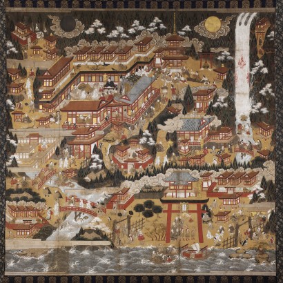
A pilgrimage mandala now at Vassar College shows how that relationship could become a journey for the eye. Dated by the collection to the sixteenth or early seventeenth century, the painting spreads paths, buildings, and figures across a nearly square field. The waterfall descends in a long white band near the right edge. Sun and moon occupy opposite upper corners; the sea establishes a different edge below.[14]
The collection's interpretation follows a white-clad pilgrim couple through the image. Their movement leads from the lower right towards the waterfall and the shrine, then towards Mount Myōhō at the upper left, associated with Amida's Pure Land, a Buddhist realm sought as a destination for rebirth. The same landscape accommodates more than one moment in their progress.
Repetition does the work that a line with an arrow might perform on a modern diagram. The figures reappear, so their several positions need not represent several different groups arriving simultaneously. A viewer follows an unfolding visit within an image that remains physically still. The Japan Tourism Agency's discussion of another Nachi mandala explicitly identifies this repeated couple as a way of representing successive moments.[15]
That convention makes the picture useful without making it a measured route map. A path can connect two painted episodes while the artist compresses the ground between them. Buildings, sacred stories, and acts of worship can be brought into one field because the purpose is to make the place intelligible as a religious destination.
This also gives “mandala” a different local use from the one encountered in Kōyasan's pagoda. At the Garan, sacred figures organize an architectural interior. At Nachi, recognizable terrain and the actions of pilgrims organize a painted world. The term can connect the representations without making their arrangements identical.
6. The mountains could travel in the other direction
Another Nachi mandala, held by Kokugakuin University Library, retains the marks of being folded in both directions. The library associates those traces with its use by religious intermediaries, including the travelling women known as Kumano bikuni. They carried images for etoki, the explanation or deciphering of pictures before an audience.[16]
A fold makes a large religious landscape portable. Opened out, the painting can offer paths, stories, and figures for attention. Folded, it can leave the mountain in someone's keeping. The material treatment joins two activities: presenting a place and taking that presentation somewhere else.
Wakayama Prefectural Museum identifies these travelling women as bearers of Kumano images and amulets. Their explanations brought the sacred region into contact with people away from its shrines.[17] The direction of movement had reversed. Instead of waiting for everyone to make the long approach, religious practitioners carried something of the destination towards an audience.
The work also had an institutional connection. In her study of Kumano's travelling nuns, Chihiro Saka describes religious establishments called honganjo that organized fundraising and construction-related work. Authorized itinerants were expected to return with contributions, obtain supplies, and renew permission for their activities. Her account distinguishes them from personnel who remained in the mountains to administer local tasks.[18]
The picture therefore belonged within a relationship that could continue after one performance. Contributions had somewhere to go; a travelling practitioner had an institution to which to return. The route of an offering was not identical to the route shown in the painting, but both connected an audience with the mountain religious world.
This is a more specific finding than the claim that images made Kumano famous. The surviving fold marks establish portability; institutional accounts identify an activity; research describes a framework of authorization and return. They explain how a connection could work, without supplying a census of everyone persuaded to travel or give.
7. Connections did not remove every boundary
The prominence of a woman in the painted pilgrimage deserves attention alongside the women who carried religious images. It does not establish that every sacred centre connected by these roads applied identical rules of admission.
Kōyasan's own history of its nyonindō, halls for women, recalls chapels at the mountain's seven approaches during the period when women were excluded from entering the central precincts. The surviving hall marks a form of worship organized at a boundary.[19] Religious attachment to a mountain and access to its interior were different relationships.
That contrast prevents the connected landscape from becoming a claim of uniform openness. The road could lead towards several centres while the terms of approaching each remained local and historically changeable. A woman represented walking through Nachi cannot simply be moved into every space at Kōyasan as though the painting were a general admission document.
Nor does the boundary make her religious role disappear. The evidence for travelling Kumano women includes explanation, material custody, fundraising, and links with institutions. They could help bring a sacred place into other people's lives without being merely anonymous figures following a path.
The landscape is richer when these different positions remain visible. A resident, a visiting pilgrim, a person restricted to a threshold, and a travelling religious intermediary do not all encounter the mountains in the same way. Connections among places create opportunities for movement; they do not decide every person's position within each destination.
8. What the direction stone leaves open
Kōyasan's pagoda and mausoleum, the inhabited Kohechi, the Nakahechi's subsidiary shrines, Hongū's displaced river precinct, Hayatama, and Nachi form a landscape with several centres of gravity. Paths connect them physically. Repeated acts give the approaches religious form. Paintings make a particular sacred world portable, while the people carrying them establish further routes of exchange.
The direction stone at Sangenjaya belongs to that world of alternatives. Its message does not appoint one final destination for everyone. It identifies where different choices lead.
That is the essential relationship across these mountains. The places remain particular enough to give a journey more than one purpose. A person can arrive, worship, and still have somewhere else to go; an image can remain recognizable as Nachi even when it has been folded and carried far beyond the waterfall. The sacred landscape holds together through those connections, rather than by becoming one immense enclosure.
Next topic · HO Guides
Naikū: Where the Next Shrine Waits
An alternate building plot, a forester's marked trees, and a carpenter's next assignment reveal the overlapping timescales behind the twenty-year renewal.
Continue readingSources and NotesView sourcesHide sources
Sources consulted 16 September 2026. The geographic scope is Kōyasan, the Kohechi–Nakahechi connection, and the three Kumano centres—not every component of the larger World Heritage property. Historical routes are not supplied as present-day walking instructions.
- [1]
MLIT Kinan River and National Highway Office, Kumano landscape-road record “伏拝王子,” subsection “三軒茶屋跡,” information supplied by 市民の力わかやま, dated 14 December 2009: https://www.kkr.mlit.go.jp/kinan/fukeikaidokumano/kumano/area4/07hong-fusi.html. See the complete subsection and public-domain inscription transcription. The stone's original erection date is not supplied. Historical ri are retained, not converted into present walking distances; unrelated toll-price comparisons are omitted.
Return to the reference ↑ - [2]
Kōyasan Tourist Association, English precinct overview, opening history and entries for Danjō Garan, Kongōbu-ji, and Okunoin: https://www.koya.org/english/. Used for the 816 foundation and differentiated institutional functions, not a claim that the present buildings all date to Kūkai. The assigned landscape is not reduced to the temple currently bearing the name Kongōbu-ji.
Return to the reference ↑ - [3]
Kongōbu-ji, “高野山をめぐる,” “壇上伽藍” and “根本大塔”: https://www.koyasan.or.jp/meguru/. The spatial description follows the temple's account of the central Dainichi, surrounding figures, and painted columns. “Three-dimensional mandala” reports that interpretation; no interior visit or independent iconographic survey is claimed.
Return to the reference ↑ - [4]
Agency for Cultural Affairs, Cultural Heritage Online, “金剛峯寺根本大塔,” record 578705, date, structural fields, and explanatory paragraph: https://online.bunka.go.jp/heritages/detail/578705. It identifies 1937, mixed reinforced/timber construction, and the use of documentary and foundation evidence. No complete design archive or original archaeological report was read.
Return to the reference ↑ - [5]
Kongōbu-ji, interview series, “奥之院と御廟と『維那』の『神秘』にふれる,” interview conducted 20 February 2025, remarks by the Okunoin monk 仁賀大善 concerning living presence and the offerings called 生身供: https://www.koyasan.or.jp/column/. See the interview, especially the kitchen, carrying, and menu-record passages. Used as attributed contemporary religious practice, not proof of an unchanged daily procedure since the ninth century. No video or service was witnessed by this writer.
Return to the reference ↑ - [6]
Tanabe City Kumano Tourism Bureau, “Kohechi”: https://www.tb-kumano.jp/en/kumano-kodo/kohechi/; Kumano Kodo Kohechi Route Maps—Overview, printed pp. 2–3 on one PDF sheet: https://www2.tb-kumano.jp/en/kumano-kodo/pdf/Kumano-Kodo-Kohechi-Route-Maps-Overview.pdf. Overview text and actual map/elevation-profile page image. Used for the connection and alternating mountain/valley terrain, not medieval traffic, an exact founding date, or current trail safety.
Return to the reference ↑ - [7]
Nara Prefecture, historical-cultural resource record 14985, “熊野参詣道小辺路(三浦峠),” entered 27 June 2016, sections “歴史文化資源の概要” and “地域にとって大切な…理由”: https://www.pref.nara.lg.jp/ikasu-nara/bunkashigen/main00109.html. The database identifies its entries as contributions from local stakeholders. Features and remembered pre-highway uses are not all assigned one date; no medieval school journey or identified tea-house transaction is reconstructed.
Return to the reference ↑ - [8]
Tanabe City Kumano Tourism Bureau, “History and Oji,” introduction and entries for Takijiri-ōji and Hosshinmon-ōji: https://www.tb-kumano.jp/en/kumano-kodo/history-oji/. Compare “Hatenashi-toge,” final connection to Sangenjaya: https://www.tb-kumano.jp/en/kumano-kodo/kohechi/hatenashi-toge/. The interpretation distinguishes stages of approach without claiming that every pilgrim visited an identical set. The site's universal-openness assertions and legendary episodes are not adopted as historical proof.
Return to the reference ↑ - [9]
Mitsui Memorial Museum, “熊野御幸記,” collection record 1050, full catalogue description: https://jmapps.ne.jp/mitsui_museum/det.html?data_id=1050. Used only for Teika, Go-Toba, 1201, and the twenty-three-day account. The diary itself was not read, and no individual itinerary, conversation, or observation is attributed to it here. The historical tenth month is not converted into Gregorian October.
Return to the reference ↑ - [10]
Tanabe City Kumano Tourism Bureau, “Kumano Hongu Taisha,” historical introduction, “Oyunohara,” and festival description: https://www.tb-kumano.jp/en/kumano-kodo/world-heritage/kumano-hongu-taisha/. The 1889 displacement, salvaged buildings, 2000 torii, and described ritual return are separate events. The essay reports the festival's institutional description, not an observed performance or an unbroken calendar since the flood.
Return to the reference ↑ - [11]
Tanabe City Kumano Tourism Bureau, “Kumano-gawa River,” opening historical description: https://www.tb-kumano.jp/en/kumano-kodo/nakahechi/kumano-gawa-river/. Supports the downstream pilgrimage connection from Hongū towards Hayatama. Present boat products and schedules are not evidence of the exact form or duration of a medieval voyage.
Return to the reference ↑ - [12]
Tanabe City Kumano Tourism Bureau, “Kumano Hayatama Taisha,” opening description and “Kamikura-jinja”: https://www.tb-kumano.jp/en/kumano-kodo/world-heritage/kumano-hayatama-taisha/. The rock's relation to divine presence is a religious tradition; the source supplies the separate riverside and hillside locations. No supernatural descent or securely dated first foundation is asserted.
Return to the reference ↑ - [13]
Tanabe City Kumano Tourism Bureau, “Kumano Nachi Taisha,” introduction and entries for Seiganto-ji and Nachi Falls: https://www.tb-kumano.jp/en/kumano-kodo/world-heritage/kumano-nachi-taisha/. Used for the local combination of waterfall worship, shrine, and neighbouring Buddhist temple. Traditional foundation dates and exact prehistoric origins are not certified.
Return to the reference ↑ - [14]
Frances Lehman Loeb Art Center, Vassar College, Embodying Compassion, “18. Nachi Pilgrimage Mandala,” object 2004.10: https://pages.vassar.edu/embodyingcompassion/2014/09/29/pilgrimage-18/. Label and full-composition reproduction: https://pages.vassar.edu/embodyingcompassion/files/2015/02/18.-Nachi-Pilgrimage-Mandala-2004.10-cropped-edited-410x410.jpg. The label supplies the broad date and pilgrimage sequence. Visual description is limited to features visible at that resolution; the image is neither a simultaneous crowd scene nor a measured map.
Return to the reference ↑ - [15]
Japan Tourism Agency, “Nachisan Shrine Mandala,” FY2020, R2-00217, “Doctrine and Cosmology” and “Lead Characters”: https://www.mlit.go.jp/tagengo-db/en/R2-00217.html. Its explanation of repeated figures concerns the shrine-held example, not ownership of the Vassar painting. The shared pictorial convention is compared, not the identity of the physical objects. Legendary rescues and universal gender-equality conclusions are not adopted.
Return to the reference ↑ - [16]
Kokugakuin University Library, “熊野那智参詣曼荼羅(掛幅本),” rare-book identifier 貴861, complete descriptive entry: https://opac.kokugakuin.ac.jp/digital/diglib/kumano-k/etc/kaisetsu.html. The catalogue identifies fold marks and portable etoki use; a digitized detail was also viewed, not the original painting. No precise production date or named carrier is supplied. This hanging work is distinct from the library's handscroll 貴2416 and the Vassar object.
Return to the reference ↑ - [17]
Wakayama Prefectural Museum, permanent-display section “祈り,” account of Kumano faith and Kumano bikuni: https://www.hakubutu.wakayama-c.ed.jp/permanent/inori2/08.htm. Used for travelling explanation and the carriage of pictures and amulets, not a quantified measure of conversion, income, or the success of a particular performer.
Return to the reference ↑ - [18]
Chihiro Saka, Mediating between the Religious World and the Masses: Picture Deciphering by the Itinerant Nuns of Kumano, MA thesis, University of Victoria, 2013, pp. 52–56, especially pp. 55–56 and notes 148–151: https://dspace.library.uvic.ca/bitstreams/f10aa9ba-ad81-4c79-9098-5f8109a26b62/download. The relevant institutional discussion was read in the thesis text, not just its abstract. The account reports scholarship on resident/itinerant roles and expected return, supply, and authorization; underlying institutional documents were not independently read. A prescribed return is not proof of universal compliance.
Return to the reference ↑ - [19]
Kongōbu-ji, “高野山をめぐる,” “女人堂,” URL in note 3. Used for the historical boundary chapels and women's exclusion from central precincts, not a single unchanged rule across all centuries or a precise date when every practical restriction ended. The comparison with Nachi separates pictorial inclusion from institutional admission.
Return to the reference ↑