HO Guides
Komine Castle: What the Plans Could Not Decide
A changing seat of government left detailed drawings of its buildings. Recovering the castle required other kinds of evidence too.
Quick · About 2 min
The story in five points
A short route through the argument. Follow a point into Classic for its context and sources.
A working castle recorded its structure
Komine’s 1808 surveys documented hidden timbers as well as outward forms. A separate town map recorded properties and routes. These complementary records helped explain a functioning establishment before they became evidence for reconstructing buildings lost in war.
Read in contextThe city outgrew the recorded arrangement
Ruling households changed before the Boshin War destroyed principal buildings. Railway construction and other uses later occupied former enclosures. Surviving plans could identify those changes, but could not make the whole surrounding landscape reversible.
Read in contextReconstruction recovered documented volumes
The modern timber turret and Maegomon gate used historic drawings and archaeology. Their walls and foundations contained older phases and repairs. The resulting castle made lost spatial relationships understandable without recreating one uniform material date.
Read in contextOrdinary photographs became repair evidence
After the 2011 earthquake, images supplied by residents and researchers helped identify displaced stones and their former positions. Numbering, photographs, and excavation worked together: recovering a wall meant restoring relationships among pieces, not simply reusing local stone.
Read in contextAn apparent gap could be essential evidence
At Shimizumon, contact marks and excavated supports showed that openings in the masonry had accommodated gate timberwork. Repairs retained the gaps. A tidier continuous stone edge would have concealed how the vanished building and surviving wall fitted together.
Read in context
Opening
In 1808, two draftsmen recorded the buildings of Komine Castle. Their work included things a person approaching a gate would never see: the structure beneath its roof and the dimensions of its timbers. The accompanying colophon explained a deficiency in the existing records. The available building drawings came through a family that had previously governed Shirakawa. The castle needed a fuller account of itself.[1]
The new drawings eventually outlived the buildings. When the three-story turret returned to the hill in 1991, it was a timber reconstruction informed by those records and by excavation. The plans had acquired a purpose their makers could not have specified: helping another century recover a castle lost in war.[2]
Yet having a detailed record did not make recovery automatic. Later work would depend on photographs taken without a restoration project in mind, marks left where wood had touched stone, and decisions about whether apparent holes should be filled. What could the drawings preserve—and what still had to be learned from the place they represented?
1. A Castle That Changed Households
Komine stands on a low hill at Shirakawa, a gateway between the Kantō plain and northeastern Honshū. Its major early-modern rebuilding began under Niwa Nagashige in 1629 and was completed in 1632. The project reshaped the surrounding ground as well as the hill. The Abukuma River's course to the north was altered, while stone walls, earthen boundaries, and water separated the castle's enclosures.[3]
This was a substantial rearrangement of a location with an earlier fortified history. A later local chronicle associates a medieval castle here with the Shirakawa-Yūki. That tradition identifies a predecessor, not standing fourteenth-century buildings within the present park. The city's history distinguishes Komine from another Yūki castle several kilometers away.[4]
The early-modern establishment also had more than one layer of enclosure. The honmaru, the principal compound, occupied the central height. Other spaces spread below it, with entrances linking ground at different levels. Stone retaining walls helped make these terraces usable while directing movement through limited crossings. The gate buildings belonged to those crossings: their position was as important as their roofline.[3]
A lord could inherit this arrangement without descending from its builder. Several ruling houses succeeded one another at Shirakawa under the Tokugawa shogunate, Japan's military government. By the time Matsudaira Sadanobu governed there, the Niwa rebuilding was generations old. Responsibility for the castle had passed through people whose tenure was shorter than the life of its walls.[4]
That is the setting in which the 1808 colophon becomes revealing. A usable building and a usable record of it were separate inheritances. Knowing which gate led to the upper enclosure did not tell a carpenter the size of a concealed member. Familiarity with the castle's daily use could coexist with gaps in the information needed to repair it. A new survey could address those gaps without requiring a new castle.
The work was therefore concerned with a functioning establishment, not an archaeological ruin. Its buildings still stood. The remarkable later value of the drawings should not conceal that earlier circumstance: someone had reasons to understand the structure before it disappeared.
2. Two Scales of Knowing the Same Place
Another drawing from 1808 placed the castle within its town. This map used red reference lines running north–south and east–west from the honmaru. It identified retainers at their residential plots, colored the commercial streets pink, and recorded waterways, barriers, guard posts, and moat widths. Its scale was much smaller than that of the building drawings.[5]
The named plots make the map an account of an inhabited administrative center. A castle wall separated spaces, but a household occupied one of them. Water followed a course through the town; a guard post controlled a particular passage. The plan could connect these relationships at a glance in a way that walking from one gate to another could not.
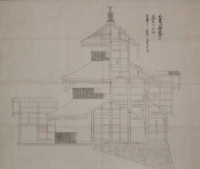
The survey of individual structures answered a different question. Its ground plans were paired with drawings that combined exterior views and cutaway information. The published turret sheet shows the roof profile on one side and the internal arrangement on the other. Instead of choosing between the building as an outward shape and the building as an assembled structure, the sheet presents both.[6]
Such a drawing requires its reader to make a deliberate separation. An outline of a roof is visible from outside; a line identifying an interior member is not. Combining them allows one surface of paper to carry relationships distributed through a three-dimensional object. It is not a picture of a moment when half the turret stood conveniently open.
The city interprets the survey as a likely resource for repairing damaged gates and turrets. Its detailed annotations support that reading, although no particular repair order is reproduced in the catalogue.[1] The distinction between a record's possible use and a documented use leaves the central achievement intact: the castle's fabric had been made available for consultation away from the fabric itself.
Read together, the two sets of drawings offered different kinds of continuity. The town map could preserve an arrangement of properties and routes. The building survey could preserve information about construction. Neither kept a lord in office, guaranteed a household's continued residence, or prevented fire. Their endurance depended on paper surviving changes that the establishments drawn upon it did not survive.
3. The Castle Survived Its Lord's Departure—Then Lost Its Buildings
By the eve of the Boshin War, the Abe rulers had been transferred from Shirakawa. The castle came under direct shogunal control and was entrusted to the administration of the neighboring Nihonmatsu domain. When war reached Shirakawa in 1868, it was therefore not simply the home of a resident lord defending an unchanged hereditary possession. The institutional vacancy preceded the destruction of its principal buildings.[7]
The war accompanied the replacement of the Tokugawa government by the new Meiji state. Fighting over Shirakawa made the castle part of a struggle extending beyond its enclosures; the turret burned during that conflict.[2] The loss changed what could be learned on the hill. A gate's stone supports could remain after the structure controlling passage between them had gone. A defensive boundary might still be recognizable without the building that had supervised its crossing.
After the war, the old castle acquired uses that did not depend on recovering that system. In 1887, the railway and Shirakawa Station occupied part of the former third enclosure. Other outer ground became fields, housing, and public premises. The main area passed through military ownership before transfer to the town in 1893.[8]
The railway makes the change especially concrete. An enclosure formerly defined partly by restricted movement became ground supporting movement through the wider region. Its usefulness as transport land did not require the restoration of castle gates. The town continued to operate around and across a site whose earlier divisions were no longer the sole organizing principle.
The 1808 map now belonged to a landscape with altered routes and occupants. It could identify what had changed; it could not make all those changes reversible. Restoring one turret would not move the station or reinstate the residences named on the map. A modern castle presentation would inevitably have a different extent from the establishment documented under Sadanobu.
This helps explain why the surviving plans are not a command to rebuild everything they show. They preserve information about a former whole. Decisions about what to recover take place in a city that has acquired other needs and other histories. At Komine, the upper castle could become legible again without the entire surrounding town returning to its early-nineteenth-century arrangement.
4. Giving the Upper Castle a Building Again
The three-story turret was reconstructed in 1991; the Maegomon gate followed in 1994. Both used timber and drew on the old plans and archaeological investigation. Their modern dates identify new buildings made to recover documented forms, rather than structures rescued intact from the 1868 fire.[9]
A restored volume supplies information that a plan on a page cannot deliver in the same manner. A stair connects actual floor levels; a roof occupies height above the terrace. The gate turns an opening into a passage beneath a building. These are ways of making the earlier arrangement spatially understandable. Their usefulness does not depend on pretending that the new wood was present during the war.
The buildings also regained a relationship with masonry that had a more complicated material history. The city's castle interpretation identifies an older-looking area around the turret base with an earlier construction phase, while later stonework and repairs occupy other sections. Its proposed dating of that patch precedes Nagashige's major campaign.[9] Even the base beneath a recognizable early-modern form should not be assigned wholesale to 1632.
The result was not a single recovered year. New timber stood above a site containing successive masonry campaigns, and modern paths connected areas whose old buildings had vanished. The drawings helped decide architectural form; they did not make the surviving ground chronologically uniform.
The earthquake of March 2011 exposed another difference between form and material. Stone walls collapsed, and the reconstructed buildings suffered damage to finishes and components. The disaster did not distinguish neatly between what was old enough to be called historic and what had been built to explain history.[10]
Recovering from it required a closer scale of information than the town plan—or even a turret drawing—could provide. The question was no longer only where a wall ran or how high a building had stood. It included which individual stone had occupied which position before the collapse.
5. The Unplanned Archive
The repair team lacked complete pre-disaster photographs of every wall. It appealed to residents and castle researchers for images. Photographs made on other occasions became evidence for matching fallen stones to their former positions. The team numbered and recorded the displaced material, then used the images to recover its arrangement where identification was possible.[10]
This archive differed from the 1808 survey in its origin. The survey had deliberately made hidden structure intelligible. A photograph of a standing wall might preserve details its maker had never intended anyone to study: the outline of one block, a joint, a small change in alignment. After collapse, those incidental details could become the reason the photograph mattered.
A stone could not be returned simply because it was known to have come from Komine. Its neighbors, orientation, and place in the face also mattered. Matching the material to an earlier image restored a relationship, rather than just returning an object to the right property. The strength of the method lay in the connection among several records, not in the age of any photograph considered alone.
Excavation supplied another kind of comparison at the Karamete entrance. Four foundation stones identified during the repair project formed a line corresponding to the eastern pillar positions in the 1808 gate drawing. A stone-lined drain was also found nearby. After investigation and recording, the remains were protected beneath the ground.[11]
The correspondence brought the old survey back into use without allowing it to dominate every finding. The drawing supplied a proposed arrangement; the stones established where supports had actually stood. The drain added evidence of work below the visible gateway. A plan and an excavation could meet at the same location while contributing different information about it.
These investigations made the project more than a return to the wall's appearance on the day before the earthquake. Dismantling and excavation exposed relationships that had been concealed by that appearance. Repair then required deciding how to respond to what had been learned. At Shimizumon, the answer involved leaving something apparently incomplete.
6. Why Some Gaps Had to Stay
Shimizumon linked the second enclosure with the honmaru. Its former gate building had occupied a substantial opening between masonry. During restoration, intermittent gaps in the upper stonework were initially treated as places where stones had disappeared. The proposed repair would have supplied replacements, producing a more continuous upper line.[12]
Closer observation changed the interpretation. Marks below the openings showed where posts had contacted the stone. Their positions corresponded with foundations found in an earlier excavation. The investigators concluded that the openings had accommodated parts of the gate's beam arrangement. Filling them would have removed evidence of the way timber and masonry had fitted together. The walls were restored with the gaps retained.[12]
The choice was small in area but large in consequence. A retaining wall considered by itself might seem to call for a complete stone edge. Considered as the support for a gate, the same edge needed interruptions. The missing-looking material was information about the structure that had once stood above it.
This is where the different records became most useful together. The historic drawing identified a gate rather than an isolated stretch of wall. Excavated supports and contact marks tied its former timberwork to particular positions. The explanation depended on agreement between features whose meanings were less certain when examined separately.
It also reveals a limit to restoration by visual tidiness. An even line would have looked resolved while expressing the wrong relationship. The appropriate repair did not make every part of the castle appear equally complete. It preserved a place for the absent building within the masonry that remained.
At a site repeatedly described through reconstruction, this is a particularly important result. Sometimes the new work required is a replacement structure. Sometimes it is the decision not to insert a replacement stone. Both decisions depend on knowing what the relevant absence means.
7. Another Building, Another Date
The principal earthquake wall-repair campaign reached completion in March 2019. Reconstructing Shimizumon was a separate undertaking. The city's project account, checked on 16 September 2026, still described construction in progress, using the measured drawings and excavation evidence. The proposed gate shown in a reconstruction image was not yet a completed addition to the site.[13][2]
The separation between these projects matters historically as well as administratively. Walls could be stabilized before a lost building returned. Evidence recovered while repairing those walls could then inform the building project. Recovery did not consist of executing one unchanged plan written at the beginning.
Komine's records have acquired responsibilities through such changes. A survey made while the castle operated became evidence after its destruction. A photograph of a wall became useful when the wall fell. A contact mark became an explanation of why a gap should remain. Each preserved something different, and each needed a reader able to connect it with the site.
The castle that results cannot be assigned one material date. Its reconstructed buildings, surviving and repaired masonry, buried foundations, and altered outer enclosures carry different histories. What joins them is more specific than a general wish to make the past visible: a succession of decisions about how particular pieces once worked together. At Shimizumon, the most revealing of those decisions left room for a beam by declining to complete a line of stone.
Next topic · HO Guides
Yamadera: The Mountain Beyond the Verse
Scripture copying, night pilgrimage, and a poet's revisions directed attention toward different things on the same sacred mountain.
Continue readingSources and NotesView sourcesHide sources
Sources were consulted on 16 September 2026. The castle compound remains the main Place; town mapping and transferred administration supply context, not additional assigned sites. Historical Japanese month-and-day entries are not silently converted into Gregorian dates. Construction notices establish dated project status, not future completion or access promises.
- [1]
City of Shirakawa, “白河城御櫓絵図,” paragraphs beginning “白河城御櫓絵図は,” “配置図は,” and “この絵図は,” updated 9 July 2024, https://www.city.shirakawa.fukushima.jp/page/page001379.html. The colophon is reported through the catalogue; the original scrolls were not independently transcribed. Earlier drawings are connected with the former ruling family, not claimed to have been physically borrowed from Kawagoe. Repair use is the city's interpretation.
Return to the reference ↑ - [2]
City of Shirakawa, “小峰城跡清水門を復元しています,” “国指定史跡『小峰城跡』とは,” “小峰城跡清水門とは,” and “復元整備事業の予定(令和8年8月現在),” https://www.city.shirakawa.fukushima.jp/page/page009117.html. Rebuilding, archaeological evidence, and the August 2026 progress statement are kept distinct. The computer-generated image is explicitly a proposal, not evidence of a completed gate. Expected completion is not repeated as fact.
Return to the reference ↑ - [3]
Agency for Cultural Affairs, National Cultural Properties Database, “小峰城跡,” designation explanation, https://kunishitei.bunka.go.jp/heritage/detail/401/00003679. Used for Nagashige's construction sequence, river alteration, and enclosure relationships. No detailed original labor program, hydraulic performance, or private intention is inferred.
Return to the reference ↑ - [4]
City of Shirakawa, “小峰城跡,” historical paragraphs from the medieval predecessor through the ruling-house sequence, https://www.city.shirakawa.fukushima.jp/page/page001390.html. The medieval account is attributed to the later Shirakawa Fudoki. The page's erroneous Gregorian pairing for the 2011 earthquake is excluded; the disaster is documented in note 10. An exact Abe-transfer date is deliberately withheld for the reason in note 7.
Return to the reference ↑ - [5]
City of Shirakawa, “奥州白河城下全図,” catalogue description and scale explanation, https://www.city.shirakawa.fukushima.jp/page/page000430.html. Features and labels follow the catalogue, not an independent transcription of the complete map; the full linked image was not successfully retrieved. A represented property arrangement is not a complete census or proof that every boundary remained unchanged.
Return to the reference ↑ - [6]
“三重櫓建絵図,” reproduced sheet from the 1808 survey, linked in the catalogue in note 1, https://www.city.shirakawa.fukushima.jp/data/img/1453884563_10.jpg. The contrast between exterior and cutaway is a direct, broad observation; small annotations were not independently deciphered and dimensions were not recalculated from the reproduction.
Return to the reference ↑ - [7]
The city's historical account in note 4 gives 1867 for the Abe transfer to Tanagura; its two-page 小峰城 visitor brochure gives 1866, https://www.city.shirakawa.fukushima.jp/data/doc/1766464386_doc_103_0.pdf, first sheet, historical introduction. The essay retains the supported prewar administrative sequence without inventing a decision/departure distinction to reconcile the years. It does not reconstruct the whole regional campaign or assign motives to the transferred lords.
Return to the reference ↑ - [8]
City of Shirakawa, “小峰城跡,” later paragraphs on disposal, railway construction, and transfer of the honmaru to the town, at the URL in note 4. The 1887 railway and station are specifically associated with the former third enclosure. This is a second locator in the same source, not independent corroboration. The interpretation of changing movement through the site is the writer's.
Return to the reference ↑ - [9]
City of Shirakawa, 小峰城, first sheet, “三重櫓,” “前御門,” and “慶長期の石垣,” at the brochure URL in note 7. The earlier masonry attribution remains the brochure's qualified dating. A reconstructed building, retained masonry, and later repair are not treated as one surviving seventeenth-century object.
Return to the reference ↑ - [10]
City of Shirakawa, 国指定史跡 小峰城跡 東日本大震災による被害と復旧状況, issued 30 August 2019, PDF pp. 1–2, particularly “被害状況,” “崩落前の写真収集について,” and the numbered recording sequence, https://www.city.shirakawa.fukushima.jp/data/doc/1504524632_doc_104_0.pdf. These passages support damage, stone identification, and the photographic appeal. Original positions were recovered where evidence permitted, not demonstrated for every stone. No independent structural assessment is made.
Return to the reference ↑ - [11]
City of Shirakawa, “小峰城の石垣―災害復旧で分かったこと (5) 門跡の調査成果,” 広報しらかわ, August 2019, p. 13, “搦手門,” https://www.city.shirakawa.fukushima.jp/data/doc/1564558923_doc_9_0.pdf. The investigators report the foundation correspondence and drain; the original 2013 excavation records were not independently audited. Fire-marked stonework at a different gate on the page is not assigned to the 1868 fire without evidence.
Return to the reference ↑ - [12]
City of Shirakawa, “小峰城の石垣―災害復旧で分かったこと (6) 清水門石垣の復元,” 広報しらかわ, September 2019, p. 13, https://www.city.shirakawa.fukushima.jp/data/doc/1567062621_doc_9_0.pdf. The initial replacement proposal, contact marks, comparison with earlier foundations, and final retention of gaps are the repair team's account. This local detail is not offered as the cause of earthquake failure or as a rule for all castle walls.
Return to the reference ↑ - [13]
City of Shirakawa, “小峰城跡石垣災害復旧工事が完了しました,” completion notice, https://www.city.shirakawa.fukushima.jp/page/page004917.html. The March 2019 masonry completion is separate from the later Shimizumon building project; it does not establish that every future conservation need has ended.
Return to the reference ↑