HO Guides
Matsuyama Castle: Making Room for the Public
A park that closed, a gift accompanied by maintenance money and a palace outlined in water reveal the separate decisions behind a public castle.
Quick · About 2 min
The story in five points
A short route through the argument. Follow a point into Classic for its context and sources.
Public access was repeatedly negotiated
Matsuyama’s summit opened as a park, closed under changing military arrangements, and later reopened. The castle could remain visible from town while inaccessible. Public enjoyment was an instituted use, rather than an automatic consequence of ending domain government.
Read in contextOpening required resources as well as permission
Early negotiations distinguished allowed maintenance income from building-sale receipts. Later paths made the hill reachable, and a donation transferred ownership with maintenance money. Access, ownership, and continuing care were related tasks undertaken at different times.
Read in contextHistoric designation included an occupied city
The designation notice identified schools, a hospital, sports grounds, and former military land within the castle area. These uses were part of its history, not an empty interval between the domain’s departure and modern heritage preservation.
Read in contextA castle outing could change its contents
Animal enclosures, play equipment, shops, a ropeway, and a chairlift supplied different reasons and means to visit. Removing some facilities did not reverse every modern addition. The record establishes changing provisions without assigning every visitor the same motive.
Read in contextDifferent methods made lost structures legible
Reconstructed roofs restored parts of the summit outline. Below, planting and water marked vanished palace divisions around excavated remains. Later clearance and archaeology exposed roads and drains, creating open space through further choices rather than recovering an untouched landscape.
Read in context
Opening
The official notice defining Matsuyama Castle's historic site contains an unexpected list. Among the parcels it names are a baseball ground, tennis courts, a cycle-racing ground, a school, a hospital and an American cultural center. These are not proposed activities for a future park. They identify land included in the designation, in the vocabulary of its existing uses.[1]
The notice joins two maps of the same place. One identifies a former castle, with a keep on a wooded hill and lower enclosures reaching into the city. The other locates institutions and recreation grounds that had occupied parts of it afterward. Preserving the first did not mean the second had never existed—or that naming a historic site instantly removed it.
Matsuyama's conversion into public space followed several such overlapping decisions. The summit opened as a park in 1874, closed in 1886 and reopened in 1910. A later donation transferred the castle to the city. Paths, transport, recreation facilities and archaeological presentation then changed what people could do there.[2] The castle became available through these arrangements, rather than through one irreversible moment when a departing lord left the gates open.
1. A hill with more than one future
Katō Yoshiaki began building Matsuyama Castle in 1602. The project continued beyond his transfer elsewhere in 1627, passing through the Gamō household before the Matsudaira took possession in 1635. Its main enclosure, the honmaru, occupied Katsuyama's summit. The ninomaru, or second enclosure, lay below it, with the sannomaru, the third, extending over lower ground. A change in the use of one part need not determine the use of all three.[3]
The keep standing above them belongs to a later rebuilding, in the middle of the nineteenth century, following the destruction of its predecessor by lightning in 1784. It was a comparatively recent structure when the castle lost its former administrative role. Preserving it did not initially require treating every surrounding space as an exhibition of the distant past.[4]
In 1873, Ehime Prefecture proposed a park on the castle hill. Landscape historian Nonaka Katsutoshi follows the application through surviving official papers. The prefecture emphasized attachment to the castle and the quality of its views. The government asked how the buildings would be maintained. Subsequent arrangements relied on contributions from wealthy local people, with money set aside for continuing care.[5]
A proposed way of raising money encountered a further restriction. The prefecture wanted to sell deteriorating buildings and put the proceeds toward repairs. The 1874 reply did not permit those receipts to become the park's repair fund: sale money was to be remitted to the government. Revenue from dead wood and cut grass could, however, meet park expenses. The distinction concerned which resources the park was allowed to retain, not simply whether its buildings were valued.[5]
The exchange exposed a practical difference between possessing a view and maintaining the structure from which it could be enjoyed. Opening the hill brought the existing buildings into a new undertaking. A roof did not cease to require repair because the people below it were visitors rather than retainers.
The proposed park therefore had two time scales. Admission could begin on an appointed occasion; maintenance had to continue after that occasion was over. The arrangements for money addressed the second problem. They supplied something that an announcement of public enjoyment could not provide by itself.
2. The first park was not permanent
The summit became Jurakuen in 1874. Four years later it hosted an exhibition of products. The prefectural chronology records its opening on 10 April 1878 and its continuation into May. Goods brought to the former castle supplied an additional reason to climb the hill: visitors could encounter a temporary display as well as the tower and the prospect.[6]
An exhibition changed the relationship between the city and the summit without changing the mountain's height. The castle received things selected to be looked at. The undertaking depended on bringing those things together and making them available for a limited period. A place formerly associated with a territorial ruler could accommodate an event organized around products from a wider world.
Meanwhile, military use was expanding below. The army acquired the third enclosure in 1877 and sought further ground. Nonaka's reconstruction of the negotiations shows the difficulty created by the public hill above military premises. Army possession of the whole area and continued public access were not treated as automatically compatible. Agreement over replacement park land eventually preceded the closure.[7]
In 1886 Jurakuen ceased to operate. The former castle remained, but an established public use could be withdrawn. That outcome is particularly important at a hilltop site. A townsperson might still see the tower from below while no longer being permitted to make the same ascent. Visibility and access had parted company.
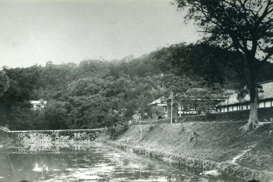
An old photograph of the eastern moat, dated by the castle's custodians to around 1907, preserves that visible relationship. Water and a stone edge occupy the foreground; low buildings stand below the wooded slope, with castle roofs appearing above the trees. The image records no announcement about admission. It shows why the castle could remain part of the city's surroundings during a period when the park was closed.[8]
The first public opening had consequently created neither municipal ownership nor an unconditional right of entry. It had established a use within a changing division of land. When that division changed, the use changed with it.
3. Returning to the hill, then receiving the castle
Matsuyama Park reopened in 1910. New approaches from Furumachi and from behind the prefectural office belong to the same reopening period. They joined the hill to particular parts of the town, adding practical connections to the renewed permission to visit.[9]
For a public mountain, an approach is part of the facility. Its starting point determines where someone can begin the climb; its continuity turns a visible destination into a reachable one. The new paths did not abolish the slope. They organized ways of crossing it. Their early-twentieth-century history also prevents the present approaches from being mistaken for an unchanged diagram of seventeenth-century defense.
A further change came in July 1923, when Count Hisamatsu Sadakoto, of the former ruling family, donated the castle to Matsuyama City. The castle's account specifies that the gift included forty thousand yen for maintenance.[10]
The sum belonged beside the buildings for the same practical reason that funding had accompanied the nineteenth-century park application. A recipient of old architecture receives future expenses along with something worth retaining. The money acknowledged that continuing responsibility. It does not establish that the fund covered every subsequent repair, or that the gift alone explains all later survival.
The reopening and donation did different work. The first restored a public use. The second changed ownership and supplied resources for care. More than a decade separated them. Public enjoyment was already possible before the city received the gift; becoming the owner did not create that enjoyment from nothing.
Nor did the donation transform every parcel of the wider castle landscape into one kind of municipal property. The city's description of Shiroyama Park still distinguishes city management from land borrowed without charge from the national government.[2] “Public park” describes how the place is used and managed. It need not mean that every part of its ground has followed the same legal path into that use.
This uneven history is visible at the scale of the mountain. A summit visit, a lower enclosure and a piece of national land can belong to one park while retaining different institutional histories. The tower is its clearest landmark, but not a complete account of who made the park possible.
4. The city recorded inside the boundary
The twentieth century altered both the skyline and the ground beneath it. Arson destroyed the small keep and adjoining structures in 1933; air raids caused further losses in 1945. The main keep survived. Below, the third enclosure's army barracks gave way to postwar uses, including sporting and cultural facilities.[11]
The historic-site designation of 1952 belongs within this occupied landscape. Its formal notice, published in 1955 and reproduced in the city's preservation plan, names land through the facilities standing on it. The school and hospital appear in the same long description as the former Twenty-second Infantry Regiment's barracks land. Courts and a baseball ground identify other parcels.[1]
That wording makes the boundary unusually informative. It was possible to designate the remains of an Edo-period castle while describing pieces of the protected area through institutions that did not belong to the Edo period. The location was historically continuous; occupation had changed.
A person entering to play a sport did not need to be making a visit chiefly concerned with castle history. Someone going to a school or hospital had another reason to cross the former military ground. These possibilities follow from the uses named in the notice, without requiring us to invent an individual journey. The same outer landscape could serve activities whose participants had little reason to enter the keep.
The notice thus preserves an intermediate Matsuyama: neither a functioning domain castle nor a cleared heritage precinct. Its modern institutions were not empty space between the end of the old regime and the beginning of restoration. They occupied land, required buildings and established their own connections with the surrounding city.
5. A castle outing could include a zoo
The summit also acquired uses beyond inspecting old fortifications. The city's record of works lists animal enclosures and children's play equipment in the main enclosure in 1952. A ropeway reached Chōjagahira on the hill in 1955. Amusement facilities and shops followed there, and a chairlift opened in 1966. The same record notes the removal of the summit's animal enclosures and play equipment in 1966.[12]
These changes distinguish getting to a place from deciding what should happen after arrival. The ropeway addressed part of the climb. The zoo and playground supplied destinations and activities. Castle buildings could remain the reason the hill was famous while a visit included things unrelated to their former military use.
The relationship also worked vertically. Shops and transport occupied one level; the principal castle compound stood higher. The new facilities connected parts of a sloping site rather than turning the entire mountain into a level recreational ground. A mechanical ascent changed the journey without removing the final relationship among hill, walls and summit.
By the time the zoo installations were removed, the park had already accumulated a history of additions. Removal was another decision about its contents, not the reversal of every modern change. The chairlift's opening in the same year is a particularly clear reminder: one recreational arrangement ended while another means of reaching the castle began.
There is no need to make these choices into a contest between people who appreciated history and people who did not. The surviving record identifies different provisions for a public outing. It does not assign every visitor a motive. What it establishes is that the content of “visiting the castle” changed through decisions about transport and activities as well as about old buildings.
6. Rebuilding one outline, marking another
The skyline took shape through a separate sequence. The Bagu turret was rebuilt in reinforced concrete in 1958. In 1968 the small keep and adjoining corner turrets and corridors were reconstructed in wood. These additions restored connections around the surviving main keep, but did not acquire its nineteenth-century fabric by standing beside it.[13]
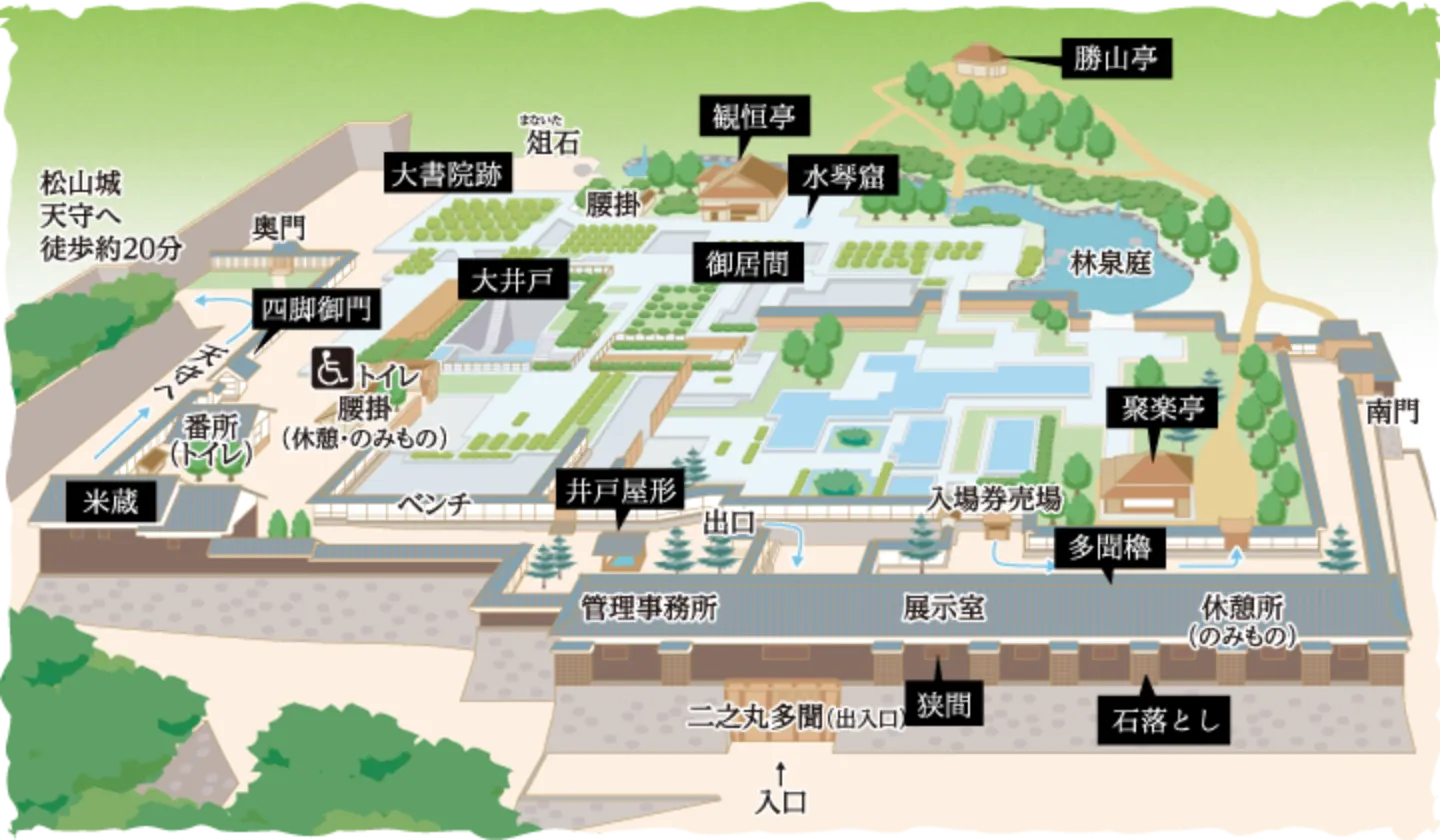
At the ninomaru below, the missing palace received a different treatment. After the school occupying the site moved in the early 1980s, excavation preceded the creation of the historic garden, which opened in 1992. Archaeological investigation recovered a large well, left exposed as a surviving feature.[14]
The palace itself was not rebuilt room by room above ground. Planting, water, gravel and lawn indicate its former divisions. The public-facing palace area is represented with citrus trees and flowers; the inner residential area uses water and other surfaces. The garden's plan shows rectangular compartments arranged within the enclosure, alongside pavilions, circulation and the well.[15]
This creates a way of looking unavailable inside an intact house. Room divisions can be followed without enclosing every one beneath a roof. Water occupies a place where water was not the room's original furnishing. The device asks the visitor to read an outline rather than mistake the garden for a surviving domestic interior.
The surrounding buildings add another layer of interpretation. The operator describes the long turret's exterior as based on Meiji-period photographs and surviving summit turrets. It identifies the reconstructed rice store as modeled on a store at Nijō Castle. That model explains the new building's form; it does not turn it into a Matsuyama storehouse preserved from domain times.[16]
Reconstruction and ground marking therefore offer different kinds of access to absence. At the summit, rebuilt walls and roofs restore an architectural outline. In the garden, an arrangement of open compartments makes a vanished plan legible. The exposed well supplies a third relationship: actual remains retained within a setting made afterward.
7. Clearing ground was another act of making
The larger lower enclosure underwent its own later reorganization. Under a plan adopted in 2000, facilities including the baseball ground, pool, cycle-racing ground and hospital were relocated. Excavation accompanied the work. The first phase, completed in 2010, displayed traces of Edo-period roads and drains within a more open park landscape.[17]
The resulting openness can conceal how much had to move to create it. The old designation notice names a densely used district. Later markings identify an earlier arrangement beneath it. One document records the city that occupied the castle's ground; the presentation now makes selected traces of the castle visible within the city.
Neither is a complete substitute for the other. A marked drain does not explain a hospital's history. A list of postwar facilities does not reconstruct the domain's buildings. Together they identify successive undertakings on ground whose moat and mountain continued to give it a recognizable shape.
Matsuyama's public castle is the result of those undertakings: permission that could be withdrawn, new approaches, a donation with maintenance money, recreational facilities, repaired and reconstructed buildings, and archaeology used to shape open space. The public did not simply inherit a finished park. Different parts were repeatedly made available for different purposes. The surviving keep holds the skyline together; the history of the park explains the changing city below it.
Next topic · HO Guides
Kōchi: The People on the First Page
A book's greeting, a school report and short-lived journals show how people were invited into political discussion before most could enter an electorate.
Continue readingSources and NotesView sourcesHide sources
- [1]
Cultural Properties Protection Commission, Notice no. 59, published 12 November 1955, concerning the historic-site designation dated 29 March 1952, reproduced under “指定告示” in Matsuyama City, 『史跡松山城跡保存活用計画』 (2019), chapter 3, p. 72. https://www.city.matsuyama.ehime.jp/shisetsu/koen/riyou-iji/hozonkatuyoukeikaku.files/Matsuyamajo-05.pdf . See the rendered notice, including the parcels identified with the school, hospital, baseball ground, tennis courts, cycle-racing ground, American cultural center and former Twenty-second Regiment land. The essay interprets this public-domain administrative text's coexistence of historic designation and named uses; it does not independently check every parcel's ownership or imply all facilities were constructed in 1952. Designation and later gazette publication are kept distinct.
Return to the reference ↑ - [2]
Matsuyama City, “城山公園,” updated 9 January 2026, “沿革”, the following national-land-use note, and “松山城・二之丸史跡庭園.” https://www.city.matsuyama.ehime.jp/shisetsu/koen/syoukai/shiroyama.html . Read for the 1874 opening, 1886 closure, 1910 reopening, mountain/lower-enclosure relationship and the city's statement that part of the park occupies national land lent without charge. This source does not establish an unchanged landholding pattern since 1923. The essay supplies no present admission, route-access or operating-hours promise.
Return to the reference ↑ - [3]
Matsuyama Castle, “歴史と人物,” chronology, entries 1602, 1627 and 1635, https://www.matsuyamajo.jp/discover/history.html ; Matsuyama City's 2019 preservation plan, chapter 3, p. 72, opening paragraph, URL in note 1. These identify successive ruling households and the vertically distributed enclosures. Only necessary foundation context is used; no claim about an unsurpassed construction duration, a founder's private motives or a documented siege along present visitor routes is adopted.
Return to the reference ↑ - [4]
Matsuyama Castle, “歴史と人物,” chronology entries 1784, 1820, 1847 and 1854, URL in note 3. The operator places completion in 1854; Matsuyama City’s “松山城年表,” updated 21 April 2025, gives 1852 for the connected keep group: https://www.city.matsuyama.ehime.jp/kanko/kankoguide/shitestukoen/matsuyamajyo/nenpyou.html . The body uses mid-nineteenth-century rebuilding, rather than inventing a framework-versus-completion reconciliation. The surviving tower is not assigned to Katō Yoshiaki's original building campaign. The detailed original construction accounts were not obtained.
Return to the reference ↑ - [5]
Nonaka Katsutoshi (野中勝利), “『廃城』後の城址における公園化の契機と経過,” Landscape Research / ランドスケープ研究 79(5), 2016, pp. 419–424, specifically p. 420, section 2(1). DOI 10.5632/jila.79.419. https://www.jstage.jst.go.jp/article/jila/79/5/79_419/_pdf/-char/ja . See the rendered Matsuyama section and notes page; the article's underlying prefectural papers were not independently examined. Used for the application, maintenance inquiry, local funding and the quoted 1874 distinction between building-sale receipts and revenue from dead wood/grass. Proposed sales are not represented as completed disposals. The explanation of admission and continuing expenses as different tasks is this essay's limited inference. The paper's precise pre-November-1873 ministerial attribution is not adopted, since the ministry's establishment chronology requires separate checking.
Return to the reference ↑ - [6]
『愛媛県史 年表』, 28 February 1989, digitized by the Ehime Prefectural Lifelong Learning Center, 1874, 18 February, and 1878, 10 April entries, respectively citing 『愛媛県紀』 and prefectural notices. https://www.i-manabi.jp/system/regionals/regionals/ecode:2/67/view/8405 . The chronology records permission for the summit park and the exhibition's actual April opening, distinct from an earlier proposed March schedule described by Nonaka. Used at compiled-chronology level, not as an independent reading of the complete original notices or exhibition catalogue. No visitor total, product list or demonstrated industrial benefit is claimed.
Return to the reference ↑ - [7]
Nonaka, 2016, p. 421, section 2(3), “再び陸軍省の所管になり閉園,” URL in note 5, with the opening/closure dates checked against the municipal history in note 2. See the rendered section for military acquisition of the lower enclosure, concern about the overlooking park and negotiations preceding closure. The source's newspaper evidence is not presented as an independently read complete press run. No motive is attributed to individual visitors or a claim made that the castle was demolished when the park closed.
Return to the reference ↑ - [8]
Matsuyama City Board of Education historical photograph, “明治40年頃の東堀,” reproduced in Matsuyama Castle, “歴史と人物,” URL in note 3. Photograph: https://www.matsuyamajo.jp/assets/images/pages/history04.webp . The custodian's approximate 1907 date is retained. Water, masonry, lower buildings, trees and upper roofs are qualitative observations of the photograph. The photograph itself does not prove access rules, identify every building or establish an exact view point or date.
Return to the reference ↑ - [9]
Matsuyama Castle, “歴史と人物,” 1910 and 1911 entries, URL in note 3; Matsuyama City, “城山公園,” “沿革,” URL in note 2. The operator dates the opening of the prefectural-office rear approach and Furumachi approach to 1911, while the city groups their creation with reopening in 1910. The essay uses the reopening period rather than assigning an unsupported start/completion sequence. It does not infer exact historical grades, trip times, route widths or universal accessibility.
Return to the reference ↑ - [10]
Matsuyama City, “松山城寄贈100周年記念イベントを開催します,” 12 July 2023, “目的” and “寄贈,” https://www.city.matsuyama.ehime.jp/hodo/r5/202307/ibentokaisai.html ; Matsuyama Castle, “歴史と人物,” “久松定謨,” URL in note 3. The city identifies the donation in July 1923; the castle identifies 40,000 yen accompanying it for maintenance. The latter's unsourced modern-value conversion and celebratory explanations of character are omitted. The donation deed, full property schedule and subsequent fund accounts were not inspected; the essay does not claim that this was the source of every later repair payment.
Return to the reference ↑ - [11]
Matsuyama Castle, “歴史と人物,” chronology entries 1933 and 1945, URL in note 3; Matsuyama City, “城山公園,” “堀之内地区(三之丸跡ほか),” URL in note 2. Used for the different episodes of destruction and the lower grounds' army/postwar uses. The operator page's erroneous two-building figure in its 1950 entry is not used. Destruction, survival and later reconstruction remain separate processes; no evaluation of wartime or postwar policy is offered.
Return to the reference ↑ - [12]
Matsuyama City, 2019 preservation plan, chapter 3, p. 76, table 18, 1952, 1955, 1956 and 1966 rows, URL in note 1. It locates animal enclosures/play equipment at the honmaru, ropeway and later amusement facilities at Chōjagahira, and the 1966 removal/chairlift entries. The essay draws no attendance figures or visitor attitudes from this works chronology. It does not confuse this summit zoo with the separate zoo formerly in Dōgo Park, or claim that ropeway users arrived directly inside the keep.
Return to the reference ↑ - [13]
Matsuyama Castle, “歴史と人物,” 1958 and 1968 entries, URL in note 3; 2019 preservation plan, chapter 3, p. 75, section 3, URL in note 1. The sources distinguish reinforced-concrete reconstruction of the Bagu turret from wooden reconstruction of the small keep and connected structures. No claim is made that every reconstructed component reproduces a measured original or that all buildings visible together have the same age. The plan's separately corrected building table is not used to assign additional construction dates.
Return to the reference ↑ - [14]
Matsuyama City, 2019 preservation plan, chapter 3, p. 75, section 3, URL in note 1. Used for the school's departure, subsequent excavation, works and 1992 garden opening. The prose gives 1983 for school relocation, while the works table elsewhere uses 1982; the body says early 1980s, without inventing separate moving stages. The well's possible Katō-period attribution is not made certain. The full excavation report was not obtained; the interpretation does not depend on the coin-related romance promoted in other local accounts.
Return to the reference ↑ - [15]
Matsuyama Castle, “二之丸史跡庭園の紹介,” opening explanation and “二之丸御殿の構成,” https://www.matsuyamajo.jp/guide/ninomaru.html . Modern plan: https://www.matsuyamajo.jp/assets/images/pages/ninomaru-map.webp . The operator identifies citrus/flower planting and water/gravel/lawn as representations of former room divisions. Visual remarks concern the modern interpretive plan, not an independently measured Edo-period palace drawing. The article's comparison of open ground marking with an enclosed house is architectural reasoning; the planting and water are not described as surviving palace furnishings.
Return to the reference ↑ - [16]
Matsuyama Castle, “二之丸史跡庭園の紹介,” “多聞櫓” image captions and “米蔵” caption, URL in note 15. These explicitly identify the use of Meiji photographs/summit turrets and the Nijō Castle rice-store model. They support a distinction between a reconstruction's model and original fabric, not a claim that an original Nijō building was moved to Matsuyama. The essay does not reconstruct a detailed Edo-period household routine from these modern interpretive buildings.
Return to the reference ↑ - [17]
Matsuyama City, “城山公園,” “堀之内地区(三之丸跡ほか),” URL in note 2; 2019 preservation plan, chapter 3, p. 75, URL in note 1. Used for the 2000 plan, relocation of named facilities, excavations and 2010 first-phase completion. The city's account specifies presentation of Edo-period roads and drains. The essay does not endorse a current planning proposal, imply all modern institutions have left the site or promise completion of later work. The contrast with the 1955 notice is a comparison of two documented stages, not a complete parcel-by-parcel land-use history.
Return to the reference ↑