HO Guides
Ichi-no-Tani: A Battle Wider Than Its Name
A courier's report, a disputed mountain route and a coast that offered escape recover the different scales of an 1184 defeat.
Quick · About 2 min
The story in five points
A short route through the argument. Follow a point into Classic for its context and sources.
The battle extended beyond one famous slope
Ichi-no-Tani belonged to a coastal front reaching east toward Fukuhara and Ikuta. Western narrow ground, inland ridges, and maritime routes posed different problems. A descent story cannot explain the whole defeat or the survival of people escaping by ship.
Read in contextContemporary news was hurried and incomplete
Kanezane’s diary records reports of different commanders attacking from coast and mountains. It also preserves uncertainty about casualties and the imperial regalia. A contemporary account of incoming news is valuable without turning every initial assertion into a settled result.
Read in contextLater texts construct different mountain journeys
The Heike develops guides, tests with horses, obstacles, and renewed advances. Azuma kagami gives a different account and force size. Their later formation and possible textual dependence prevent agreement from automatically becoming independent confirmation.
Read in contextThe exact descent remains disputed
Modern Hiyodorigoe and the western stronghold occupy different positions along the front. Scholars connect textual and geographical evidence differently. Neither standing on a steep slope nor tracing later roads resolves which force took a particular medieval route.
Read in contextEscape and remembrance selected different outcomes
The Heike distinguishes reaching shore, boarding, and leaving; Antoku and Munemori survived beyond the defeat. Atsumori’s encounter and later memorials focus attention on one casualty. Their traditions should not erase either the wider retreat or their own later commemorative dates.
Read in context
Opening
Before dawn on the day after the fighting, news reached the court minister Kujō Kanezane in Kyoto. A message from the warrior Kajiwara Kagetoki had arrived during the night, reporting the destruction of the Taira. Around midday, a visitor brought further details. Kanezane entered them in his diary: attacks from different directions, positions taken, people supposedly killed. Yet the names of the dead had not arrived, and the fate of the imperial regalia remained unknown.[1]
The entry concerns the battle now called Ichi-no-Tani, fought in 1184 across the coastal corridor occupied by modern Kobe. Its mixture of triumph and missing information is striking. The news had traveled faster than a complete account of whom the victory had actually reached.
At Suma, the western part of this battlefield, mountains approach the sea. The landscape is closely associated with Minamoto no Yoshitsune's celebrated descent upon the Taira from above. But a single downward arrow cannot contain everything in Kanezane's report. The battle involved a coastal front, several attacking groups and people who escaped by ship. Recovering those relationships makes the western ground more intelligible without requiring one slope to explain the entire defeat.
1. The narrow end of a long position
Ichi-no-Tani lay near the old boundary between Settsu and Harima, provinces along the Inland Sea. The later military chronicle Azuma kagami places a Taira stronghold at that boundary. The mountain-and-coast setting fits the western Suma sector, where the ground narrows below Hachibuse and Tekkai. Farther east lay Fukuhara and the Ikuta area. These were parts of a wider battlefront, not alternative names for one small fort.[2]
A position here had different edges. Along the coast, an approaching force could be confronted where the strip of usable ground contracted. Inland, ridges and valleys complicated movement toward the shore. Seaward, boats supplied a connection beyond the ground being defended. Keeping a land approach closed and keeping a maritime route available were compatible purposes.
That combination mattered to the Taira, a warrior house whose fortunes were joined to an imperial household. After leaving Kyoto in 1183, they continued to carry the child emperor Antoku. By early 1184 they were again at Fukuhara, closer to the capital. Kanezane's entry of the fourth day of the second lunar month records a report that they had brought the emperor there and intended to return to Kyoto.[3]
The proposed return was still a report about the future. Within days, the forces of Minamoto no Noriyori and his brother Yoshitsune attacked. Their approach put pressure on a position intended to sustain further action, rather than on the last surviving vessel of an already extinguished court.
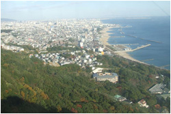
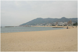
The modern coast preserves the larger physical relationship more readily than the wartime boundaries. The Hyōgo Prefectural Museum of History's photographs show wooded slopes descending toward a densely built shore; engineered coastal edges intervene between the sea and parts of the urban ground.[4] This is not the unchanged frontage of 1184. It is still a setting in which a journey along the coast differs substantially from a journey across the hills toward it. Those directions recur in the written evidence.
2. Three attacks in a minister's diary
Kanezane's account gives Yoshitsune, Noriyori and a third commander, Tada Yukitsuna, different places in the report. Yoshitsune was said to have taken a position in Tanba, then Ichi-no-Tani. Noriyori had attacked Fukuhara from the coastal side. Yukitsuna had approached from the mountains and taken the mountain-side position first.[1]
The names do not simply multiply the credit for one action. They divide the field into relationships: one movement followed another, one approach came along the coast, another came from high ground. The report locates victory through several undertakings rather than through a single commander occupying every point on a modern map.
Its language also preserves the way the information arrived. Messages from the commanders were retold to someone in the capital, then written into a diary. Kanezane was not observing the battle from a hill above Suma. His entry contains both assertions and indications of what had not yet been confirmed.
The missing names are particularly important. A statement that the Taira had been destroyed did not establish the fate of every member of the family. The report even speculated about the death of their leader Munemori. Its closing acknowledgment that the regalia's fate was still unknown leaves the political result incompletely described. Military success and the recovery of the objects associated with imperial succession were separate questions.
The entry does not narrate Yoshitsune's famous mounted descent. Nor does it give Yukitsuna's mountain approach an exact modern location. What it supplies instead is a contemporary record of differentiated actions and hurried news. Its usefulness does not depend on promoting every detail of that news into a settled finding.
Reading the report beside the western terrain changes the question. Rather than looking only for a place from which Yoshitsune could have ridden down, we have to ask how taking a western position related to pressure on Fukuhara and to a mountain attack attributed to someone else. A plausible answer has to accommodate the rest of the battlefield, not make it disappear behind the famous maneuver.
3. How the mountain became a route
The Tale of the Heike supplies a much fuller journey. In its account, Yoshitsune divides his force, sending men toward the western entrance while taking another group through the mountains. The warriors ask for a guide. One boasts that a capable fighter knows the rear of an enemy's stronghold; another suggests following an old horse. A hunter eventually explains the terrain, and his son becomes their guide.[5]
This sequence makes finding the approach part of the action. The mountain is not empty ground across which an arrow on a map can be drawn without difficulty. The narrative raises questions about knowing a way through it, judging its obstacles and reaching the appropriate side of the defenses.
In the following descent episode, horses are sent down first. Some fall or are injured; others reach the bottom. Yoshitsune leads riders after them. The movement then pauses on a ledge above another steep section, until Miura Yoshitsura advances, comparing the ground with the terrain familiar to him at home.[6]
The descent has stages: an uncertain approach, a test, a first movement, another obstacle and a renewed advance. It is not an uninterrupted leap from a mountaintop into the sea. The narrative turns difficult ground into a sequence of decisions that its characters can take.
The Azuma kagami also places Yoshitsune on a mountain behind Ichi-no-Tani, called Hiyodorigoe, and associates Miura Yoshitsura with the attack from difficult ground. It does not supply the same extended testing sequence. Its chosen band numbers seventy-odd riders; the Heike version read here gives the descending force thousands.[2][6]
Those are different textual representations, not two measurements to average. Both works took shape after the battle, and the relationship between their narratives complicates any claim that agreement automatically supplies independent confirmation. The court diary, the chronicle and the war tale each preserve something different: incoming reports, an organized military account and an elaborated journey through danger.[7]
The tale's topography is nevertheless purposeful. Its steepness explains why an approach might be unexpected; its pauses make passage through that steepness dramatic. It gives the mountain a place in the defeat. What remains to be established separately is where that literary route belongs on the actual coast.
4. Two mountains behind one name
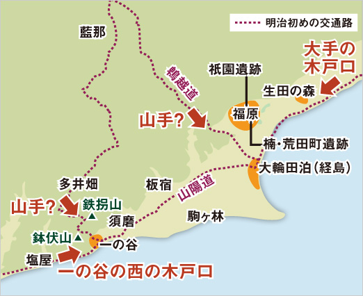
The name Hiyodorigoe creates a problem before anyone attempts to reconstruct the riding. The route bearing that name in Kobe lies well east of western Ichi-no-Tani, toward Fukuhara. The museum's discussion puts the separation at roughly seven to eight kilometers. Its interpretive map marks possible mountain attacks near both locations, each with a question mark.[4]
The distinction changes what “behind” means. Behind the western stronghold would put an attacker on the slopes above Suma. Behind Fukuhara would bring a force toward a more central part of the Taira position. These are different relationships with the coastal front, even though both involve coming from the mountains.
Historian Kondō Yoshikazu argues for the western setting. He emphasizes the Azuma kagami's placement of the stronghold at the Settsu–Harima boundary and reads its rear mountain as Hachibuse or Tekkai, rather than the present Hiyodorigoe route. The prefectural museum's discussion gives more weight to a central attack: a short reported battle spread over a long frontage, it suggests, is easier to explain through pressure near Fukuhara. It leaves the identity of that attacking commander unresolved.[8][9]
The disagreement concerns how pieces of evidence should be joined. The boundary reference anchors a particular stronghold. The broad front and reported duration raise questions about how the fighting developed across it. Neither supplies a continuous record of troop movements. The diary's approximate time report cannot bear the precision of a modern operational log.
The museum's map adds a useful caution of its own. Its dotted routes are labeled as roads of the early Meiji period, centuries after the battle. They help orient the reader among places; they are not presented as a surviving medieval campaign map.[4]
Standing on a steep slope would settle neither the meaning of the old place-name nor the path taken by a particular force. The geographical gain comes from retaining both scales: the western bottleneck and the longer defended corridor. The first explains why Ichi-no-Tani mattered. The second prevents a local explanation from silently becoming an account of the whole battle.
5. Reaching the water was another problem
The sea changed its role as the land positions collapsed. In the Heike's descent chapter, fire and the approaching enemy drive people toward boats. The vessels are available, but passage aboard them is contested. The narrative describes overcrowding, sinking boats and people being refused entry. Its reported numbers are not a reliable passenger inventory; its sequence makes access to a boat a separate struggle from reaching the beach.[6]
Another chapter follows Moromori, a young Taira family member, into a small vessel. An armored retainer jumps aboard, overturning it. Moromori is pulled from the water and killed. Later in the same chapter, the emperor and other members of the household leave by ship, with vessels described along several coastal and island routes.[10]
The contrast does not require treating each literary incident as an independently verified death report. It distinguishes outcomes that the phrase “retreated by sea” can conceal. Someone might reach the shore, reach a vessel, leave the immediate fighting or regain contact with other survivors. Those are successive possibilities, not one guaranteed escape.
Atsumori's encounter with Kumagai Naozane begins within this same interval. In the Heike, Atsumori has already ridden into the water toward an offshore boat when Kumagai calls him back. The ensuing fight occurs at the water's edge. Kumagai kills him, then finds a flute among his possessions. The narrative eventually supplies the young man's name.[11]
The shoreline is indispensable to the episode. It is the space between imminent departure and renewed contact with an enemy ashore. Removing the boat would change the encounter's beginning; removing the retreat would change why the two men meet there. The famous personal story is attached to a larger movement out of the collapsing positions.
The continuing imperial household also explains the incompleteness of the first victorious report. Antoku and Munemori survived Ichi-no-Tani. The destruction of the Taira's position here did not bring the entire traveling court into the victors' hands. That difference left the war with a further maritime history, rather than an ending on this beach.[12]
6. A roadside monument and a temple's collection
Near the western coast, Atsumori-zuka gives one of the battle's dead a durable address. The large stone monument is a gorintō, a five-part Buddhist funerary tower. Kobe's archaeological center dates its surviving fabric to the late Muromachi–Momoyama period, long after 1184. The prefectural museum places it beside the old San'yō road.[13]
Its roadside setting makes a different relationship with movement. People traveling along the coastal corridor could encounter a named memorial rather than a defended entrance. The tower makes the dead warrior's association with the coast visible. Its material date identifies an act of later commemoration, not a stone left standing from the day of the battle.
Sumadera, inland from the shore, distributes the story among several named places. Its account identifies an Atsumori head mound, a pond associated with washing his head, and a pine associated with Yoshitsune's inspection. It distinguishes its head mound from the coastal monument, which its tradition associates with the body.[14]
These identifications turn the aftermath into a sequence that can be located within a temple landscape. They should be read as the temple's commemorative account, rather than as independently authenticated locations of each action or confirmation of what lies beneath either mound. The two monuments are not interchangeable simply because they share Atsumori's name.
The temple also preserves flutes attributed to him. Its account identifies two instruments and gives the larger, Aoba, a transmitted history through religious and courtly ownership. The Heike text read here names Atsumori's flute Saeda and gives its own lineage. The essay need not invent a reconciliation between these accounts to recognize what they share: an instrument makes the defeated youth recoverable as a musician as well as a casualty.[15]
Here the battle's scale contracts again, but for a different purpose from locating a decisive attack. A name, a bodily memorial and a musical object give attention a particular focus. The wider campaign did not disappear when those associations formed. It became easier to remember through one person whose story could be attached to the places people continued to use.
7. What the western ground explains
Ichi-no-Tani's surviving evidence works at several distances. Kanezane's diary receives a battle from afar, with victory announced before all its consequences are known. The Heike brings readers onto a mountain path and into the interval between shore and boat. Modern geographical interpretations ask how those accounts fit a long coast. The monuments concentrate remembrance at places where a person can stop.
Keeping the distances distinct produces a more useful understanding than finding one viewpoint from which everything supposedly becomes visible. At Suma, the narrow ground helps explain a western defensive position. The mountains make an approach from inland a different undertaking from one along the shore. The sea allows the loss of a land position to coexist with the survival of people who leave it.
The exact descent remains disputed. The larger relationship does not depend on resolving every turn of that route: Ichi-no-Tani belonged to a battlefront wider than its name, and its fall was not the capture of every person the Taira were protecting. The coast preserved both the site of a defeat and a way beyond it. Its later memorials give the dead places to remain, while the records still require us to account for those who got away.
Next topic · HO Guides
Shiki's Matsuyama: Learning to Judge a Poem
A reconstructed childhood room and manuscripts of other people's verses reveal the practical work behind a poet's literary reform.
Continue readingSources and NotesView sourcesHide sources
- [1]
Kujō Kanezane, 『玉葉』, second lunar month, eighth day, 1184, the battle-news entry, reproduced in Japanese reading order by Kondō Yoshikazu, “一ノ谷合戦,” Kobe City Archives, PDF p. 2, “1.『玉葉』にみえる一ノ谷合戦,” “原文と要約.” https://www.city.kobe.lg.jp/documents/60534/tokusyu-genpei-3.pdf . The entry reports the overnight message via Fujiwara no Norisue and a midday account by Sadayoshi; names and titles are reduced in the body to avoid obscuring the information chain. Its statements about near-total destruction and Munemori are reports or speculation, not accepted casualty findings. The edition labels the year Genryaku 1 retrospectively; the article uses 1184 and the lunar date without converting it to Gregorian February. No original diary manuscript was inspected.
Return to the reference ↑ - [2]
『吾妻鏡』, second lunar month, fourth, fifth and seventh days, 1184, selections reproduced in Kondō, PDF p. 3, “2.『吾妻鏡』にみえる一ノ谷合戦,” “原文と要約,” URL in note 1. They locate the stronghold at the Settsu–Harima boundary, name the two principal commanders, describe Yoshitsune's selected party and difficult rear approach, and distinguish horse and boat withdrawals. Kondō marks omissions; this is not a claim to have read the full entries in an independent critical edition. Force totals are compared only as features of the texts, not adopted as verified headcounts. The geographical identification is discussed separately in notes 4 and 8.
Return to the reference ↑ - [3]
『玉葉』, second lunar month, fourth day, 1184, quoted entry on Kondō, PDF p. 2, URL in note 1. The report places Antoku with the Taira at Fukuhara and reports an intended return to Kyoto. The departure from Kyoto in 1183 and return to Fukuhara are summarized in Kondō, PDF p. 1, “合戦前の動向.” Neither the reported intention nor the accompanying army estimates is treated as a fulfilled plan or verified force comparison. The essay supplies only context needed to understand the coastal position, not a complete history of the rival imperial courts.
Return to the reference ↑ - [4]
Hyōgo Prefectural Museum of History, “ほんとうの一の谷合戦,” “坂落としの位置,” and associated modern interpretive map “生田森・一の谷周辺.” Text: https://www.hyogo-c.ed.jp/~rekihaku-bo/historystation/rekihaku-meet/seminar/etoki/truth.html . Map: https://www.hyogo-c.ed.jp/~rekihaku-bo/historystation/rekihaku-meet/seminar/etoki/ext/obj/img/map_a3_2.jpg . The map labels roads as 明治初めの交通路, and marks 山手? in two locations. It is not an 1184 survey. The source's approximate seven-to-eight-kilometer separation is retained as such. See the paired photographs “須磨一の谷” and “須磨浦”, respectively https://www.hyogo-c.ed.jp/~rekihaku-bo/historystation/rekihaku-meet/seminar/etoki/obj/img/c2_img4.jpg and https://www.hyogo-c.ed.jp/~rekihaku-bo/historystation/rekihaku-meet/seminar/etoki/obj/img/c2_img6.jpg . The essay's visual remarks are limited to the broad slope, settlement and engineered-shore relationship; no medieval shoreline, gradient or troop route was measured.
Return to the reference ↑ - [5]
『平家物語』, Book IX, “老馬,” original-language text in 日本古典文学摘集, particularly the division of forces and guide-seeking passages beginning “同じき六日の曙に” and “ここに武蔵坊弁慶.” https://www.koten.net/heike/gen/134/ . See the chapter, including the hunter's warning and appointment of his son. Its dialogue, local knowledge and animal guidance are treated as narrative features, not authenticated conversations or proof of an actual guide's itinerary. This is an electronic presentation of the classical text, not collation of all Heike manuscripts; the site's modern-Japanese translation was not used for an English quotation.
Return to the reference ↑ - [6]
『平家物語』, Book IX, “坂落,” original-language chapter, especially the horse test, ledge, Miura's advance, burning buildings and embarkation passages. https://www.koten.net/heike/gen/137/ . The terrain, numbers, speeches, weather and casualties belong to the literary account; numerical heights, the amplification of voices and boat capacities are not presented as measurements. The reading Yoshitsura / よしつら is confirmed under 佐原義連 in Kanagawa Prefecture, “三浦一族に関する人物紹介”: https://www.pref.kanagawa.jp/docs/d2t/kanko/p632176.html . That profile is used only for the name reading; no judgment of skill or character is inferred from the narrative. Interpretation concerns the sequence in which the text makes passage possible.
Return to the reference ↑ - [7]
Kondō, “一ノ谷合戦,” PDF p. 1, “一ノ谷合戦を考えるための文献資料,” URL in note 1, on the later compilation of Azuma kagami and the proposed dependence of parts of its account on the Heike. This is a warning against assuming independence, not proof that every passage was directly copied. The present comparison uses only the separately identified diary excerpts and narrative chapters; it does not reconstruct the full textual genealogy or adopt every judgment in Kondō's essay.
Return to the reference ↑ - [8]
Kondō, PDF pp. 4 and 7, “『吾妻鏡』の解釈” and “義経軍と行綱軍の動向,” URL in note 1. These passages argue from the provincial boundary and the stronghold's rear to a western Hachibuse–Tekkai setting. Read as an attributed geographical interpretation, not a proven route. His hypothetical division of Yoshitsune's army, Yukitsuna's possible guiding role, comparison with later European cavalry exercises and sweeping claims about what trained horses can do are not adopted.
Return to the reference ↑ - [9]
Hyōgo Prefectural Museum of History, “ほんとうの一の谷合戦,” “坂落としの位置,” concluding paragraph beginning “現在のところは、どの説がよいのか,” URL in note 4. The museum considers a central Hiyodorigoe attack in relation to the long front and short reported duration, while acknowledging unresolved command and possible western action. The present essay reports that reasoning without presenting the conclusion as settled or converting traditional time divisions into a precise stopwatch chronology. The museum's separate allegations concerning pre-battle diplomatic deception are outside this essay's argument and are not adopted.
Return to the reference ↑ - [10]
『平家物語』, Book IX, “落足,” complete original-language chapter, especially Moromori's overturned boat and the departure passage beginning “軍敗れにければ主上を始め参らせて.” https://www.koten.net/heike/gen/143/ . Used as literary representation of uneven escape and dispersal. No particular drowning mechanism, exact age, casualty figure, destination of every vessel or emotion of every survivor is independently certified. The distinctions among reaching shore, boarding and leaving are this essay's analysis of the narrated sequence, not a new quantitative model of medieval evacuation.
Return to the reference ↑ - [11]
『平家物語』, Book IX, “敦盛,” complete original-language chapter, from the opening approach to the sea through identification and the flute's transmitted history. https://www.koten.net/heike/gen/141/ . The text places the mounted warrior already in the water before Kumagai calls him back; the body preserves that sequence rather than reducing it to a duel begun on dry land. Final speeches, private thoughts and details of killing remain explicitly narrative. The text's claim linking the episode to Kumagai's religious awakening is not turned into a verified single-cause biography.
Return to the reference ↑ - [12]
Kondō, PDF p. 5, “宗盛の返書,” opening account of Munemori at Yashima after the defeat and a demand for Antoku and the regalia, URL in note 1; compare the emperor's departure in the Heike passage in note 10. Used only for the survival of the household beyond Ichi-no-Tani. The chronicle places the transmitted reply in an entry earlier than its own stated date; no exact dispatch/receipt date or speculative correction is used. The letter's accusations are not used to assign a private motive, justify either side or decide responsibility for the outbreak of the battle.
Return to the reference ↑ - [13]
Kobe City Archaeological Center, “敦盛塚,” object identification and 時代 field. https://www.city.kobe.lg.jp/culture/culture/institution/center/spots/suma/atumori.html . Its supplied photograph: https://www.city.kobe.lg.jp/culture/culture/institution/center/spots/SMALL/1485-02.jpg . The center dates the stone tower to late Muromachi–Momoyama. Hyōgo Prefectural Museum of History, “名所めぐり:敦盛塚,” identifies the San'yō-road setting and distinguishes a founder tradition from stylistic dating: https://rekihaku.pref.hyogo.lg.jp/digital_museum/trip/road_sanyou/atsumorizuka/ . The pages give different heights; none is used. No independently verified burial contents, exact erection year or measured visitor history is asserted. Historical illustrations listed on the latter page were not obtained and are not analyzed.
Return to the reference ↑ - [14]
Sumadera, “源平史跡案内,” entries “敦盛公墓所(首塚),” “敦盛公首洗いの池,” “義経腰掛けの松.” https://www.sumadera.or.jp/genpei/shiseki . Used for the temple's own distribution of head/body remembrance and its washing/inspection associations. These are explicitly attributed traditions, not independent authentication of relics, the age of a tree, a preserved battlefield headquarters or the precise locations of actions in 1184. The source's literary cherry-tree and Benkei-bell stories are not imported into the battle reconstruction.
Return to the reference ↑ - [15]
Sumadera, “源平ゆかりの宝物,” “青葉の笛,” https://www.sumadera.or.jp/genpei/houmotsu ; Heike, “敦盛,” concluding flute passage, URL in note 11. The temple identifies two traditionally attributed instruments, including Aoba; this Heike text names 小枝 / Saeda and traces a different lineage. The essay does not decide that they are the same physical object, that the names resolve the difference, or that either transmitted provenance has been archaeologically proved. “Preserves” concerns temple custody and attribution, not a promise that a specific object is continuously displayed.
Return to the reference ↑