HO Guides
Hakata Bay Genkō Bōrui: A Coast Built in Shares
How obligations measured in land became adjoining lengths of defensive wall—and changed the work of defending a bay.
Quick · About 2 min
The story in five points
A short route through the argument. Follow a point into Classic for its context and sources.
The wall altered the passage from sea to shore
After the first invasion, the Kamakura government ordered defenses around Hakata Bay. Their interrupted coastal line challenged another landing, while leaving the need for armed defenders intact. It did not close the sea or protect every island.
Read in contextRegional danger became assigned obligations
A surviving instruction ordered a steward to bring workers to Hakata and receive a worksite. Land assessments translated holdings into lengths of wall. Such rules allocated responsibility, but people still had to assemble, travel, obtain materials, and build.
Read in contextSeparate contributions used local resources
Changing stone types help investigators interpret neighboring work shares. Responsibility could come from distant provinces while materials came from nearby hills. Parallel construction joined different teams’ work without producing one uniform façade or identical effort for every length.
Read in contextThe defenses belonged to a wider campaign
Different sections had different backing and foundations; one excavation revealed a separate earthwork of unresolved function. In the second invasion, defended shores and small-boat attacks operated alongside island fighting and severe weather. Neither wall nor storm alone explains the campaign.
Read in contextMaintenance and discovery extended its history
Later directives addressed river-mouth stakes and repairs under another military government. Modern excavations recovered scattered sections, some displaced by preservation or separated from the sea by reclamation. Reading each portion requires its construction sequence as well as the larger coastal system.
Read in context
Opening
Along the Imazu section of Hakata Bay's medieval defenses, the stone changes. Granite predominates toward one end, basalt toward the other; between them, stretches of the two alternate. Fukuoka's archaeological account relates these materials to different nearby hills. The wall contains evidence of separate sources of supply, even before a document supplies the name of a builder.[1]
Those changes are a useful beginning for a structure usually introduced through the Mongol invasions. A wall on a map can look like one decision, carried out by one organization. Here the decision had to pass through provinces, landholdings and individual assignments before it became neighboring lengths of masonry.
The Genkō Bōrui was built between the invasions of 1274 and 1281. Its surviving sections belong to a defensive system extending around Hakata Bay, not to one continuously exposed monument.[4] Their differences help explain how a large construction burden was divided—and why constructing a barrier was only the beginning of defending it.
1. The shore after the first landing
In 1274, an expedition combining forces of the Yuan empire and the Korean kingdom of Goryeo sailed from the Korean peninsula and reached northern Kyushu. Fighting spread around Hakata before the expedition withdrew. The invasion was therefore a cross-sea undertaking involving more than one population, not a confrontation between two uniformly constituted national armies. Kokugakuin University's museum places the departure at Gappo, in the vicinity of modern Masan.[2]
The coastline supplied the defenders with a particular problem. At Momochi, in the western part of the bay, landing forces had been able to move into fighting around the nearby settlements and hills. Fukuoka's account of the Nishijin remains connects this shore with the battles around Sohara, Torikai and Akasaka. These were encounters across a local landscape, rather than an attack on a single castle gate.[3]
A returning fleet could again bring men to beaches from which they could advance inland. The Kamakura military government responded by ordering the construction of stone-faced defenses in 1276. The resulting works followed the bay for roughly twenty kilometres, with rivers and changes in terrain interrupting the line. Medieval documents called the construction ishitsuiji, a stone-built wall; Genkō Bōrui is the name under which its scattered remains are now treated together.[4]
The wall's position mattered as much as its height. It put an obstacle at the transition between arriving by sea and fighting on land. A force that had crossed open water would still have to negotiate a defended edge before obtaining room to operate ashore. That was the practical problem the building addressed. It did not close the sea itself, protect every island or abolish the need for armed defenders.
This also explains the scale of the undertaking. Protecting one residence could be a local task. Changing the conditions of landing around a bay required adjoining contributions from people whose estates did not necessarily touch the threatened shore. The government had to turn a regional danger into obligations that particular landholders could be told to discharge.
2. Bring workers, then receive your assignment
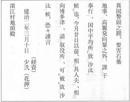
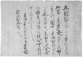
An instruction dated to the third lunar month of 1276 shows one point at which this happened. Shōni Tsunesuke, an official involved in Kyushu's defense, addressed the land steward of Fukae village. He ordered the steward to bring workers to Hakata by the twentieth of that month and receive an assigned worksite. The surviving document thus gives a destination, a deadline and a procedure for putting a contribution to work.[5]
The sequence is important. The steward was not merely instructed to send money or promise support. He had to assemble people, bring them to the port and take responsibility for a specified portion of the undertaking. The document identifies the person answerable for arranging the labor; it does not name the workers he was to bring.
The deadline concerned arrival and assignment, not completion of the entire coastal wall. The instruction also distinguished these workers from men allocated to a projected expedition against Goryeo. Defensive construction operated alongside other military preparations, with different demands competing for personnel. The letter records how one obligation was assigned, not a complete census of everyone engaged in the project.
Land supplied a basis for apportionment. Fukuoka's educational account describes an assessment of one sun of wall for each tan of land: approximately three centimetres of wall for about a thousand square metres of assessed holding. Seinan Gakuin University's explanation gives the same ratio.[6] The small units made it possible to express very different holdings in a common measure of construction liability.
Such a formula did not itself quarry a stone. It connected an existing way of reckoning land to a new task on the coast. The Fukae instruction supplies the next step: an accountable holder was to appear with workers and receive his share of the work. Between an assessment and a finished wall stood the practical business of assembly, travel and construction.
Nor would equal lengths necessarily require identical efforts. A stretch near an accessible source of stone presented different conditions from one needing another material or a different foundation. The formula assigned an obligation in length; the excavated remains show how much variety could exist within that common unit. The problem was to make separately supplied sections join into something useful, without requiring every contributor to build in precisely the same way.
3. Local stone, distant obligations
Imazu makes that combination particularly clear. Its granite is associated with Kōshidake to the west, its basalt with Bishamonyama to the east. The city's account connects the alternating stretches with divisions of responsibility involving Hyūga and Ōsumi, provinces in southern Kyushu, and with further allocations according to holdings. The provincial attribution is an archaeological and documentary interpretation; the differences in material are the physical evidence it seeks to explain.[1]
Responsibility and supply need not have followed the same route. A lord or steward could owe work because of land in one part of Kyushu while obtaining building material near the assigned beach. Provincial participation therefore does not mean that every contributing district transported its own distinctive rock across the island. The nearby sources at Imazu point instead to construction organized through both regional obligations and local resources.
Fukuoka City Museum describes the work as proceeding in separate sections, with stone and clay obtained in their vicinity. Where such sections meet, changes in construction can help identify the divisions. Its account associates this parallel working with the rapid completion of the main undertaking, within roughly half a year.[7]
Parallel construction offers a straightforward explanation for speed: several groups could advance their own portions without waiting for a single building team to reach them. It also created a requirement at every boundary. A contributor's finished stretch had to meet the neighboring work closely enough to function as part of the same obstacle. The visible changes are consequently useful evidence of organization, not simply departures from an ideal uniform façade.
Ikinomatsubara provides a second comparison. Its western work uses rock associated with Nagatare, including granite and pegmatite; the eastern part uses sandstone associated with Odo. The city's description also distinguishes the Higo responsibility at Ikinomatsubara from the Hizen responsibility toward Meinohama. It suggests that the change in stone may correspond to that division.[8]
The correspondence is suggestive precisely because it joins different kinds of information. A document can assign a district without describing each stone. A stone can indicate its source without naming the person who ordered it carried. Together they make a more specific account possible: distant obligations were fulfilled through work at particular beaches, using materials that could be acquired there. The whole line did not have to be materially identical to be administratively connected.
4. What stood behind the stones
Differences extend through the wall, not just along its face. At Imazu, investigators recorded a substantial construction filled with stone and sand, without the clay found in some other sections. At Ikinomatsubara, a stone face was backed by clay. The published cross-sections depict different arrangements rather than one standard wall reproduced around the bay.[9]
This is why a photograph of the seaward masonry gives only part of the engineering story. The material behind it helped form the obstacle, while its base had to occupy a shoreline of dunes and changing ground. At Nishijin, excavation identified clay placed at the base on the sand dune. The support beneath the visible stones belongs to the defensive work as surely as the outer face does.[3]
A university building project revealed something less expected. At Seinan Gakuin, investigators found an earthen bank running behind the stone wall, separated from it by about a metre. In the excavated stretch, this produced a double arrangement rather than a single backed wall. Its military function remains unresolved, but the excavation establishes that the defense at this point occupied more space and contained more components than its stone front alone would suggest.[10]
The contrast with Imazu is already informative. The people implementing a common coastal project did not leave a uniform cross-section. Organization could be shared while construction differed. To understand how the wall was made, the joints, backing and foundations must be read together; none can safely stand for the entire defensive system on its own.
5. A barrier in a moving war
When the invasion returned in 1281, the fleet approaching from Korea was joined in the wider campaign by a separate force sailing from southern China. The stone defenses confronted landing attempts around Hakata, while Japanese fighters also went out in small boats to attack the invading vessels. Fukuoka's historical brochure presents the barrier and these boat actions as connected elements of the defense.[11]
Their relationship makes sense without turning the wall into a weapon that fought by itself. Men behind a barrier could contest access to the shore; men in boats could approach a fleet that remained afloat. These were different ways of operating in the same coastal space. The barrier's contribution was to alter the conditions under which attackers could establish themselves on land, not to destroy their ships at a distance.
Historian Thomas Conlan emphasizes the extent to which the 1281 fighting unfolded around islands and at sea. His work challenges accounts in which Japanese resistance disappears behind the eventual storm. That emphasis is useful here because it puts the wall inside a campaign larger than Hakata's beaches, instead of making it the substitute for a story told entirely through weather.[12]
The storm and the losses at sea still belong to the account. Archaeological research around Takashima, beyond Hakata Bay, has recovered material associated with the invading fleet, including ceramics, metal objects and an official seal. Matsuura's archaeological centre identifies these finds with its investigations of the 1281 disaster.[13] They concern another part of the expedition's experience, not objects recovered from the foot of the Hakata wall.
A fleet's destruction near Takashima cannot by itself measure the effect of a particular defensive section at Imazu. Equally, the existence of the wall does not make the storm inconsequential. The campaign brought together landing attempts, armed resistance, movement between anchorages and severe weather. The wall changed one important part of that sequence: the passage from water to shore in a bay that had already been attacked.
6. After the fleet had gone
The withdrawal of the invasion did not immediately release everyone from coastal obligations. Fukuoka City Museum's document catalogue includes a 1287 directive concerning stakes at the mouths of the Muromi and Tatara rivers. The river entrances required attention alongside the stone-built stretches. The defensive problem continued to be the shape of the coast, not simply the condition of its longest masonry sections.[14]
The same catalogue places fourteenth-century documents in the history of repair, including an instruction issued under Ashikaga Takauji in 1342. The works had therefore remained a concern beyond the Kamakura government's lifetime. A construction completed for an anticipated return could become a continuing obligation under another military authority.
These records change the timescale of the ruins. Between 1274 and 1281, a new line had to be raised quickly. Afterward, responsibility included maintaining or supplementing what had been made. A wall could outlast the immediate emergency while continuing to demand decisions about labor and repair.
Maintenance also complicates the material story. The Ikinomatsubara account identifies a line of basalt stones in front of the principal work as a probable repair.[8] A change in stone can thus have more than one historical explanation. It may mark neighboring contributors, or it may belong to work performed at a later date. The archaeological sequence is needed before a seam can be turned into a boundary between medieval assignments.
7. Finding the coast again
Modern investigation began to make these distinctions recoverable. Work at Imazu in 1913 helped establish the remains, and systematic investigations in the later 1960s and early 1970s examined multiple sections. National protection, begun in 1931, did not make the whole line visible at once. Knowledge accumulated as separate pieces were exposed and compared.[15]
At Nishijin, reclamation moved the shoreline farther north, leaving the defensive site inland. The section found at Seinan Gakuin was subsequently moved approximately twelve metres to the northeast and reconstructed for preservation inside a university building.[10] Its material and recorded plan remain valuable, but the display's position cannot be used as an exact medieval coastline marker.
Discovery has also extended beyond the previously familiar stretches. Excavation at Kyushu University's former Hakozaki campus, beginning in 2016, identified another part of the defenses. The Hakozaki remains received additional national designation in 2020 and 2021.[16] The city's modern geography had concealed part of a system that historical accounts already placed along the bay.
The dispersed remains therefore ask to be understood at two scales. At the larger one, they formed an obstacle against landing around a threatened coast. At the smaller one, every portion had a material source, a construction arrangement and a share of responsibility. A continuous line on a historical map can communicate the first. The changes between granite and basalt, the backing behind the face and the instructions sent to individual stewards recover the second.
Hakata's defensive shore was assembled through those shares. Its significance lies in how they joined: separate obligations became neighboring works, and neighboring works gave armed defenders a different shoreline on which to meet another invasion.
Next topic · HO Guides
Hizen Nagoya Castle: Building a Court for a War Overseas
Palaces, performances and a letter about peace reveal how a temporary headquarters joined domestic rule to an invasion—and received its consequences.
Continue readingSources and NotesView sourcesHide sources
- [1]
Fukuoka City, “元寇防塁(今津)” [Genkō Bōrui: Imazu], cultural-property record 38, full descriptive entry, especially the paragraphs on Kōshidake/Bishamonyama stone and the proposed provincial allocation. The source distinguishes observed material from the explanation of alternating sections. https://bunkazai.city.fukuoka.lg.jp/sp/cultural_properties/detail/38
Return to the reference ↑ - [2]
Kokugakuin University Museum, “Underwater Archaeology Reveals the Mongolian Invasion of Japan, Part I,” 2024 exhibition introduction, opening campaign paragraphs. Used for the Yuan–Goryeo expedition and Korean departure point, not the site's unrelated early-history comparisons or an estimate of troop numbers. https://museum.kokugakuin.ac.jp/en/special_exhibition/detail/2024_mouko_pt1.html
Return to the reference ↑ - [3]
Fukuoka City, “元寇防塁(西新)” [Genkō Bōrui: Nishijin], cultural-property record 36, full entry, paragraphs on the 1274 landing landscape and the excavated base. The city's description explicitly notes gaps in identifying this section's medieval builders and guard arrangements. https://bunkazai.city.fukuoka.lg.jp/sp/cultural_properties/detail/36
Return to the reference ↑ - [4]
Fukuoka City Museum, exhibition leaflet 23, “元寇防塁” [Genkō Bōrui], 1991–1992 exhibition, introductory history; Fukuoka City Board of Education, English archaeological-sites brochure, wall-history page. See both brochure pages and their diagrams. Approximate total length describes the dispersed system, not an unbroken exposed wall. https://museum.city.fukuoka.jp/archives/leaflet/023/index.html ; https://bunkazai.city.fukuoka.lg.jp/publications/pdf/shiseki_en.pdf
Return to the reference ↑ - [5]
Shōni Tsunesuke's instruction to the steward of Fukae village, Kenji 2, third month, tenth day (1276), Fukae documents, reproduced by Fukuoka City Museum in leaflet 23. See the museum's printed transcription and reduced manuscript image; the transcription is the basis of the paraphrase, not a new palaeographic edition. “Before the twentieth” concerns arrival at Hakata with workers and receipt of the assignment. The third month is lunar, not modern March. Main entry: https://museum.city.fukuoka.jp/archives/leaflet/023/index02.html ; transcription: https://museum.city.fukuoka.jp/archives/leaflet/023/images/023_04.JPG ; manuscript image: https://museum.city.fukuoka.jp/archives/leaflet/023/images/023_03.jpg
Return to the reference ↑ - [6]
Fukuoka City Board of Education, English brochure, wall-construction explanation on the second PDF page; Seinan Gakuin University, “元寇防塁” within its facilities account, paragraph on the land-to-wall assessment. These institutional explanations agree on one tan to one sun. The metric equivalents are approximate, and the rule is not used to infer an actual household's burden or a worker headcount. https://bunkazai.city.fukuoka.lg.jp/publications/pdf/shiseki_en.pdf ; https://www.seinan-gu.ac.jp/introduction/facility/facility.html
Return to the reference ↑ - [7]
Fukuoka City Museum, leaflet 23, second page, “築造方法” [Construction methods], complete section. Supports separate responsibility, nearby materials, joins and the approximate half-year building period. The explanation of parallel work is not a reconstruction of a particular crew's daily schedule. https://museum.city.fukuoka.jp/archives/leaflet/023/index02.html
Return to the reference ↑ - [8]
Fukuoka City, “元寇防塁(生の松原)” [Genkō Bōrui: Ikinomatsubara], record 34, full descriptive entry, material/provincial attribution and probable-repair paragraphs. The essay retains the source's uncertainty about correlating stone types with assignment boundaries. It does not adopt a precise identification of a surviving stretch with the wall represented in the Mongol-invasion scroll. https://bunkazai.city.fukuoka.lg.jp/sp/cultural_properties/detail/34
Return to the reference ↑ - [9]
Fukuoka City Board of Education, English brochure, second PDF page, construction cross-sections; the Imazu and Ikinomatsubara descriptions in notes 01 and 08. These are interpretations of excavated sections, not measurements independently made by this author. https://bunkazai.city.fukuoka.lg.jp/publications/pdf/shiseki_en.pdf
Return to the reference ↑ - [10]
Seinan Gakuin University, facilities account, “元寇防塁,” paragraphs describing the Building 1 excavation, separate earthwork and relocation. See the institution's excavation and presentation account; its wider historical introduction is not adopted wholesale. The double arrangement's function is expressly unresolved. https://www.seinan-gu.ac.jp/introduction/facility/facility.html
Return to the reference ↑ - [11]
Fukuoka City Board of Education, English brochure, first PDF page, 1281 campaign account; see also Kokugakuin's exhibition introduction cited in note 02. Used for the two approach forces, coastal defense and boat attacks; no exact fleet or casualty total is asserted. https://bunkazai.city.fukuoka.lg.jp/publications/pdf/shiseki_en.pdf
Return to the reference ↑ - [12]
Thomas D. Conlan, “The Mongol Invasions of Japan,” scholarly digital project, surviving Bowdoin introduction. Only the accessible introductory argument was read: the dynamic scroll viewer was not accessible, and the associated book was not read for this essay. The military emphasis is attributed; it is not represented as proof that no destructive storm occurred. https://learn.bowdoin.edu/mongol-invasions/
Return to the reference ↑ - [13]
Matsuura City, “松浦市立埋蔵文化財センターガイダンス施設,” opening research account and “元寇資料” collection list; Kokugakuin's 2024 exhibition introduction, archaeology paragraphs. Used for the Takashima research context and kinds of recovered material. No personal inspection of objects, exact sinking date, fleet total or numerical archaeological confirmation of casualties is claimed. https://www.city-matsuura.jp/top/soshikikarasagasu/kyoikuiinkai/bunkazaika/5/7/888.html ; https://museum.kokugakuin.ac.jp/en/special_exhibition/detail/2024_mouko_pt1.html
Return to the reference ↑ - [14]
Fukuoka City Museum, leaflet 23, second page, document catalogue and “修理の様子” [Repairs]. Relevant entries are the 1287 directive concerning river-mouth stakes and the 1342 Ashikaga instruction. Those two complete original documents were not independently transcribed. Their existence supports continuing defensive obligations, not uninterrupted maintenance of every section. https://museum.city.fukuoka.jp/archives/leaflet/023/index02.html
Return to the reference ↑ - [15]
Fukuoka City Museum, leaflet 23, first page, modern investigation and designation paragraphs; the city's Imazu account, note 01. The older museum leaflet's assertion that some eastern remains had not been found is historically dated and is not used as a current inventory. https://museum.city.fukuoka.jp/archives/leaflet/023/index.html
Return to the reference ↑ - [16]
Fukuoka City, “史跡元寇防塁(箱崎地区)整備活用事業,” updated 10 September 2026, introductory history under the Hakozaki-project heading. Used for excavations beginning in 2016 and additions to national designation in 2020/2021, not proposed facilities or future access. The page's contemporary civic-development claims are not adopted as medieval history. https://www.city.fukuoka.lg.jp/keizai/ds-suishin/life/genkoborui_hakozaki.html
Return to the reference ↑