Map: GSI Japan The Kioizaka assassination site is an altered piece of central Tokyo where road, slope, park, and memorial preserve different parts of one political killing. On the morning of 14 May 1878, Home Minister Okubo Toshimichi was attacked in his carriage on the road at Shimizudani while traveling to the temporary imperial palace. The stone memorial now in Shimizudani Park was erected nearby ten years later; it is not the murder weapon, carriage, or an exact preserved crime-scene structure. The Place matters because it connects the violence of early Meiji state formation with the later official language used to commemorate one of its most powerful architects.
The Roadside Attack of 14 May 1878
Attraction
Okubo Toshimichi left his residence by carriage on the morning of 14 May 1878 for the government offices at the temporary imperial palace. Six former samurai attacked the carriage on the road at Shimizudani and killed the Home Minister. The event is conventionally called the Kioizaka Incident because the carriage's approach was associated with the slope, but Chiyoda's place history specifies the road in front of Shimizudani. This distinction prevents a picturesque slope name from replacing the documented urban setting. What can be encountered now is the route landscape and nearby commemoration, not a preserved carriage stop or sealed nineteenth-century crime scene.
Current visibility
The road and valley setting remain legible in altered urban form; no assassination structure or carriage survives on site.
Political Violence after the Satsuma Rebellion
Attraction
The attack followed a decade in which the new government abolished domains, dismantled hereditary privileges, suppressed uprisings, and concentrated administrative power. Okubo, as the first Home Minister and a leading state builder, personified those changes for opponents. Chiyoda's official account places the assassination after the government's defeat of the Satsuma Rebellion and links the attackers' hostility to former-samurai grievances. That context explains a target without excusing murder or reducing every critic of the government to an assassin. The site exposes a central contradiction of the early Meiji order: institutions presented as national reconstruction were imposed through coercive decisions that generated losers, armed resistance, and retaliatory violence.
Current visibility
The political conflict is interpreted through the documented event-location relationship; it has no separate surviving physical installation on the road.
The 1888 Memorial Is an Argument about Okubo
Attraction
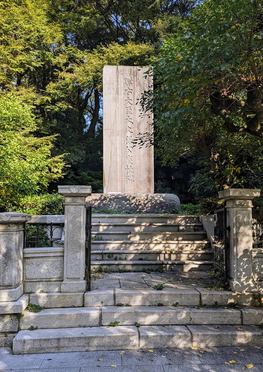
The large stone memorial was erected in May 1888, ten years after the assassination, on Kitashirakawa princely land near the place of attack. Its inscription praises Okubo's service to the state and seeks to carry his achievements to later generations. That language is evidence of official commemoration, not a neutral verdict on his government. The monument postdates the event and shifts attention from the assailants, carriage, and contested reforms toward sacrifice and national service. Chiyoda designated it a cultural property in 1992. Visitors therefore encounter two historical moments at once: the violence of 1878 and a state-centered memory project built in 1888 to stabilize Okubo's public meaning.
Current visibility
The 1888 memorial stands in Shimizudani Park near, rather than as an exact material remnant of, the attack site.
Shimizudani Park and the Altered Valley
Attraction
Shimizudani took its name from springs in the low ground below the former daimyo-estate plateau. After the assassination, the memorial parcel became part of a public park developed by Tokyo City in 1890 and later transferred to Chiyoda City. Hotels, offices, universities, roads, and government districts have since transformed the wider setting. The surviving slope-and-valley relationship helps explain why the event acquired the Kioizaka name, while the park provides space for the later monument. It should not be staged as an unchanged tableau: traffic, planting, grading, and redevelopment have rewritten the scene. Current public access is ordinary park access and remains subject to municipal management rather than a dedicated historic-site schedule.
Current visibility
The public park, monument, road, and topographic relationship are visible, but the nineteenth-century streetscape and estate boundaries have been extensively altered.