Read the article below. Interactive reading tools are available when scripts load.
Quick
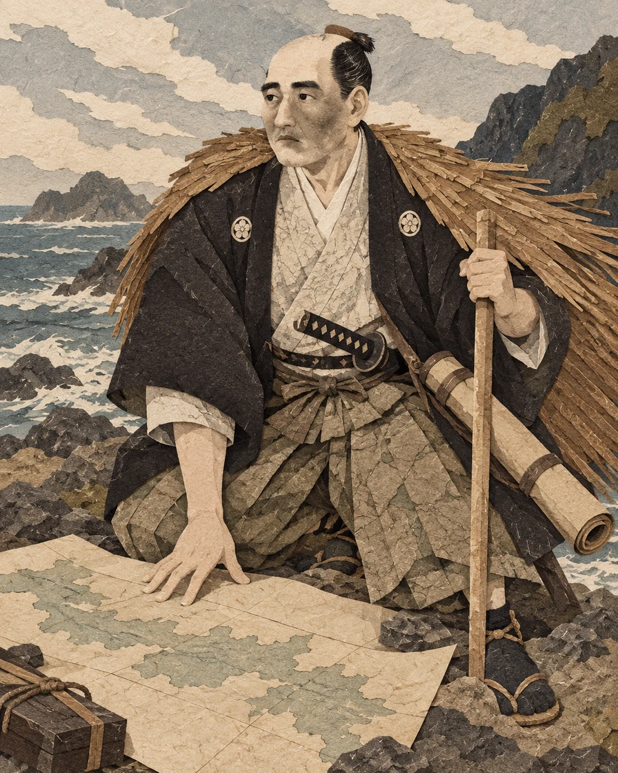
Mamiya Rinzō was born in Hitachi, now Ibaraki, in 1775 or 1780: standard references preserve both years. His family farmed and made hoops for wooden containers. Practical skill in arithmetic helped him enter work connected with the shogunate, Japan’s warrior government. He learned surveying from Murakami Shimanojō, an official geographer, and followed him north in 1799. Measuring land gave a man from a rural household a useful place in government service. His later learning from Inō Tadataka, the national coastal surveyor, added astronomical observations to this preparation. [1][2][3]
In 1800 Rinzō entered shogunal employment in Ezo, principally present-day Hokkaido. At its southern port of Hakodate he met Inō Tadataka and later learned the use of celestial observations to determine latitude, a position’s distance north or south of the equator. His own work ranged across northern coasts, including western Ezo in 1803 and the Kuril island of Etorofu in 1806. Russian attacks in 1807 made the government’s limited knowledge of the north more urgent. Surveying could assist defense and administration as well as improve a map. Rinzō’s later Sakhalin assignments grew from repeated work in this changing frontier; they were not his first encounter with northern geography. [1][2][3]
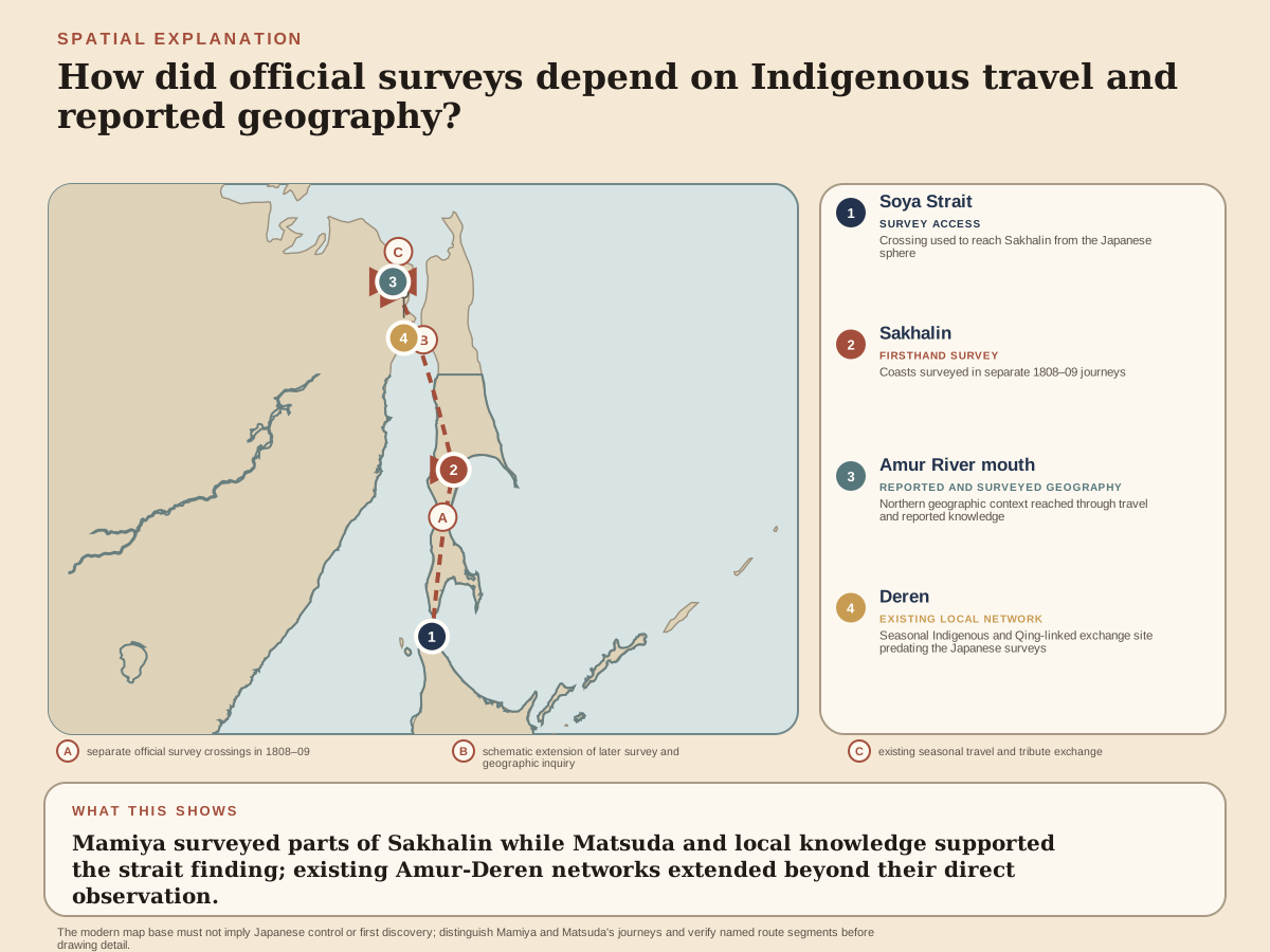
In 1808 the shogunate sent Rinzō and Matsuda Denjūrō to Sakhalin, then called Karafuto. Matsuda worked along the west coast and Rinzō along the east; their information brought them toward the island’s northern geography. Rinzō undertook further travel spanning 1808–1809 and crossed to the mainland with local assistance. These expeditions established for shogunal geographical work that Sakhalin was separated from the continent by water. A familiar modern map conceals the original task: distinguishing a coastline personally followed from a connection still inferred. The sea passage became associated with Rinzō’s name, while Matsuda’s work and the boats and knowledge of local residents made the investigation possible. [1][2][3][11]
Rinzō’s 1809 mainland journey took him to Deren on the lower Amur River, where officials of China’s Qing dynasty received fur tribute and distributed rewards. He traveled with a party led by Kōni of Noteto on Sakhalin, a local headman belonging to the ancestors of today’s Nivkh people. Sasaki Shirō’s study reconstructs eight people in the boat, including Rinzō, a woman and a child. The journey followed an established regional circuit. Seasonal official business also brought traders together; silks and other goods moved through networks linking the mainland, Sakhalin and Ainu communities in Hokkaido farther south. Rinzō’s report records encounters within that active world, whose participants supplied more than anonymous assistance to an explorer. [5][6][7]
After Rinzō’s return, Murakami Teisuke recorded and edited his oral account. Teisuke was connected to Rinzō’s teacher Murakami Shimanojō and served in the northern magistrate’s office. Tōdatsu Chihō Kikō described the mainland journey, while Hokui Bunkai Yowa recorded Sakhalin’s geography, residents, livelihoods, trade and customs with illustrations. The records were compiled around 1810 and presented to the shogunate in 1811, together with map material. “Rinzō’s writings” thus include work produced through an observer and an editor. The resulting descriptions preserve valuable encounters, but their organization and labels also belong to the officials who turned them into a government archive. [3][4][5]
Rinzō continued surveying Ezo after the Sakhalin and mainland journeys. From 1812 his work covered coastal areas beyond Inō Tadataka’s earlier route. Measurements by Rinzō and other contributors entered the geographical body from which the national map was completed in 1821, after Inō’s death. In 1822 Rinzō returned to Edo, now Tokyo, and continued as a public-works official. A 1824 assignment concerned coastal defense in the Bōsō peninsula, now Chiba. The famous northern crossing was one phase in a longer working life: gathering reliable positions and coastlines could serve maps, public administration and inspection of places exposed to foreign ships. [1][2][11]
In 1828 a parcel from Philipp Franz von Siebold, the German physician working with the Dutch trading establishment in Nagasaki, reached Rinzō through Takahashi Kageyasu. Kageyasu was a shogunal astronomer and map editor. Rinzō submitted the parcel to the authorities, helping direct official suspicion toward Kageyasu’s dealings with Siebold. Their exchange included detailed Japanese maps prohibited from export. Investigation led to arrests; Kageyasu died ill in custody, and Siebold was expelled in 1829. Rinzō’s role acquired the reputation of an informer. The documented submission is clearer than his private intention. It formed part of a developing investigation, not a complete explanation of every discovery and punishment in the case. [9][10][8][1]
Rinzō’s later assignments included inquiries into foreign-ship incidents and illicit trade. He also had contacts with Mito officials concerned with coastal defense. He died in 1844 while still recorded as a public-works official under the finance magistrate, an official overseeing government revenue. Meanwhile, Siebold’s European publication Nippon circulated northern geography and associated the sea passage between Sakhalin and the mainland with Rinzō’s name. Manuscripts and maps had another later history through preservation: the National Archives corpus received important-cultural-property designation in 1991. His legacy includes an accomplished surveyor, a controversial official role and records through which later readers can encounter both his journeys and the societies that made them possible. [1][2][3][4]
Classic
Historical disagreement · Two surviving birth dates
Rinzō came from Kamihirayanagi in Hitachi, a village in present-day Tsukubamirai, Ibaraki. His household combined farming with making hoops for wooden containers. Biographies differ between 1775 and 1780 for his birth; the National Archives account uses the latter, while another signed reference uses the former.
The household livelihood supplies firmer context than an exact age at each early turning point. He began outside a hereditary warrior office but developed a skill that government employers needed. [1][2][3]
Murakami Shimanojō, a geographer working for the shogunate, Japan’s warrior government, taught Rinzō surveying. The techniques included measuring angles and distances to determine positions on land. This was an applied education: a usable observation had to connect one point to another, rather than remain a statement that a place lay somewhere north. Reference accounts also associate recognition of Rinzō’s arithmetic with public works. [1][2]
Following Murakami to Ezo in 1799 brought Rinzō into a region where officials needed geographical information. Ezo here means principally present-day Hokkaido and the northern territories associated with its administration. Government work offered travel, instruction and practical assignments beyond his village. It also directed the use of what he learned. His career began through particular teachers and employers, and would continue through a mixture of observation, written reports and official investigation. [1][2][3]
Rinzō’s 1800 employment in Ezo and meeting with the coastal surveyor Inō Tadataka at Hakodate, its southern port, were separate from the previous year’s first journey. Inō’s instruction later included celestial observations for latitude, position north or south of the equator. Land measurements connect distances and directions along a route; observations of the heavens help place that route within a larger geographical frame. Combining them could strengthen a coastal outline beyond a sequence of local distances. The formation joined Murakami’s practical surveying to methods associated with Inō’s national work. [1][2][3]
Rinzō surveyed western Ezo in 1803 and worked on the Kuril island of Etorofu in 1806. These were journeys through inhabited lands and maritime settings used by Indigenous communities, traders and officials. They expanded his knowledge through successive routes rather than one sudden discovery. The early shogunal survey system was itself cumulative. A later compiler might join observations from several people whose expeditions covered different stretches of coast. Rinzō would become one of the contributors to that larger body of geographical work. [1][2][11]
Russian activity gave northern geography immediate official importance. Attacks on Japanese positions in 1807 exposed weaknesses of defense and administration; Rinzō was questioned in connection with events on Etorofu. Reference accounts say that he was not punished. His ensuing Sakhalin assignment belonged to a government seeking more reliable information about coastlines and approaches. The pressure helps explain why geographical work received support. It also places his measurements within an unequal expansion of official knowledge over lands whose residents already knew and traveled them. [2][3][11][7]
Sakhalin’s relationship to the mainland remained unresolved in earlier Japanese official maps. A 1801 investigation had measured parts of its southern coasts, while information about the north relied on residents’ reports. Some resulting maps retained both island and peninsula possibilities. Rinzō and his fellow shogunal official Matsuda Denjūrō were entering a sequence of investigations with an identifiable gap: a southern outline did not establish how the island ended in the north. The 1808 commission directed two officials toward that missing connection. [11][3]
Historical disagreement · When was the island’s separation confirmed?
Matsuda followed the western coast, while Rinzō worked along the eastern side. Their routes supplied different portions of the outline. Rinzō then undertook a further investigation spanning 1808–1809, reaching the northern area and crossing toward the mainland. References compress the moment of island confirmation differently between the expeditions; the sequence is clearer than a single triumphal date. The 1808 work and 1809 continuation together changed what officials could responsibly represent on a map. [1][2][3][11]
The National Archives exhibition and the Hokkaido University library’s published history of northern maps place confirmation in the 1808 investigation. Funatsu Isao’s signed encyclopedia biography connects it with the 1809 crossing.
These compressed accounts support the broader sequence, but do not settle an exact first-confirmation date. [3][11][1]
The geographical conclusion depended on travel through waterways that residents already navigated. Rinzō crossed with local participants and continued into the lower Amur region. Their boats and journeys supplied a way to inspect a passage and places beyond it. For officials in Edo, the information established an island’s separation from the continent. For those providing passage, these waters already connected homes, trade and tribute destinations. The investigation added a new official account to an existing geography of movement. [1][2][5][6]
Kōni, a headman at Noteto on Sakhalin’s western coast, had received Matsuda in 1808 and guided Rinzō on the 1809 mainland journey. Sasaki Shirō identifies him as belonging to the predecessors of today’s Nivkh people. His position combined local influence with a village-head title recognized under arrangements of China’s Qing dynasty. Rinzō traveled through a host’s connections and itinerary, within a region where residents exercised their own authority. [5][6]
In a close reading of Rinzō’s recorded account, Sasaki reconstructs a boat carrying eight people. Rinzō was among them, alongside men from Noteto and another participant accompanied by a woman and child, apparently his family. Kōni led the party. The study also notes that another participant’s inherited Qing rank could be formally higher than Kōni’s. Local leadership on a journey did not simply follow the order of official titles. The boat was a social group undertaking its own business, with a Japanese observer traveling inside it. [5]
At Deren on the lower Amur River, Qing officials operated a seasonal branch post for receiving fur tribute and granting rewards. This extended administration through local leaders and recurring visits rather than a permanent official stationed in every village. The summer gathering also created a market, bringing residents and traders together while transport on the river was available. Rinzō observed the place during his 1809 journey. His account therefore concerned a political and commercial institution, rather than only a point reached across the sea. [5][6][2][3]
Historical disagreement · Were the northern communities isolated?
Chinese silk robes, glass beads and coins circulated through networks linking the lower Amur, Sakhalin and Hokkaido. Different Indigenous traders connected or distributed goods across these routes; Nivkh predecessors and the groups called Santan in Japanese records should not all be treated as one people. Sasaki’s research uses such trade to challenge older pictures of isolated communities living only from local foraging.
Rinzō’s observations matter partly because they preserve evidence of this wider world. The residents who enabled his journey were also participants in the exchanges he reported. [5][7]
Murakami Teisuke recorded and edited Rinzō’s oral account after the northern journey. He was a pupil and adopted son of Murakami Shimanojō and served in the Matsumae magistrate’s office. Those connections gave the compilation an administrative and personal setting. The National Archives identifies an oral author and a recording editor. Attributing the corpus to Rinzō recognizes the traveler whose observations informed it, while Teisuke’s work explains how those observations acquired a durable textual form. [3][4]
Tōdatsu Chihō Kikō followed the mainland journey. Hokui Bunkai Yowa, in ten folded books, treated Sakhalin’s geography, residents, livelihoods, trade and customs, accompanied by illustrations. Map material represented another part of the investigation. The forms could preserve a route, describe activities and make spatial relations visible. Composition around 1810 and presentation in 1811 are distinct stages; the latter placed the work among records received by the shogunate. The documents brought distant travel into the institutions that had commissioned it. [3][4]
Evidence boundary · Official categories and northern societies
The corpus is unusually valuable for its detail on people and practices in Sakhalin and the lower Amur region. Modern research can compare its descriptions with Qing records and later ethnography to reconstruct trade and local offices.
That value does not make a Japanese official’s classifications identical to residents’ own account of their society. Sasaki’s work distinguishes the populations grouped under older labels and asks how an observer’s viewpoint shaped later scholarship. Reading the record through named participants and material exchanges helps recover a world larger than the explorer’s achievement. [5][6][3]
From 1812 Rinzō surveyed coastal areas in Ezo that Inō Tadataka had not personally measured. The western coastline was an important part of this contribution. Inō’s 1800 expedition had covered portions of the south and east; its route did not supply the whole island’s outline. Joining these observations required more than preserving a famous leader’s travel record. Rinzō’s work helped fill a geographical gap in the material available to later mapmakers. [1][11]
The national coastal map was presented to the shogunate in 1821. Inō had died in 1818, leaving living collaborators and the astronomy office to finish the work. Measurements made by Rinzō and others contributed to the northern geography associated with the completed map. The conventional name “Inō map” identifies the principal survey project, but does not assign every measured coastline to one traveler. Rinzō’s contribution belongs within that shared process of fieldwork and compilation. [1][11][10]
Returning to Edo in 1822, Rinzō worked as a public-works official. In 1824 he assisted with coastal-defense work on the Bōsō peninsula, an area of present-day Chiba facing the Pacific and the approach to Edo Bay. The later career brought survey experience into inspection and official reporting nearer the government’s center. Northern maps, defense needs and public-works employment connected through the service of people able to observe places and submit usable information. Rinzō’s next prominent involvement would concern the circulation of such knowledge beyond official permission. [1][2][3]
Historical interpretation · The parcel and the delayed departure
The chronology assembled by Ishiyama Yoshikazu and Miyazaki Katsunori records a 1828 parcel sent to Rinzō by Philipp Franz von Siebold, the German physician at the Dutch trading establishment in Nagasaki, through Takahashi Kageyasu, a shogunal astronomer and map editor. Kageyasu delivered it, and Rinzō submitted it to the authorities according to official rules. Investigation then concentrated on Kageyasu. This sequence preceded the storm that delayed the Dutch ship’s departure from Nagasaki.
It complicates the familiar compressed story in which a wreck suddenly exposes forbidden maps and alone begins the affair. Different pieces of information reached officials at different stages. [9]
Siebold sought detailed information about Japan, while Kageyasu obtained foreign geographical works. Kageyasu’s position in the shogunal astronomy and map offices gave him access to material useful for that exchange. Detailed Japanese maps were restricted from foreign export. Officially, the dealings could therefore be investigated as prohibited circulation even when participants pursued learned aims. Rinzō’s submission helped disclose a contact within this setting. The same world of maps and reports connected his survey career to a case over who could possess and transmit geographical knowledge. [9][10][8][1]
Historical disagreement · What did Rinzō’s report establish in the Siebold affair?
Later biographies often call Rinzō the case’s informer. A library review of the literature distinguishes his submission from a deliberate denunciation of the entire map exchange, while noting his lasting reputation.
The recorded act helped bring official attention to Kageyasu; it does not by itself establish jealousy, a wish to punish a former collaborator or complete knowledge of what investigators would find. These private explanations would add certainty beyond the surviving sequence. The consequential act can be described without choosing a motive that the inspected material does not demonstrate. [8][9]
Kageyasu was arrested and died ill in custody. Siebold was expelled in 1829, and numerous Japanese participants were punished. These consequences distinguish knowledge exchange from a harmless correspondence between scholars. Rinzō’s work had helped turn northern experience into information held by the state; now a submission helped officials investigate the movement of that information beyond permission. The case leaves a difficult conjunction in his career: geographical inquiry and official surveillance operated through overlapping relationships, with severe costs for other participants. [10][9][8][1]
Rinzō’s later work included investigation of foreign-ship events and illicit trade. Reference accounts describe covert assignments as part of this service. From 1834 he also maintained contact with figures in Mito, including Fujita Tōko, involved in coastal-defense concerns. These duties extended the information-gathering side of the career beyond surveying. [1][2][3]
Rinzō died in 1844, on the twenty-sixth day of the second month in the Japanese traditional calendar. That is not automatically 26 February. The National Archives records him at death as a public-works official supervised by the finance magistrate, who oversaw government revenue, with a stipend of fifty rice bales and allowances for three persons. The entry anchors the ending in the government’s offices and remuneration. His life had joined a rural origin to decades of specialized service, through repeated observation, northern travel, compilation and official inquiry. [1][3]
Siebold’s Nippon disseminated northern geographical information in Europe and associated the passage between Sakhalin and the mainland with Rinzō’s name. A man expelled over restricted information became an important agent of its wider circulation. The northern records also survived as manuscripts and maps in Japanese custody. In 1991 the grouped National Archives corpus received important-cultural-property designation. European publication and archival preservation transmitted different forms of the work; neither made Rinzō the sole author of the geography it contained. [1][2][3][4]
The corpus preserves more than a line on a map. Modern research can use its descriptions of village leaders, boat parties, trade and Qing official business to recover relationships obscured by a single explorer’s fame. Kōni’s party supplies a concrete example: residents followed a familiar circuit while carrying a Japanese investigator into it. Rinzō’s achievement was consequential for official geography, and its surviving record remains valuable for studying other people’s lives. Keeping these contributions visible gives the investigation a fuller historical scale. [5][6][3][7]