HO Guides
Tsuruga Castle: A Fortress Rebuilt for Visitors
A park planner, a reconstructed keep, and the foundations of a storehouse reveal different answers to what a city should do with its former fortress.
Quick · About 2 min
The story in five points
A short route through the argument. Follow a point into Classic for its context and sources.
Defeat and demolition were separate
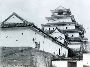
Tsuruga Castle endured a month-long siege in 1868, but its keep survived until dismantling in 1874. Pre-demolition photographs therefore record damaged buildings and connections that would otherwise be missing from later reconstruction evidence.
Read in contextThe site became usable as a park
Land preservation preceded a replacement tower. Honda Seiroku's 1917 proposal treated ramparts as possible promenades and recreation grounds, showing that public access needed designed routes and safety measures rather than following automatically from military departure.
Read in contextThe new keep had a different job
The concrete tower completed in 1965 restored a landmark and housed a history museum. Its interior interpreted the former domain; it did not resume the original building's functions or recreate the whole palace-and-defense establishment.
Read in contextArchaeology recovered working relationships
Excavation for Hoshii turret and the South Gallery suggested passageways and storage rooms, with arrowheads consistent with written weapon-storage references. Foundations, finds and photographs combined to explain circulation and supply more precisely than a skyline could.
Read in contextDifferent recoveries coexist today
Timber reconstruction demonstrates architecture while the keep displays history. Returned Rinkaku and renewed red roof tiles represent other interventions. The site combines preserved ground, repaired fabric and modern buildings created for later visitors.
Read in context
Opening
In 1917, the forestry professor Honda Seiroku proposed making the top of a castle wall into a promenade. Steps and protective fencing would help people use a structure originally intended to obstruct their approach. His scheme for Wakamatsu Park combined historical remains with recreation. Rebuilding the vanished keep was not its organizing purpose.[1]
The plan belongs to Tsuruga Castle, also called Wakamatsu Castle, in the Aizu basin of northeastern Japan. The tower familiar today would not rise until 1965. Between the destruction of the old buildings and the creation of the new ones, the ground had to acquire purposes other than defending and governing a domain.
That interval is easily lost when the story moves straight from the siege of 1868 to a photograph of the restored skyline. Yet the park, the museum inside the keep, and the wooden structures beside it are different answers to the same practical question: what should people be able to do here once the castle's former government has gone? Following those answers brings the modern building into the history, rather than leaving it outside as a substitute for something older.
1. The Tower Had Neighbors
The stronghold developed through successive building campaigns. Gamō Ujisato enlarged the castle in the 1590s, when the surrounding town acquired the name Wakamatsu. In 1639, Katō Akinari's works gave the keep its five-tiered form and extended the defenses to the north and west. The building later remembered through the siege was already the product of alteration, rather than the first tower erected on the site.[2]
Its setting was a productive basin connected by routes through the surrounding mountains. The castle occupied a position near the southeastern side of the town, not an isolated summit detached from settlement. It belonged to the administration of a territory as well as to the possibility of a battle. The lords needed access to people and resources that could not all be kept within the walls.[3]
Hoshina Masayuki entered Aizu in 1643. His descendants, later bearing the Matsudaira name, governed from the castle through the remainder of the Tokugawa period. A domain was a territorial government under a lord, with its own retainers and administration, within the larger order headed by the shogun. The final Aizu lord associated with the siege, Matsudaira Katamori, had also served the shogunate in Kyoto.[4]
The visible keep was only one part of this establishment. The inner compound contained the palace, while gates, connecting galleries, and corner turrets organized its edge. The Hoshii turret took its name from dried cooked rice kept as provisions; the adjoining South Gallery served storage and defense. Food, weapons, circulation, and protection occupied neighboring spaces.[5]
This arrangement matters to what was eventually rebuilt. Restoring a tower could give the town a recognizable landmark without restoring the relationships among all those buildings. A stronghold in use needed supplies to remain available and people to move between positions. A skyline, however accurate its outline, could not show the whole arrangement. The lower buildings would eventually become central to explaining how the castle had worked.
2. Defeat Did Not Immediately Remove the Building
In 1868, the conflict between the new imperial government and forces associated with the former shogunate reached Aizu. Tsuruga Castle endured roughly a month of siege before surrender. Its occupants lost the stronghold, but the keep did not collapse or disappear at that moment. The surviving buildings were dismantled in 1874.[2][4]
That separation between military defeat and physical removal left time for photography. One pre-demolition view shows the tower rising behind a long, low defensive building. Its walls are damaged, but the rooflines still form an intelligible structure. In the foreground, the gallery and its stone base take up much of the picture. The image preserves a castle with connections, not only an isolated tower.[6]
The photograph also preserves a condition that the present building does not attempt to reproduce. Damage belonged to the castle's life after the siege. A reconstruction of its earlier architectural appearance would necessarily look different from a reconstruction of that damaged state. Before making a new building, someone would have to choose what point in its history the new work was meant to represent.
After demolition, preservation initially concerned the land rather than a replacement keep. A later account maintained by Jūkoku-ji, the temple where the former Aizu retainer and banker Endō Keishi is buried, records his purchase of the castle ground in 1890 and its presentation to the Matsudaira family. The property subsequently passed into municipal ownership.[7]
Acquiring the ground and rebuilding on it were separate undertakings. The first could keep a recognizable site together without supplying the money, design, or agreement needed for the second. A wall and an empty platform could remain available for future purposes while nobody yet knew which buildings would return. Tsuruga's public history began with that more modest form of continuity: the location survived the removal of the institution and much of its architecture.
3. Making a Fortification Walkable
Honda's 1917 park proposal approached the surviving ground as both a historical place and a setting for ordinary recreation. Architectural historian Wangwoo Suh describes a scheme that included gardens, planting, recreational grounds, and adaptations to the ramparts. Honda did not propose rebuilding every lost gate and turret. His attention extended to steps, routes, and safety at the edges of the old defenses.[1]
A defensive wall and a promenade make different demands on their users. The first gains part of its value from making passage difficult. The second must let someone walk along it without turning the height into an uncontrolled hazard. Adding a stair or a fence changes the encounter with the stonework even when the stonework itself remains. Public access therefore had a design history; it was not what automatically happened when the soldiers left.
There was a tension within the proposal too. Honda sought to retain important historical features, but he was prepared to alter other parts of the ground for the park's purposes. His scheme is evidence of a choice being worked out, not proof that every proposed garden or recreational facility was built. It shows a period in which conserving a castle site did not necessarily mean returning it to one complete military appearance.[1]
The distinction helps explain the space around the keep today. An open area can be convenient for a gathering, a view, or a walk precisely because the rooms that once divided it no longer stand. Rebuilding every partition would recover one sort of information while changing the public space that had developed in its absence. Preservation could consequently require decisions about what to leave open as well as what to put back.
National historic-site designation followed in 1934.[8] The ground was becoming an object of protection in its own right, before it regained a tower. Its value no longer depended solely on what a lord could do from it. The surviving walls, moats, and building sites provided a framework within which a different public use could be organized.
4. A Keep with a New Job
The return of the keep was not simply the execution of a plan everyone had always shared. The Broadcast Library's catalogue account of a 2002 Fukushima Central Television documentary records opposition in the city council over the cost, alongside fundraising associated with the mayor. This was a proposal competing for resources, even among people living in the town that would acquire the rebuilt landmark.[9]
The present tower was completed in September 1965. Its construction used concrete, and its interior became a local-history museum. The city later explicitly distinguished this building from the timber reconstruction undertaken beside it.[8][10]
Inside the museum, the former governing household became a subject of display. The keep's outline helped identify that subject before a visitor crossed the threshold; the objects and explanations supplied a history that the outline alone could not give. The interior's new work was interpretation, rather than service to the domain.
The result joined two different forms of recovery. From outside, the tower restored a vertical focus to the castle site. Inside, it offered a place in which the past could be arranged for inspection. Its floors did not return to their old work simply because the roofline resembled the vanished building. The reconstruction created an institution for visitors, using the castle's recognizable form as its address.
Nor did that project complete the site. The present castle precinct includes surviving ground, repaired masonry, returned structures, and later reconstructions. The Rinkaku tea room, for example, had been protected away from the castle and was brought back in 1990. Its return was a transfer of a preserved building, a different operation from making the concrete keep.[11]
By the late twentieth century, the question was becoming more specific than whether the city should have a castle again. Which parts of the former arrangement could be recovered, by what means, and what would they help a reader of the place understand?
5. The Floor Plan under the Grass
The next major reconstruction concentrated on Hoshii and the South Gallery. These buildings connected the keep's vicinity to the defended edge of the inner compound. Their importance lay in a working relationship rather than in rivaling the tower's height.
Excavation in 1996 supplied information that distant photographs could not. Recesses cut into stones indicated where timber had rested. Foundation positions suggested a corridor beside small rooms in the gallery; arrowheads found in the rooms were consistent with documentary references to weapon storage.[12]
The finds changed the questions a new building could answer. A photograph might establish where an exterior wall stood. A foundation could help place the line of posts behind it. Together, those lines began to separate movement from storage: a route along which people could pass and rooms in which materials could be kept. The gallery became understandable as an arrangement of activities, not merely a picturesque stretch of white wall.
An arrowhead on its own would not identify an entire room's use. Its value increased because its location could be considered alongside the foundations and the written identification. The sources supplied different pieces of the same problem. The excavation located the find; the plan explained the room; the record offered a use against which the material could be checked.
This sort of information matters particularly at Tsuruga, where the famous tower can make the surrounding buildings seem incidental. Provisions and weapons were useful because they could be kept within reach of the people expected to use them. Connecting galleries helped organize that reach. Reconstructing one corner of the compound could therefore explain something that a much taller building had left difficult to imagine.
There was also a new practical obligation. The restored structures would contain visitors, while their foundations occupied protected archaeological ground. The builders placed the new supporting arrangement above protected remains, accommodating present safety requirements without simply loading the new work onto every historic trace.[13]
The resulting building has two different relationships with what lies below it. The archaeology helped determine its form; conservation requirements helped determine how it would stand. Rebuilding and preservation could cooperate only after those jobs had been separated.
6. A Photograph Changes Its Date
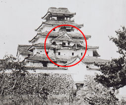
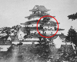
Research for the reconstruction also changed the history of a photograph. For years, pre-demolition views of the castle had been associated with the photographer Koyama Yasaburō and an 1872 journey through the region. During the project, another view surfaced in Japan. Comparing the two revealed a difference in the surviving plaster on a projecting part of the keep. The city's published account concluded that they represented different dates, and reconsidered which photograph could be assigned to Koyama.[14]
The comparison is visible in the paired images reproduced with that account. One shows more of the white facing intact; in the other, more of the material beneath it is exposed. The photographs do not merely offer alternative attractive angles. They record a building undergoing deterioration between separate moments of observation.[14]
This posed a useful difficulty for the reconstruction. A picture can provide very precise information about a roof or wall while still raising questions about when that information was recorded. The builders needed to recover a particular architectural state, not reproduce every difference among the available images. Clearer photographs helped them choose the late-Edo form as the reference for Hoshii and the gallery.[15]
The work was therefore not a simple enlargement of an old picture. A photograph had to be placed in a sequence; its visible details had to be joined to a footprint; the footprint had to support a buildable arrangement. At each stage the question grew more concrete. What looked like a single lost building became a set of decisions about dimensions, materials, and the point in time to be represented.
Those decisions also produced new records. When damaged stones were replaced during the associated repairs, the replacements were marked on their backs with the year of the work. The marks would not improve the finished view. Their purpose was to keep the new material identifiable within a wall intended to look continuous.[13]
A person encountering the castle through its reconstruction could thus be seeing the result of research that also revised what was known about the original. The project did not end with a picture made solid. It left a more detailed account of how the picture, the ground, and the new construction were related.
7. Two Ways to Put History inside a Building
Hoshii and the South Gallery were completed in December 2000 and opened to the public in April 2001. In explaining their intended use, the city made a distinction: the keep housed historical displays, while the timber buildings could themselves demonstrate construction and defensive arrangements. The surrounding museum and the reconstructed architecture were meant to explain different aspects of the same place.[8][10]
That division remains useful even as exhibitions change. A museum can bring together objects from different locations and periods. A reconstructed room asks how a particular space was organized. One can explain a lord's career or an episode in the war; the other can show how a passage relates to a store or how an enclosed edge overlooks the moat. Neither needs to do all the other's work.
The keep acquired another visible change in 2011, when its roof was covered with red tiles intended to recover its late-shogunate appearance. Local interpretation connects the older use of glazed red tiles with the demands of Aizu's cold climate. The new roof brought the twentieth-century building closer to one aspect of the earlier exterior without turning its concrete structure into a surviving Edo-period keep.[16]
The castle now brings several kinds of public use into proximity. Walking through the grounds, entering a museum, and studying a reconstructed timber space are different activities. Their coexistence was made possible by choices extending from land preservation and park design to excavation and building work.
Honda's proposed promenade belongs within that history as much as the returned roofline. Both addressed a place from which the old governing household had departed. The city did not restore the domain by restoring parts of its fortress. It created ways for later people to use the ground and investigate the institution that had once occupied it. Tsuruga's reconstruction is most revealing at that point: where a building made to sustain a government became a place in which the government, the battle, and the buildings themselves could be understood.
Next topic · HO Guides
Mount Iimori: The Making of the Byakkotai Story
A row of nineteen graves became the center of a memorial landscape enlarged by other deaths, school ceremonies, printed lessons, and gifts from abroad.
Continue readingSources and NotesView sourcesHide sources
- [1]
Wangwoo Suh (徐旺佑), 「近世城郭の文化財保護と保存・活用の変遷に関する考察—歴史的記念物の保存・活用の変遷に関する研究 その1」, 日本建築学会計画系論文集 74, no. 643 (September 2009), pp. 2133–2138, especially printed p. 2136, discussion of Honda Seiroku's 『若松公園設計方針』 (1917). https://www.jstage.jst.go.jp/article/aija/74/643/74_643_2133/_pdf . The relevant page was read visually because the extracted Japanese was garbled. The original 1917 plan was not independently inspected. The essay describes proposals, not a verified inventory of completed park works; it does not attribute all present paths or planting to Honda.
Return to the reference ↑ - [2]
Aizuwakamatsu City, 「鶴ヶ城天守閣再建60周年」, historical chronology, entries for the Gamō rebuilding, 1639, 1868, 1874, and 1965. https://www.city.aizuwakamatsu.fukushima.jp/docs/2025063000017/ . The chronology, not the introductory paragraph's inconsistent era/year parenthesis, supplies the 1874 demolition date. The article does not equate a surviving tower with an undefeated government or assign a single unverified motive to demolition.
Return to the reference ↑ - [3]
Aizuwakamatsu Tourism Bureau / Tsuruga Castle, 「鶴ヶ城のご案内」, historical overview under 「鶴ヶ城天守閣」, passages on the Aizu basin, routes, and the castle's position. https://www.tsurugajo.com/tsurugajo/tensyukaku/ . Used for geographical and institutional context; promotional superlatives are not adopted. No historical traffic volume or measured defensive performance is inferred from the location.
Return to the reference ↑ - [4]
Aizuwakamatsu Tourism Bureau, 『鶴ヶ城天守閣』 visitor leaflet, second PDF page, historical chronology and castle overview. https://www.aizukanko.com/image/resource/Document/document/3 . Used for Hoshina's 1643 entry, the subsequent ruling house, Katamori's Kyoto appointment, and the month-long 1868 siege. The account supplies context, not a comprehensive explanation of the Boshin War. Historical Japanese calendar dates are not silently converted into Gregorian days.
Return to the reference ↑ - [5]
Aizuwakamatsu City, 「甦る鶴ヶ城—干飯櫓の復元」, installment 17, 「干飯櫓・南走長屋の役割について」, originally 市政だより, 1 September 2000; also installment 23, 1 April 2001, on the compound and connecting galleries. https://www.city.aizuwakamatsu.fukushima.jp/docs/2018071100053/ . The relevant installments were read as the municipality's reconstruction research, not as independently collated editions of 『家世実紀』. The essay does not infer an exact stock level, ration, or wartime supply transaction.
Return to the reference ↑ - [6]
Pre-demolition photograph reproduced with installment 3 of the municipal series in note 5, identified there as a view in the Achille Bertarelli collection, Milan. Image: https://www.city.aizuwakamatsu.fukushima.jp/docs/2018071100053/file_contents/fukugen03.jpg . The essay describes the visible tower, lower building, masonry, and damage, not a measured survey. The series' later installment 22 revises the earlier photographer/date assumption; consequently this image is not confidently assigned here to Koyama or to a particular day in 1872.
Return to the reference ↑ - [7]
Jūkoku-ji, 「お寺の様子」, 「遠藤敬止の墓」, subsection 「鶴ヶ城趾保存の恩人」. https://jukokuji.jp/about . This custodial biographical account records the 1890 purchase and presentation of the ground and its later transfer to the city. The essay uses “Matsudaira family” rather than adjudicating differing summaries of the individual recipient. No deed was independently inspected. Endō's attributed speech, inconsistent birth/age details, and the page's evaluative political language are not reproduced.
Return to the reference ↑ - [8]
Aizuwakamatsu City, municipal historical chronology, entries for 28 December 1934, 17 September 1965, 5 December 2000, and 1 April 2001. https://www.city.aizuwakamatsu.fukushima.jp/docs/2009020200023/ . Completion in 2000 and public opening in 2001 are separately recorded events, not an invented reconciliation of incompatible dates. The designation applies to the historic site; it does not authenticate the modern keep as original fabric.
Return to the reference ↑ - [9]
Broadcast Programming Center / Broadcast Library, programme 011744, 『ふくしまの素顔 よみがえれ鶴ヶ城—天守閣再建に奔走した人々—』, Fukushima Central Television, broadcast 25 August 2002, 「概要」. https://www.bpcj.or.jp/program/detail/011744/ . Only the catalogue's substantive synopsis was read, not the 29-minute film or its interviews. It supports the narrow statements about financial objections and fundraising, not a reconstructed council debate, exact financing breakdown, or claim of unanimous public support. Its phrase suggesting an unchanged replica is not adopted.
Return to the reference ↑ - [10]
Aizuwakamatsu City, series in note 5, installment 16, 「干飯櫓・南走り長屋の利活用について」, 市政だより, 1 August 2000. It explicitly distinguishes the concrete keep's museum function from the intended interpretation of the timber buildings themselves. Statements about proposed displays remain proposals; the essay does not promise that every 2000 exhibition idea is currently installed.
Return to the reference ↑ - [11]
Aizuwakamatsu Tourism Bureau, castle leaflet in note 4, 「茶室 麟閣」 and the 1990 timeline entry; compared with the current castle overview in note 3. The preservation away from the castle and the 1990 return are used. The traditional attribution to Sen Shōan is not needed to establish the modern transfer and is not presented here as independently authenticated construction history.
Return to the reference ↑ - [12]
Aizuwakamatsu City, series in note 5, installment 2, 「発掘調査」, 市政だより, 1 May 1999. Read in full, including the 1996 campaign, cut seats for timbers, the inferred corridor/rooms, and arrowhead finds. These are the municipal excavators' published identifications, not a new analysis of field records. “Suggested” and “consistent with” preserve the inferential status of room use and arrangement.
Return to the reference ↑ - [13]
Aizuwakamatsu City, series in note 5, installment 8, 「櫓の木構造 その1」, 市政だより, 1 December 1999, paragraph on protected remains, supporting timbers, and visitor safety; installment 4, 「石垣の積み替え」, 1 August 1999, paragraph on replacement stones marked 「平成9年度取替」. The marks were written on the backs, not carved as public inscriptions. No structural calculation, undocumented reinforcement detail, or claim that all stones were replaced is supplied.
Return to the reference ↑ - [14]
Aizuwakamatsu City, series in note 5, installment 22, 「鶴ヶ城の古写真」, 市政だより, 1 March 2001. Full installment and both accompanying photographs: https://www.city.aizuwakamatsu.fukushima.jp/docs/2018071100053/file_contents/fukugen22-1.jpg and https://www.city.aizuwakamatsu.fukushima.jp/docs/2018071100053/file_contents/fukugen22-2.jpg . The later installment expressly revises the earlier blanket association with Koyama's 1872 visit; it leaves the other view's date and maker unresolved. This is a documented revision in the project account, not a claimed independent authentication of either photographic print.
Return to the reference ↑ - [15]
Aizuwakamatsu City, series in note 5, installment 5, 「干飯櫓はいつ建てられたのか」, 市政だより, 1 September 1999, concluding paragraphs on obtaining clearer photographs and selecting a late-Edo reference state. The earlier maps and screen are discussed as the city's sources; no independent visual argument based on those unexamined originals is made. Different roof appearances are not reconciled into an invented sequence of repairs.
Return to the reference ↑ - [16]
Aizuwakamatsu Tourism Bureau, 「鶴ヶ城天守閣(国指定史跡・若松城跡)」, main historical paragraph, for the 2011 re-roofing: https://www.aizukanko.com/spot/134 ; official castle overview, URL in note 3, for the cold-climate explanation of glazed red tiles. These support the historical reference and local technical interpretation, not laboratory measurements of every tile. The re-roofing does not turn the 1965 concrete building into an original timber keep. Admission, displays, and operating conditions are deliberately excluded.
Return to the reference ↑