Skip to content
Chronicle

Search History Omakase

Start typing to search.

    Illustration for Mamiya Rinzō’s Sakhalin and Lower Amur Surveys

    1808–1809 | Edo period

    Mamiya Rinzō’s Sakhalin and Lower Amur Surveys

    間宮林蔵の樺太・アムール川下流調査

    Choose a reading depth

    Overview

    Russian expansion and maritime incidents pushed the Tokugawa shogunate to gather more exact knowledge of Ezo, Sakhalin and the Kurils. Mamiya Rinzō first traveled north with Matsuda Denjūrō in 1808 and confirmed for Japanese officials that Sakhalin was separated from the continent by a strait.

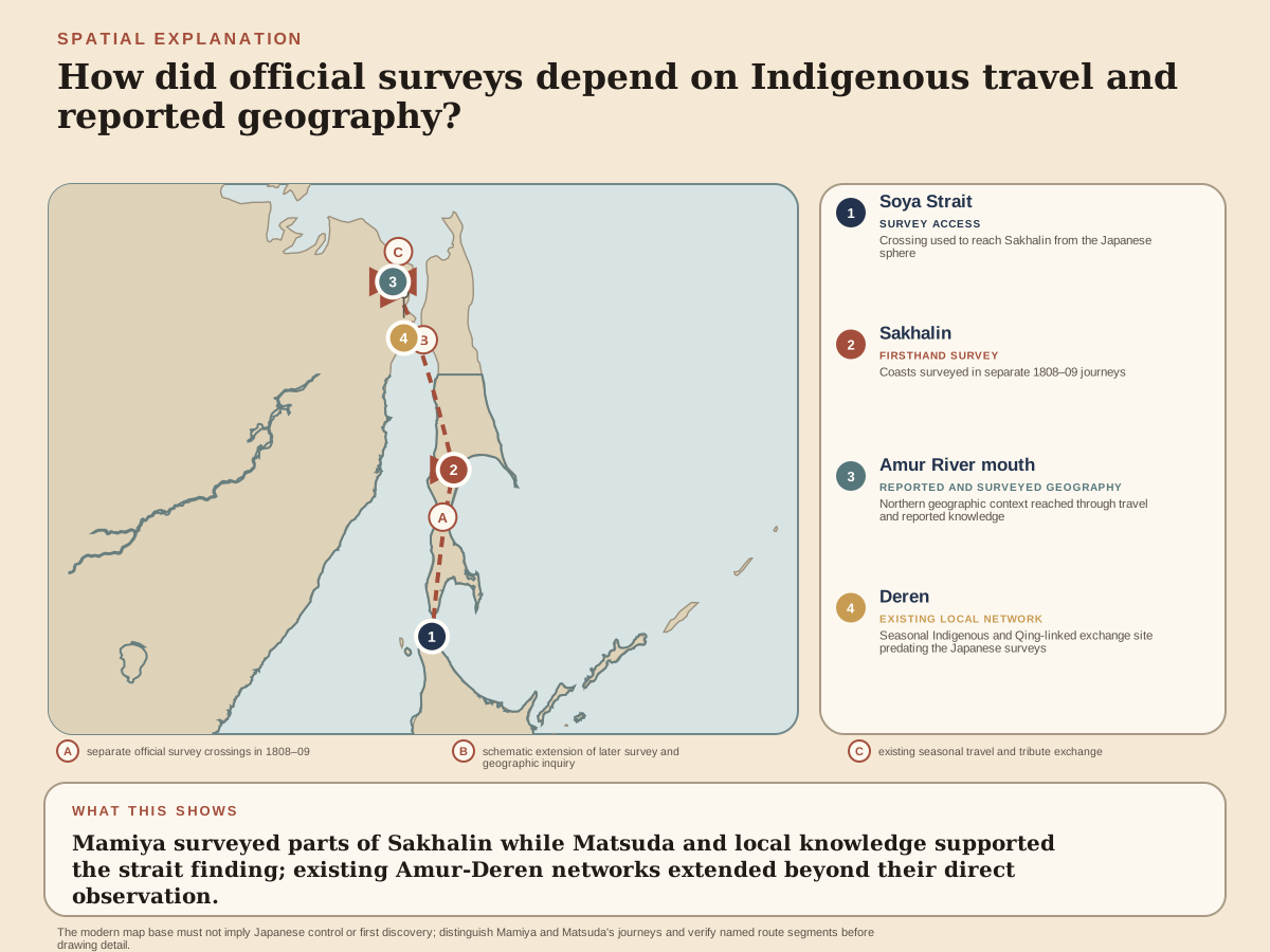
    In 1809 Mamiya returned, crossed from northern Sakhalin toward the continent and traveled up the lower Amur to Deren. He relied on local routes and Indigenous intermediaries. His observations described not an empty frontier but a region shaped by Ainu communities, Nivkh and other peoples, and the trade network Japanese sources called Santan.

    Reports and maps converted that movement into shogunal knowledge. Later European geography attached Mamiya's name to the strait, but the journeys were neither a solitary discovery of an unknown island nor proof of Japanese control over all the places mapped.

    Read Mamiya Rinzō’s Sakhalin and Lower Amur Surveys

    Read the article below. Interactive reading tools are available when scripts load.

    Quick

    Mamiya Rinzō’s Sakhalin and Lower Amur Surveys

    Russian expansion and maritime incidents pushed the Tokugawa shogunate to gather more exact knowledge of Ezo, Sakhalin and the Kurils. Mamiya Rinzō first traveled north with Matsuda Denjūrō in 1808 and confirmed for Japanese officials that Sakhalin was separated from the continent by a strait.

    In 1809 Mamiya returned, crossed from northern Sakhalin toward the continent and traveled up the lower Amur to Deren. He relied on local routes and Indigenous intermediaries. His observations described not an empty frontier but a region shaped by Ainu communities, Nivkh and other peoples, and the trade network Japanese sources called Santan.

    Reports and maps converted that movement into shogunal knowledge. Later European geography attached Mamiya's name to the strait, but the journeys were neither a solitary discovery of an unknown island nor proof of Japanese control over all the places mapped.

    Rinzō came from Kamihirayanagi in Hitachi, a village in present-day Tsukubamirai, Ibaraki. His household combined farming with making hoops for wooden containers. Biographies differ between 1775 and 1780 for his birth; the National Archives account uses the latter, while another signed reference uses the former. The household livelihood supplies firmer context than an exact age at each early turning point. He began outside a hereditary warrior office but developed a skill that government employers needed.

    Mamiya and Matsuda moved along Sakhalin's coasts in 1808. Mamiya's 1809 journey went farther through the northern strait and into the lower Amur trade zone. Boats, interpreters and local guidance were conditions of travel, not background details to a solitary expedition.

    Rinzō’s 1800 employment in Ezo and meeting with the coastal surveyor Inō Tadataka at Hakodate, its southern port, were separate from the previous year’s first journey. Inō’s instruction later included celestial observations for latitude, position north or south of the equator. Land measurements connect distances and directions along a route; observations of the heavens help place that route within a larger geographical frame. Combining them could strengthen a coastal outline beyond a sequence of local distances. The formation joined Murakami’s practical surveying to methods associated with Inō’s national work.

    Classic

    Conditions behind Mamiya Rinzō’s Sakhalin and Lower Amur Surveys

    Sakhalin was an Indigenous homeland and a zone of exchange before Japanese and Russian governments tried to define it as a border. Matsumae trade, fisheries and labor practices had already altered Ainu life, while Russian movement made the shogunate fear that uncertain geography had become a security problem.

    Russian expansion and maritime incidents pushed the Tokugawa shogunate to gather more exact knowledge of Ezo, Sakhalin and the Kurils. Mamiya Rinzō first traveled north with Matsuda Denjūrō in 1808 and confirmed for Japanese officials that Sakhalin was separated from the continent by a strait.

    Rinzō came from Kamihirayanagi in Hitachi, a village in present-day Tsukubamirai, Ibaraki. His household combined farming with making hoops for wooden containers. Biographies differ between 1775 and 1780 for his birth; the National Archives account uses the latter, while another signed reference uses the former. The household livelihood supplies firmer context than an exact age at each early turning point. He began outside a hereditary warrior office but developed a skill that government employers needed.

    Murakami Shimanojō, a geographer working for the shogunate, Japan’s warrior government, taught Rinzō surveying. The techniques included measuring angles and distances to determine positions on land. This was an applied education: a usable observation had to connect one point to another, rather than remain a statement that a place lay somewhere north. Reference accounts also associate recognition of Rinzō’s arithmetic with public works.

    Following Murakami to Ezo in 1799 brought Rinzō into a region where officials needed geographical information. Ezo here means principally present-day Hokkaido and the northern territories associated with its administration. Government work offered travel, instruction and practical assignments beyond his village. It also directed the use of what he learned. His career began through particular teachers and employers, and would continue through a mixture of observation, written reports and official investigation.

    Mamiya Rinzō’s Sakhalin and Lower Amur Surveys in motion

    Mamiya and Matsuda moved along Sakhalin's coasts in 1808. Mamiya's 1809 journey went farther through the northern strait and into the lower Amur trade zone. Boats, interpreters and local guidance were conditions of travel, not background details to a solitary expedition.

    In 1809 Mamiya returned, crossed from northern Sakhalin toward the continent and traveled up the lower Amur to Deren. He relied on local routes and Indigenous intermediaries. His observations described not an empty frontier but a region shaped by Ainu communities, Nivkh and other peoples, and the trade network Japanese sources called Santan.

    Reports and maps converted that movement into shogunal knowledge. Later European geography attached Mamiya's name to the strait, but the journeys were neither a solitary discovery of an unknown island nor proof of Japanese control over all the places mapped.

    Rinzō’s 1800 employment in Ezo and meeting with the coastal surveyor Inō Tadataka at Hakodate, its southern port, were separate from the previous year’s first journey. Inō’s instruction later included celestial observations for latitude, position north or south of the equator. Land measurements connect distances and directions along a route; observations of the heavens help place that route within a larger geographical frame. Combining them could strengthen a coastal outline beyond a sequence of local distances. The formation joined Murakami’s practical surveying to methods associated with Inō’s national work.

    The immediate settlement

    The surveys supplied maps and written reports that distinguished Sakhalin from the continent and described the lower Amur network. They improved the shogunate's geographical knowledge without creating continuous administration or consent across the region.

    Rinzō surveyed western Ezo in 1803 and worked on the Kuril island of Etorofu in 1806. These were journeys through inhabited lands and maritime settings used by Indigenous communities, traders and officials. They expanded his knowledge through successive routes rather than one sudden discovery. The early shogunal survey system was itself cumulative. A later compiler might join observations from several people whose expeditions covered different stretches of coast. Rinzō would become one of the contributors to that larger body of geographical work.

    Russian activity gave northern geography immediate official importance. Attacks on Japanese positions in 1807 exposed weaknesses of defense and administration; Rinzō was questioned in connection with events on Etorofu. Reference accounts say that he was not punished. His ensuing Sakhalin assignment belonged to a government seeking more reliable information about coastlines and approaches. The pressure helps explain why geographical work received support. It also places his measurements within an unequal expansion of official knowledge over lands whose residents already knew and traveled them.

    The event's longer afterlife

    Siebold later publicized the strait in Europe using Mamiya's name. That international afterlife elevated one surveyor while making the knowledge chain less visible. The event matters both for cartography and for the expansion of state attention into northern Indigenous spaces.

    The surveys made northern geography legible to officials confronting Russian expansion, while also recording trading worlds that exceeded any one state's authority.

    Mamiya's achievement depended on Indigenous knowledge and movement. Remembering the strait only as a heroic discovery would hide both the people who enabled the journeys and the later imperial uses of mapping.

    Sakhalin’s relationship to the mainland remained unresolved in earlier Japanese official maps. A 1801 investigation had measured parts of its southern coasts, while information about the north relied on residents’ reports. Some resulting maps retained both island and peninsula possibilities. Rinzō and his fellow shogunal official Matsuda Denjūrō were entering a sequence of investigations with an identifiable gap: a southern outline did not establish how the island ended in the north. The 1808 commission directed two officials toward that missing connection.

    Sources and notes

    1. 間宮林蔵 · Funatsu Isao (船津功)
    2. 北夷分界余話(国の重要文化財) · National Archives of Japan
    3. 間宮林蔵の探検の記録 · National Archives of Japan
    4. 18,19世紀におけるアムール川下流域の住民の交易活動 · Sasaki Shirō (佐々木史郎)
    5. 清朝のアムール支配の統治理念とその実像 · Sasaki Shirō (佐々木史郎)
    6. ウイマㇺレプンカ サンタン交易と蝦夷錦 · National Ainu Museum
    7. 間宮林蔵がシーボルトを密告したという説があるが、そのことがわかる資料はあるか。 · Saitama Prefectural Kuki Library, via National Diet Library
    8. シーボルトの生涯とその業績関係年表1(1796–1832年) · Ishiyama Yoshikazu (石山禎一) and Miyazaki Katsunori (宮崎克則)
    9. 高橋景保 · National Diet Library
    10. 北海道地図の変遷―江戸初期から明治初年まで― · Takagi Takayoshi (高木崇世芝)
    11. 間宮林蔵と樺太 · Hokkaido Government Red Brick Office Exhibition Guide

    About these sources

    Reading preferences

    Text size
    Glossary intensity

    Choose how much explanation appears as you read.

    Saved on this device. All terms remain available in the glossary.

    Browse the glossary →
    History Omakase

    Opening reading…