Isawa Castle's 670-metre enclosure
胆沢城跡
Attraction
Isawa Castle was a square government and military compound about 670 metres on each side, enclosed by a rammed-earth wall. Sakanoue no Tamuramaro directed its construction in 802, and by 808 the Chinjufu, the headquarters supervising northern military affairs, had moved here from Taga Castle. Inside stood a government hall for ceremony, offices, kitchens, and supply facilities rather than a medieval keep. Most of that architecture is gone. The size is now understood through excavated boundaries, plans, and the modern historical park at the southern entrance, which restores spatial legibility without pretending to be the original complex.
Current visibility
The enclosure and building system survive through archaeology, marked space, and modern park interpretation; no ninth-century castle tower existed here.
The southern approach and modern historical park
Attraction
The outer South Gate zone has been prepared as Isawa Castle Historical Park, using a straight, pale surface line and landscaped ground to reveal the approach into the enclosure. This is interpretation built over and around protected archaeology, not a surviving paved avenue. Its value is orientation: it shows how entry, wall, gate, and inner axis controlled movement across a site now divided by fields, roads, and settlement. The absence of a full gate reconstruction keeps attention on scale and alignment. Finds and fuller explanation are held at the nearby archaeological center rather than exposed indefinitely in the field.
Current visibility
The approach and park presentation are modern; original gate and wall fabric is archaeological and largely below ground.
Documents, tiles, and the labor of frontier government
Attraction
Excavations at Isawa recovered wooden tablets, inscribed pottery, calendar fragments, and lacquer-paper documents connected with soldiers and administration. Roof tiles came from regional kilns, while food facilities and offices reveal the routines needed to sustain a distant headquarters. These objects shift the site's emphasis away from one commander. The state advanced through record-keeping, assigned labor, migration, supply, ritual, and repeated maintenance as well as battle. Because fragile finds are conserved indoors, the field alone cannot tell this story. The adjacent Ōshū City Archaeological Research Center is the appropriate Extension for seeing the material archive under managed conditions.
Current visibility
The archaeological site is outdoors, but original documents and artifacts are conserved and displayed indoors under facility schedules.
Aterui's surrender and the cost of incorporation
Attraction
Ōshū City's history records both the surrender of the Emishi leaders Aterui and More and the construction of Isawa Castle in 802. The fortress therefore marks a political transformation imposed after decades of warfare, not the peaceful arrival of neutral administration. In 804 the new Isawa district formalized the area's incorporation into the statutory system. The site should hold both perspectives: Tamuramaro's career and the court's institutional reach are central, but so are local resistance, defeat, displacement, and the reorganization of land and population. No single monument on the field represents Aterui; the relationship is historical and must be explained rather than invented as a surviving personal location.
Current visibility
The political transformation is read through the castle landscape and historical record; no authenticated Aterui structure survives at the site.
Takkoku's cliff hall and a qualified founding tradition
達谷窟毘沙門堂
Attraction
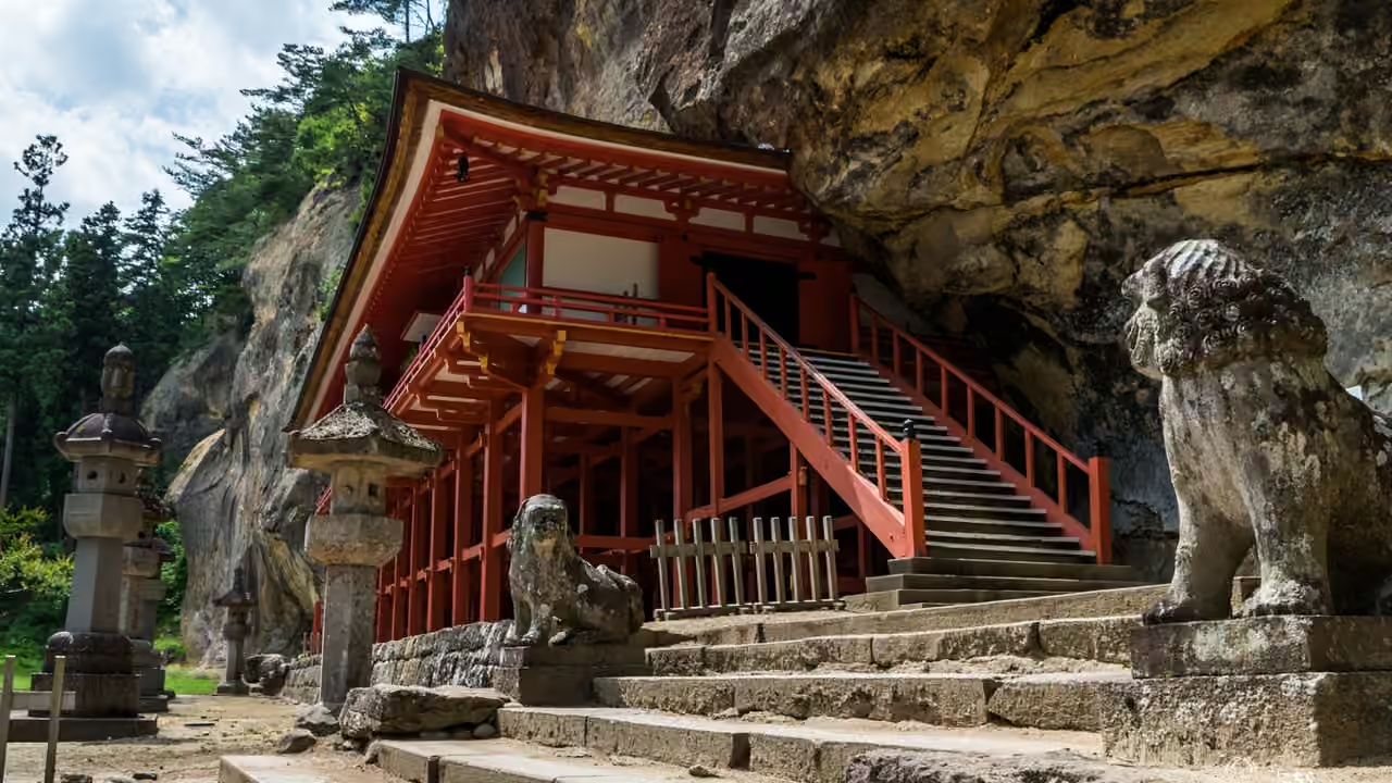
Takkoku's Bishamondō stands against a long rock face in a raised, stage-like form. Temple tradition says Tamuramaro founded a sanctuary here in 801 after victory and installed Bishamonten as a protector; later sources transmitted that account. It should be identified as tradition, not treated as contemporary proof of every detail. The present cliff hall is also not a ninth-century survivor: an early modern building burned in 1946 and the hall was reconstructed in 1961. What is securely visible is the enduring sacred use of the cliff, the rebuilt architectural relationship between rock and platform, and a tradition that converted military conquest into religious memory.
Current visibility
The cliff setting is original landscape, but the present Bishamondō dates to the 1961 reconstruction; the principal icon is not ordinarily displayed.
The rock-cut Buddha, pond, and medieval temple landscape
岩面大佛・蝦蟆ヶ池
Attraction
West of the hall, a large weathered Buddha face is cut high into the cliff; below, the Gama-ga-ike pond and its island Benten hall shape the foreground. The national cultural-property record does not fix the image's identity with certainty, identifying it as Dainichi or Amida. That caution is more useful than a confident label. Archaeology has found stonework before the cliff, while records indicate that numerous subsidiary temples once spread around the sanctuary in the medieval period. The present compound is therefore only a surviving center of a larger religious landscape whose buildings contracted, burned, and changed over time.
Current visibility
The weathered rock-cut face, cliff, pond, and current buildings are visible; much of the medieval subsidiary-temple landscape has disappeared.
Takkoku on the northern road to Hiraizumi
Attraction
Takkoku occupied a constricted valley beside a route understood as part of the Ōshū highway linking Hiraizumi with surrounding regions. Minamoto no Yoritomo's recorded visit in 1189, after the Ōshū campaign, confirms that the sanctuary had become a recognized landmark centuries after the age attributed to Tamuramaro. Its roadside position explains why the place accumulated political as well as devotional meaning. The current road and terrain still make that threshold quality legible, although they do not preserve an untouched medieval surface. This later history connects Takkoku to Hiraizumi without making the site a component of Isawa Castle's ninth-century enclosure.
Current visibility
The valley and roadside relationship remain visible; the modern road is not presented as an intact ancient or medieval highway surface.